With four days of freedom ahead for much of the UK, carve out some time to enjoy one of these fine Easter walks with family or friends.
The long bank holiday is a great excuse to get out for a day – especially if your four-day weekend is already full of life admin and pencilled-in pub sessions. From relatively small Munros to lochside views by way of mini scrambles and seascapes, enjoy one of these Easter walks as mapped by The Great Outdoors’ expert contributors.
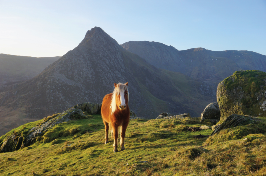
Main image: one of the Carneddau ponies in front of Tryfan. Credit: Francesca Donovan.
A selection of Easter walks in the UK
- Ben Vorlich – Arrochar Alps (the most ascent of our Easter walks)
- Loch Trool, Galloway Forest Park – Southern Uplands (the shortest of our Easter walks in duration)
- Cross Fell – North Pennines (the longest of our Easter walks in mileage)
- Lingmoor Fell, Blea Tarn and Cathedral Caves – Lake District
- Alport Castles – Peak District
- The Carneddau – Eryri/Snowdonia
- Yr Eifl – North Wales (the shortest of our Easter walks in mileage)
- Mynydd Troed and Mynydd Llangorse – Brecon Beacons
- King’s Tor – Dartmoor (the least ascent of our Easter walks)
1. Ben Vorlich
While The Cobbler commonly attracts the plaudits (and crowds), James Forrest prefers Ben Vorlich for his Arrochar Alps adventure.
START/FINISH: Inveruglas car park (G83 7DP) off the A82, to the north-east of the power station (NN322098) | MAPS: OS Explorer OL39 (1:25k), OS Landranger 56 (1:50k), Harvey British Mountain Map Southern Highlands (1:40k) | DISTANCE: 13.1km / 8.1 miles | ASCENT: 962m / 3,156ft | DURATION: 5 hours
Views from the ascent of Ben Vorlich.
Credit: James Forrest
Complex, steep and dramatic, the Arrochar Alps are a compact group of peaks in the Loch Lomond and The Trossachs National Park. There are four Munros here – Ben Vorlich, Ben Vane, Beinn Narnain and Beinn Ime – but it is a Corbett that steals the limelight. The Cobbler is a weirdly-shaped, craggy-topped mountain that entices throngs of visitors, particularly weekend hikers from Glasgow and its surrounding suburbs. To dodge the crowds without compromising on the hillwalking experience, perhaps a better option is the simple but superlative ascent of Ben Vorlich to the east of Loch Sloy.
At 943m, Ben Vorlich (Mountain of the Bay) is small by Munro standards, but its steep-sided flanks still make for a lung-busting, calf-burning climb. Handfuls of Haribo will get you through the seemingly never-ending slog up Lag Dubh from the Loch Sloy access track, and once you top out onto the south-eastern ridge your efforts will be amply rewarded. The views across isle-dotted Loch Lomond – which stretches out sumptuously into the distance – will remedy even the achiest of muscles, and before you know it you’ll be eying up neighbouring Ben Vane (916m) across the valley. Maybe I’ve got the energy for another Arrochar Alps adventure tomorrow, after all?
See the full route description for Ben Vorlich as mapped by The Great Outdoors’ contributor, James Forrest, here.
2. Loch Trool
For an easy walk in tough Galloway country, Ronald Turnbull suggests the path around its loveliest loch, Loch Trool.
START/FINISH: Walkers’ car park at Caldons (can be busy at holiday times) NX396790 | MAPS: OS Explorer 319 (1:25k), OS Landranger 77 (1:50k), Harvey Superwalker Galloway Hills (1:25k) | DISTANCE: 10km / 6.5 miles [longer version 16.5km/10.5 miles] | ASCENT: 100m / 300ft [longer version 300m / 1000ft] | DURATION: 2 – 2.5 hours [longer version 4 – 4.5 hours]
Picnic promontory, Loch Trool.
Credit: Ronald Turnbull
With granite slabs, grassy tussocks and deep black peat, the Galloway Hills are lovable but tough. There is one really easy walk, however; and it’s a good ‘un. A smooth and well-made path runs around beautiful Loch Trool, through ancient oakwood as well as young, regenerating birch trees which open wide views across the water to the Merrick range. Everyone enjoys this walk – well, almost everyone. A bloke called Aymer de Valence had a bad time on it, back in 1307. Chasing Robert the Bruce and his band of guerilla fighters into the hills, he got ambushed on this very path, granite boulders rolled down between the trees, and wild men with swords coming right down behind them.
For your own closer encounter with rugged Galloway, there’s an option at waypoint three to head up into the hills, still on a comfortable gravel track, to the Axe Head Stane overlooking Loch Dee below the crags of Curleywee.
See the full route description for Loch Trool as mapped by The Great Outdoors’ contributor, Ronald Turnbull, here.
3. Cross Fell
James Forrest climbs England’s highest peak outside the Lakes, the leviathan of the North Pennines, Cross Fell.
Start/Finish: Small car park next to Kirkland Hall (GR: NY650325) | Maps: OS Explorer OL31 (1:25k), OS Landranger 91 (1:50k) | Distance: 12.6 miles | Ascent: 2,875ft/ | Duration: 7 hours
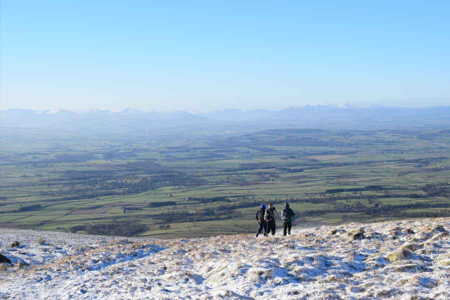
Three hikers descending Cross Fell.
Credit: James Forrest
The leviathan of the North Pennines, Cross Fell (893m/2930ft) is England’s highest mountain outside of the Lake District. It’s a mountain of soft, smooth lines, devoid of the rocky drama of its Lakeland neighbours, but it still has charm, especially if you spend the night at Greg’s Hut, a former miners’ house turned rustic mountain bothy. Named after John ‘Greg’ Gregory, who died in a climbing accident in the Alps, Greg’s Hut is the highest bothy in England.
Cross Fell is also home to the UK’s only named wind – the fierce Helm Wind, a strong north-easterly that batters the mountain’s south-western slopes for much of the year. The route traverses the scree belt at Crossfell Well, a small spring, to emerge at the summit’s fittingly cross-shaped wind shelter, before veering south-east to Tees Head. Next comes an out-and-back on the Pennine Way’s mill flagstones to Little Dun Fell and Great Dun Fell – the latter adorned with a huge, golf ball-shaped radar dome – before looping downhill via Wildboar Scar.
See the full route description for Cross Fell as mapped by The Great Outdoors’ contributor, James Forrest, here.
4. Lingmoor Fell, Blea Tarn and Cathedral Caves
Facing an uncertain forecast, Francesca Donovan heads for a low-level exploration of Lingmoor Fell and the iconic scenes in its small shadow.
Start/finish: Blea Tarn National Trust car park (GR: NY295043) | Distance: 9km/5.6 miles | Ascent: 381m/1,250ft | Duration: 3 to 4 hours | Maps: OS Maps Explorer (1:25k) OL6 English Lakes South-Western Area & OL7 English Lakes South-Eastern Area
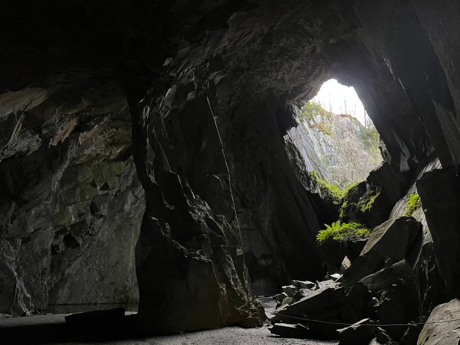
Inside Cathedral Cave.
Credit: Francesca Donovan
On a blustery and wet day in the central fells, when your heart is set on scrambles, a cautious but pleasing diversion might send you to Lingmoor Fell (1,530ft/466m) for a low-level, low-stakes Easter walks adventure. The compact circular makes up in iconic Lakeland scenery what it lacks in elevation. Thanks to Lingmoor’s topographical isolation, your moderate effort will be rewarded with views of the Langdale Pikes. At times, they loom large in the landscape. When they are out of sight, the rolling fields punctuated by pretty tarns and views as far as Windermere will ensure you are not preoccupied with distractions.
The green slate quarrying history here adds a little magic to the route, too. You can stride along the Great Wall of Lingmoor – as the ridge wall is affectionately named – and marvel at Cathedral Caves, the majestic main chamber of the old interlinked quarries looking down over Little Langdale. If you get thirsty on route, the Three Shires Inn is just off course. But continue on, and beyond the small waterfalls along Bleamoss Beck, you can come to rest at the Blea Tarn viewing point. Here, Side Pike and Rakerigg offer a picture-perfect natural frame for the Langdale Pikes. Alternatively, The Old Dungeon Ghyll isn’t far away for a post-walk pint – and Hardknott Pass is something to behold (in low gear). With all this on offer, it’s an undeniably popular area for walkers and photographers alike. You may not find solitude but you will have a spectacularly varied ramble.
See the full route description for Lingmoor Fell as mapped by The Great Outdoors’ contributor, Francesca Donovan, here.
5. Alport Castles
Starting your scrambling journey? Take a jaunt up The Tower at Alport Castles for some low-stakes family-friendly fun, says Francesca Donovan.
Start/finish: Haggwater Bridge car park (GR: SK 162 886) | Maps: OS Explorer OL1, The Peak District – Dark Peak area (1:25k) | Distance: 10 miles/17km | Duration: 6 hours | Ascent: 522m/1,713ft
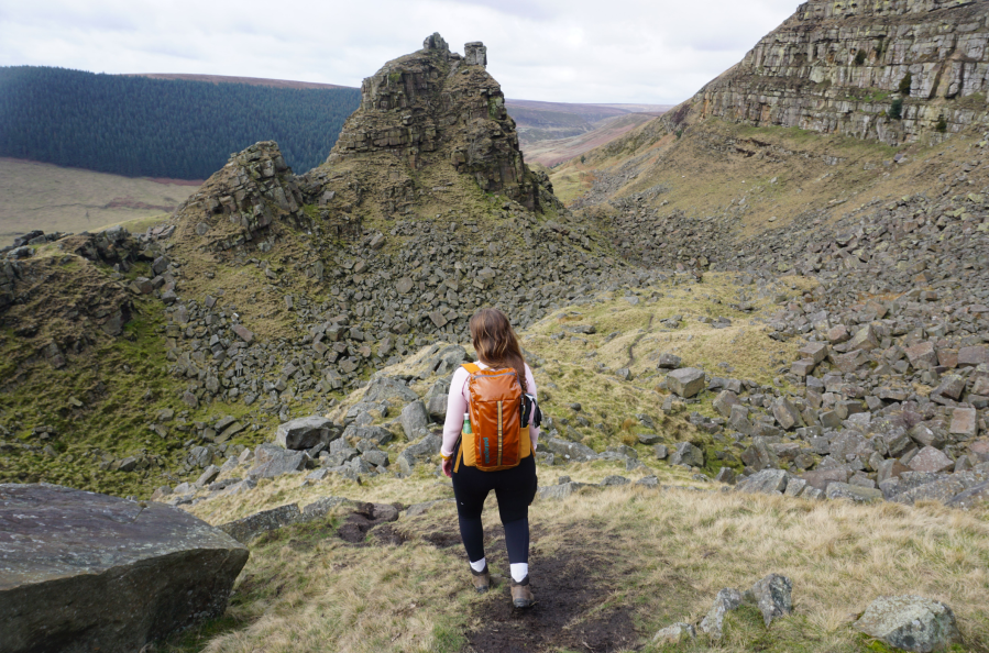
Walking towards The Tower past Little Moor.
Credit: Francesca Donovan
The Peak District isn’t well-known for scrambling. The gritstone edges are favoured instead by boulderers and climbers and scrambling the cloughs up to Kinder can be tricky in wet weather. But there’s another spot where you can cut your teeth; Alport Castles. Here sits The Tower, the geologically impressive consequence of a huge landslide, the causes of which are still debated. This area is well-trodden by walkers who skirt the gritstone boulders lying dormant below Alport Moor, admiring The Tower from afar. Here, you can spend some time with hands on rock.
The scrambling is very easy grade 1 (a grade 0.5, if you like) if you stick to the obvious east route up The Tower. Or pick your own Easter walks route, tackling it straight on for a vertical ascent from Little Moor. Keep an eye out for the resident peregrine falcons who nest in the layers of rock over on the other side of the landslide site. It’s a short scramble but there’s plenty of chance to scamper through the boulder fields before heading back above the farmland with views over to The Great Ridge.
See the full route description for Alport Castles as mapped by The Great Outdoors’ contributor, Francesca Donovan, here.
6. The Carneddau
Francesca Donovan takes a walk on the quiet plateaus of Eryri to the Carneddau via the famous stiles of Pen yr Ole Wen.
Start/Finish: A5 layby parking (GR: SH 668605) | Maps: OS Explorer OL17 Snowdon/Yr Wyddfa (1:25k) | Ascent: 2,925ft/1008m | Distance: 9.1 miles/14.7km | Duration: 6 hours
Pen yr Ole Wen’s photogenic stile.
Credit: Francesca Donovan
Here’s my unpopular opinion: I think Tryfan is best experienced from the “other” side of the Nant Ffrancon. If you’re looking for one of the UK’s best big mountain Easter walks with space to roam, reach out and touch the sky, the Carneddau mountain range offers a charming, if less rugged, alternative just a stone’s throw away from the Glyderau’s imposing crags. And yet, ascending via Pen yr Ole Wen from the east (avoiding the relentless scree of its south face) still offers a decent little scramble up to those high, wide plateaus.
Here, on a calm, bluebird day you’ll be treated to views north out to sea as well as the summit of Yr Wyddfa to the south, beyond layer upon layer of mountain magnificence. Towering above Ffynnon Lloer, the Cambrian Way paves an expanse that allows you to stay high for longer. Passing the Ffynnon Llugwy reservoir on your return, you might even catch a glimpse of your altitude-induced grin in a mirror reflection as you descend back down into the crowds along the A5 and towards Ogwen Cottage.
See the full route description for the Carneddau as mapped by The Great Outdoors’ contributor, Francesca Donovan, here.
7. Yr Eifl
Roger Butler enjoys memorable views on the sunny Lleyn Peninsula walking Tre’r Ceiri, Garn Ganol and Garn Fôr – the three tops of Yr Eifl.
Start/Finish: Llithfaen, grid ref SH357431 | Map: OS Explorer 253 and 254 (1:25k), OS Landranger 123 (1:50k) | Distance: 9.25km/5¾ miles | Ascent: 570m/1875ft | Duration: 5 hours
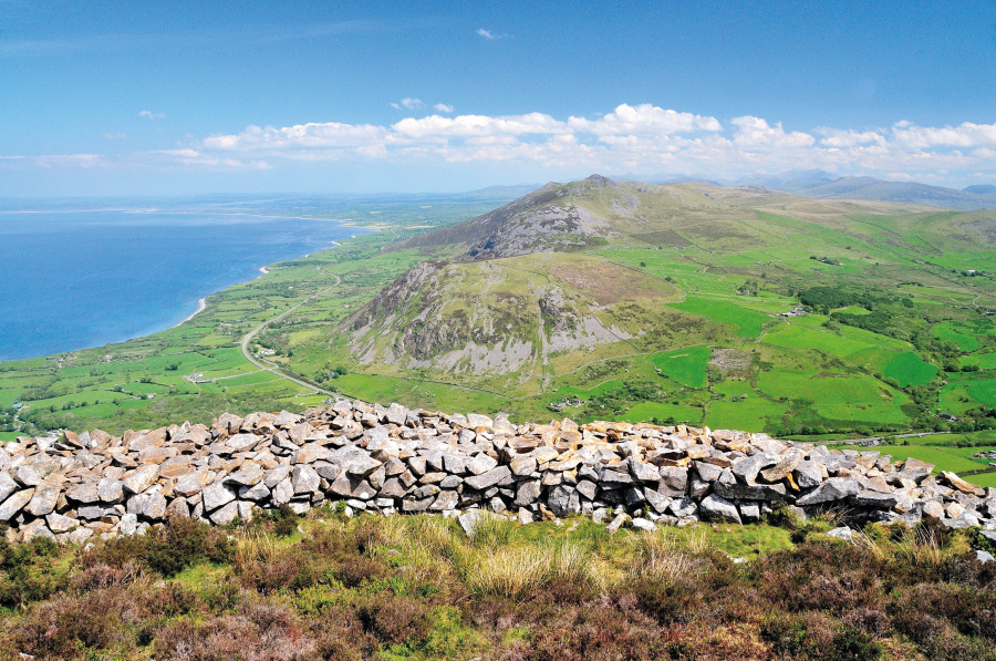
View looking north – east fro m Tre’r Ceiri to Moel – Pen – llechog and, beyond, Gyrn Ddu and Gyrn Goch.
Credit: Roger Butler
We all know what it’s like to be stuck in Snowdonia when it’s raining: the windscreen wipers whip back and forth as you peer into those blankets of grey cloud. But, just half an hour away, the sun could well be shining on the lesser-known Lleyn Peninsula, where the sea-girt panorama from a trio of prominent hills, often known as The Rivals, will always rival any view in the National Park. These three tops, rising steeply above the north coast, are collectively named Yr Eifl.
Tre’r Ceiri (‘the town of the giants’) is capped by a spectacular Iron Age fort with huge stone walls and clusters of hut circles. Garn Ganol (‘centre cairn’) is the highest summit whilst Garn Fôr (‘sea cairn’) is perched above vertical cliffs. Joyful choughs wheel over the crags and on a fine day the views stretch all the way from the Isle of Man to the Wicklow Mountains.
See the full route description for Yr Eifl as mapped by The Great Outdoors’ contributor, Roger Butler, here.
8. Mynydd Troed
Steve Eddy takes in sweeping views and mixed terrain on a walk up Mynydd Troed – or ‘Foot Mountain’ – in the Brecons.
Start/finish: B4560 at Cathedine (GR: SO144250) | Distance: 7.6 miles/12.2km | Ascent: 1,825ft/556m | Duration: 5 to 6 hours | Maps: OS Explorer OL13 – Brecon Beacons National Park Eastern Area (1:25k)
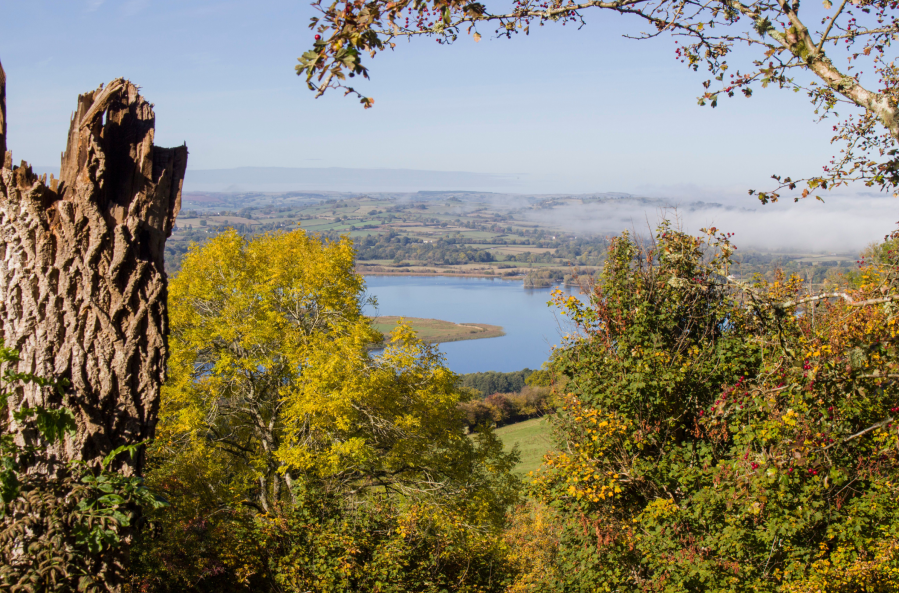
Mynydd Troed and Langorse lake.
Credit: Steve Eddy
This varied walk combines tree-lined paths between moorland and rough grazing, frequent lake views, a steep climb up Mynydd Troed (‘Foot Mountain’, 609m), and relatively level walking on top of Mynydd Llangorse. Much of the time you’ll enjoy sweeping views of beautiful Llangorse Lake, often glimpsed through hazel and ash bordering field edges, and the distinctive peak of Pen y Fan on the western horizon. You’ll certainly see gorse, as the name Llangorse suggests, as well as plenty of bracken on the lower slopes and heather on top, and very likely a few red kites. The broad, grassy paths on top of Mynydd Llangorse are also favoured by horse riders.
In addition, there’s a tiny shepherd’s cottage to look out for, perfectly restored in memory of Kevin Thomas, an outdoor pursuits leader who drowned whilst going to rescue a child. The seat outside is a perfect place to have lunch, or just sit and enjoy the view of the lake. A surprising feature nearby is a large walnut tree. Perhaps the shepherd liked walnuts!
See the full route description for Mynydd Troed as mapped by The Great Outdoors’ contributor, Steve Eddy, here.
9. King’s Tor
Roger Butler takes an old railway line to King’s Tor to walk the sculptural and weather-beaten outskirts of Dartmoor.
Start/Finish: Car park by small pool on south side of B3212 (GR: SX557706) | Distance: 8 miles/12.9km | Ascent: 1,000ft/305m | Duration: 4 to 5 hours | Maps: OS Explorer OL28 – Dartmoor (1:25k), OS Landranger 191 – Okehampton & North Dartmoor (1:50k)
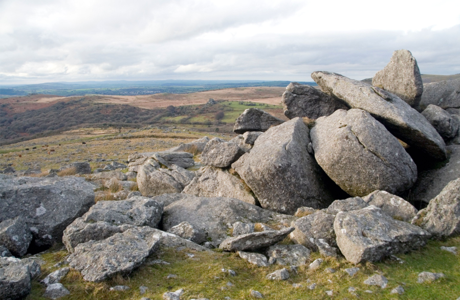
Looking west from the boulders at the top of King’s Tor.
Credit: Roger Butler
The wild heart of Dartmoor is infamously boggy, but you don’t always need to hike into the squidgy interior to enjoy this granite-hewn landscape, where bronze-coloured heath sweeps in every direction and hilltops always seem to be capped with a sculptural weatherbeaten tor.
The line of the former Princetown Railway, high to the east of Tavistock, provides straight-forward access to a number of granite outcrops but also serves up some fascinating history: a scattering of ancient hut settlements, wriggling leats that once took fresh water down to Plymouth, and quarries where stonemasons grafted to create Nelson’s Column. There are fine views too: the eerie shapes and shadows around distant Great Mis Tor and the deep wooded valleys down by the River Tamar. From up here, Cornwall looks like a faraway kingdom.
The walk also cuts across open moorland to North Hessary Tor and returns via tussocky Walkhampton Common and a couple of rocky tops. You’ll even peep over the gaunt rooftops of Dartmoor Prison!
See the full route description for King’s Tor as mapped by The Great Outdoors’ contributor, Roger Butler, here.