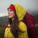
The humble bothy provides shelter and camaraderie in the most remote landscapes in the UK. Some hillwalkers seek them to enjoy warmth, others to be a part of their shared history. Either way, bothy nights are sure to provide some of your finest mountain evenings spent in front of the fire. Here is a selection of the best bothy walks in Britain as well as detailed routes explaining how to reach your overnight destination.
But first, what is a bothy?
The UK’s answer to Europe’s alpine huts, bothies are basic shelters dotted around our more remote mountainous areas. Indeed, it is thought the word bothy derives from the Irish bothán and Scottish Gaelic bothan or bothag – all meaning ‘hut’. Often built from stone within the last century – Corrour bothy, the oldest in the UK, celebrated a century of public use in 2020 – to provide protection from wind, rain and snow, they are (mostly) left unlocked for those who need them for shelter free of charge.
However, comfort levels vary from bothy to bothy. Some have raised wooden or stone benches on which to lay your sleeping mat with wood burning fires – but no water, electricity or gas supply. Others are more sparsely decorated.
Corrour bothy, the oldest in the UK, celebrated a century of public use in 2020.
The land upon which each bothy sits may be owned by one of the UK’s landowners. Thus, most are owned by an estate. However, it’s rare for the estate to have a close involvement with upkeep beyond permitting the bothy’s existance. As bothies are generally considered to belong to no single person, instead serving many kinds of outdoors folk, they are protected and conserved on a voluntary basis by the Mountain Bothies Association (MBA). Each bothy has different rule with which you must comply based on its surrounding environmental factors.
Before heading out, please ensure you fully understand and so can comply with the Bothy Code.
The best bothy walks
- Kearvaig bothy on the Cape Wrath Trail
- Bob Scott’s and the Hutchison Memorial Hut, Ben Macdui
- Meall a’ Bhuachaille via Ryvoan Bothy
- Clennoch Bothy via Moorbrock Hill
- Ettrick Horseshoe via Over Phawhope
- Merrick via Culsharg bothy
- Skiddaw via Lingy Hut
- Arenig Fawr
- Greg’s Hut on Cross Fell
Cape Wrath Trail (Blairmore to Cape Wrath section)
The Cape Wrath Trail is one of Scotland’s best-loved long-distance routes, and the final section to the lighthouse offers the Cape Wrath experience in miniature, argues Alex Roddie.
START/FINISH: Car park at Blairmore near Kinlochbervie, NC195600, to Kyle of Durness ferry crossing, NC371660 | MAPS: OS 1:25,000 Explorer sheet 446 (Durness & Cape Wrath), OS 1:50,000 Landranger sheet 9 (Cape Wrath), Harvey 1:40,000 XT40 Cape Wrath Trail North | DISTANCE: 41.3km / 25.7 miles | ASCENT: 615m / 2,018ft | DURATION: 2 to 3 days

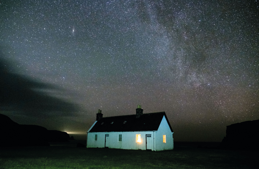
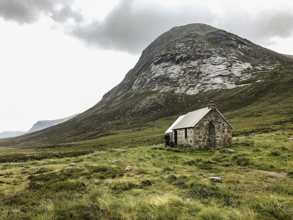
The Milky Way over Kearvaig. Credit: Alex Roddie
Many long-distance walkers dream of hiking the Cape Wrath Trail one day. It’s got everything: wildness, mountain views, remote country, and bothies a-plenty. But what if you don’t have two weeks to hike it in one go? Many of the CWT’s sections are of exceptionally high quality, and if you ask me which is best, I might give a different answer each time – they’re all that good.
However, if you are looking for a section that is representative of the CWT experience, with a good mixture of grand scenery, legendary bothies, and good old-fashioned off-path navigation, you could do a lot worse than the northernmost stretch. Starting at Blairmore just north of Kinlochbervie, the trail visits Sandwood bay and Strathchailleach bothy before plunging into the wild landscape of Cape Wrath. Round it off with a stay at Kearvaig bothy before returning via ferry to Durness.
Alex Roddie has mapped the full route to Kearvaig Bothy for The Great Outdoors. You can also read more about walking the full Cape Wrath Trail as guided by Andy Wasley.
Bob Scott’s and the Hutchison Memorial Hut, Ben Macdui
Watch your step in the Cairngorms, says Craig Weldon – you might be being followed!
START/FINISH: National Trust for Scotland Linn of Dee carpark; NO063898 | MAPS: OS Explorer OL57 & OL58 (1:25k), OS Landranger 36 & 43 (1:50k), Harvey British Mountain Map Cairngorms & Lochnagar (1:40k) | DISTANCE: 32km/20 miles | ASCENT: 1000m/3,300ft | DURATION: 9.5 hrs
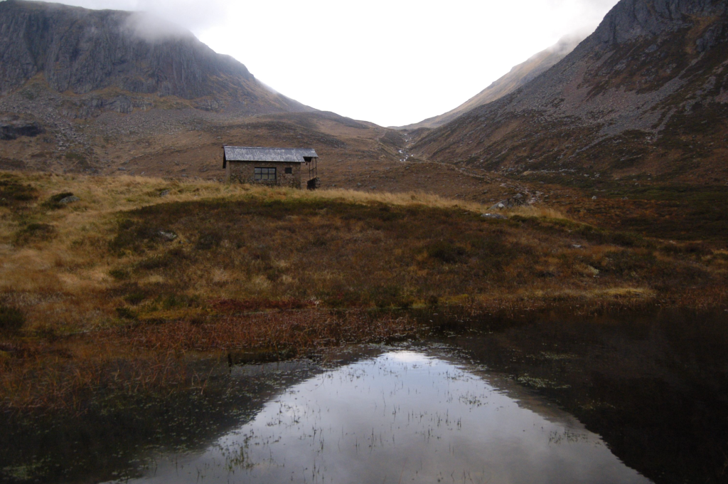
Hutchison Memorial Hut. Credit: Craig Weldon
The Cairngorms have always been Scotland’s historic wilderness: too high, barren and windswept to sustain human life, they are stalked instead by the terrifying creatures of folklore. Creatures such as Lamh Dearg (bloody hand), who haunts the paths challenging victims to a fight. Accept! Those who refuse he kills, but those who face up to his challenge he allows to pass as a friend. It’s no wonder the summit too has its spectre, Am Fear Liath Mor, the Big Grey Man of Ben Macdui.
Rarely seen but sometimes sensed, the Grey Man is responsible for those eldritch neck prickles when you are alone in the mist and become convinced someone is just behind you. Whether the spirit of the mountain is a Brocken spectre, or infrasound, or something else entirely, it exists: many experienced hillwalkers can testify to an odd or uncanny experience when up these hills and far from home. Take care of yourself on the Cairngorm plateau – there’s more to deal with out there than bad weather.
Craig Weldon has mapped the full route to Ben Macdui for The Great Outdoors.
Meall a’ Bhuachaille via Ryvoan Bothy
One of the most accessible mountains in the Northern Cairngorms, Meall a’ Bhuachaille, makes a fine short autumn hillwalk, says Alex Roddie.
START/FINISH: Car park at Glenmore Visitor Centre (GR: NH978097)| MAPS: OS 1:25,000 Explorer sheet OL57 (Cairn Gorm & Aviemore), OS 1:50,000 Landranger sheet 36 (Grantown & Aviemore), Harvey 1:40,000 British Mountain Map (Cairngorms & Lochnagar) | DISTANCE: 8.9km / 5.5 miles | ASCENT: 505m / 1,657ft | DURATION: 3 to 4 hours
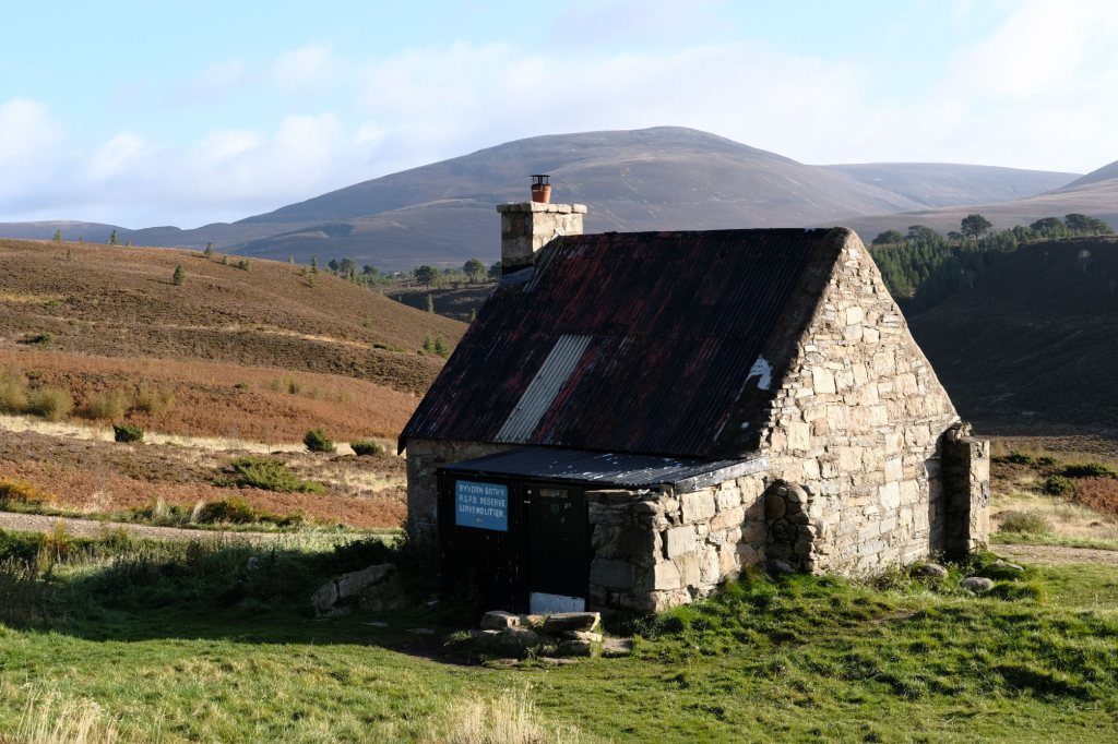
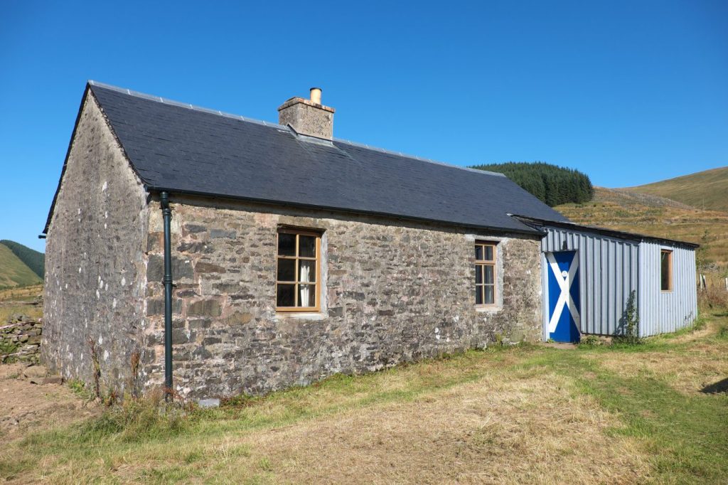
Ryvoan Bothy. Credit: Alex Roddie
The Cairngorms form a vast landscape of rolling plateaus, remote corries, rugged crags, and deep glens. It’s also a subtle place, and many find that only after repeated visits do they start to get a real feel for it. While many of these mountains are big days out and require a good degree of fitness and experience, Meall a’ Bhuachaille, a Corbett rising north of Glenmore, is an exception. Although there is some steep walking on the way up, this is a relatively short hike by Cairngorms standards and far more accessible than, say, Braeriach.
With parking and accommodation options at Glenmore, this hill is feasible in half a day – and the walk is truly varied, with beautiful forest views, a stunning lochan, and even a bothy. Meall a’ Bhuachaille’s position as an outlier from the main Cairngorms gives it an uninterrupted panorama of the Northern Corries from the top. It’s a popular hill for ski touring in the winter, although it’s perhaps at its best in autumn, when the forest colours come to life.
Alex Roddie has mapped the full route to the Ryvoan Bothy for The Great Outdoors.
Clennoch Bothy via Moorbrock Hill
Ian Battersby finds a relaxed approach to Clennoch Bothy and Moorbrock Hill wins the day.
START/FINISH: Verge parking near Craigengillan Bridge; NX638948 | MAPS: OS Explorer OL328 (1:25k), OS Landranger 77 (1:50k) | DISTANCE: 19.3km / 12 miles | ASCENT: 676m / 2,218ft | DURATION: 6 hours plus bothy time
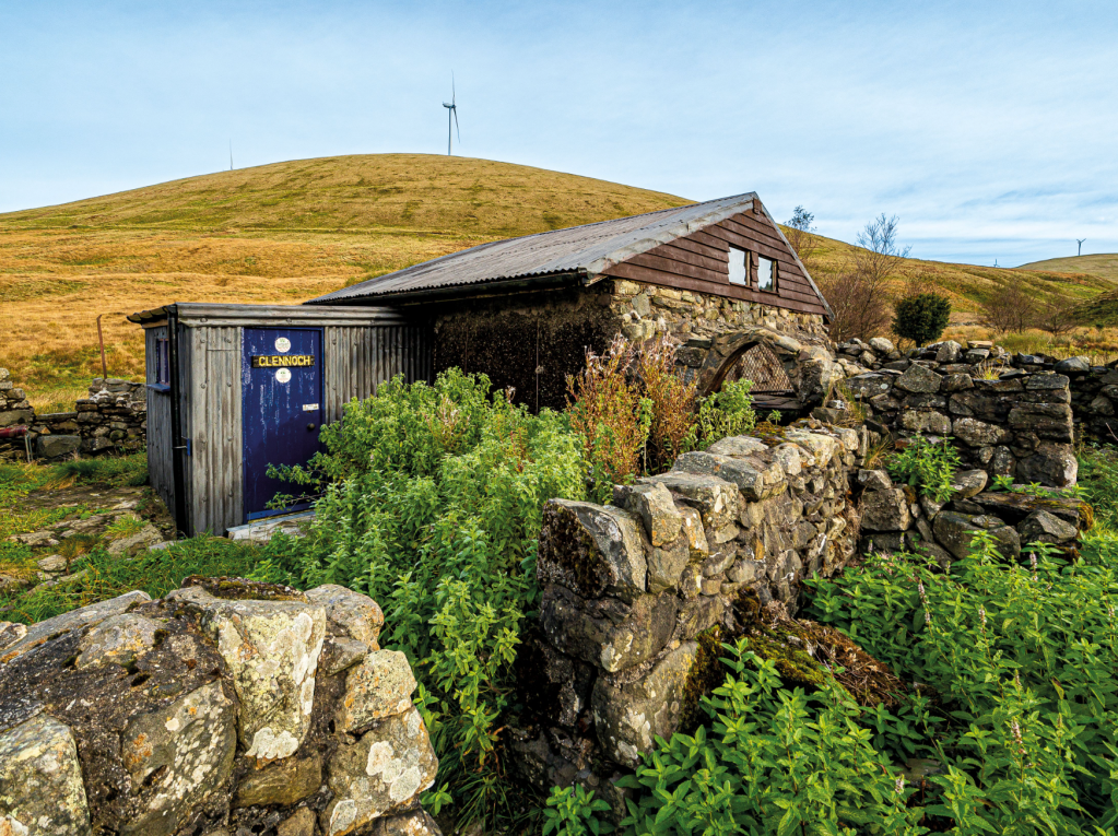
Clennoch Bothy. Credit: Ian Battersby
Most careful plans work well, but changes on the ground can sometimes thwart no matter how cunning and creative we may become. Climbing Cairnsmore of Carsphairn from Craigengillan demonstrates the point. There are good tracks through the Moorbrock estate and associated pine plantations, but miles of new deer fencing now block access from them to the mountains. Walking some of the fence line and scanning with binoculars fail to find a way, but finally Clennoch Bothy can lift the spirits of the disheartened.
First break through a flutter of birds attracted by well-placed feeders and open a cheery light blue door. Through the porch a bright, well maintained dwelling with sleeping platforms for four awaits. There are chairs and a worktop for making a brew or more. Information posted on walls tells a history of this old shepherd’s abode. Lacking a fire place it may best be used as a cosy shelter in colder months in which to concoct plan B, and returning via Moorbrock Hill provides an answer. Outside a nearby pond and coiling stream make nice focal points, and with improving luck roe deer or a fox may pass nearby.
Ian Battersby has mapped the full route ton Clennoch Bothy for The Great Outdoors.
Ettrick Horseshoe via Over Phawhope
Vivienne Crow strides out along roller-coaster ridges in the Southern Uplands on the Ettrick horseshoe.
START/FINISH: Parking area at Potburn road end, 10.6km (6.5 miles) south-west of Ettrick, GR NT189092 | MAPS: OS Explorer 330 (1:25k), OS Landranger 79 (1:50k) | DISTANCE: 14.2km/8.8 miles | ASCENT: 696m/2,283ft | DURATION: 4½-5 hours
Over Phawhope Bothy is maintained by a bunch of dedicated MBA enthusiasts. Credit: Vivienne Crow
The hill country to the north-east of Moffat in Dumfriesshire consists largely of long, lonely ridges that undulate for miles above valleys cloaked in conifers. This is the ideal place for escaping the holiday crowds that flock to the UK’s more popular and accessible hiking regions at this time of year. The Ettrick Horseshoe is typical of this Southern Uplands bolt-hole; a series of rounded tops linked by grassy spines with far-reaching views.
Just reaching the start of this fine circuit requires commitment – the parking area lying at the end of a seemingly endless road that winds its way past tiny hamlets and isolated farms in this sparsely populated region. Above the forest, faint trails, worn by solitude-seeking hill-walkers, disappear into the mire whenever they reach damp ground, but navigational difficulties are eliminated by the reassuring presence of walls and fences, allowing hikers to relax and soak up the sense of remoteness.
Vivienne Crow has mapped the full route to the Over Phawhope bothy for The Great Outdoors.
Merrick via the Culsharg bothy
Andrew Galloway visits Merrick via the Culsharg bothy and explores the chain of lochs to the east of the big hill.
Start/Finish: Car Park just to the west of Bruce’s Stone. There is no charge for parking but in busy times it can be busy. | Maps: Ordnance Survey 1:50,000 Landranger nbr 77 Dalmellington & New Galloway | Distance: 15 km (10 miles) | Ascent: 900m | Duration: 6 hours
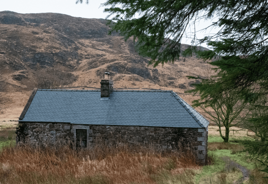
Culsharg bothy. Credit: Andrew Galloway
Despite the ostensible ancestral connections (my father’s family actually came from the North-East of England), I don’t visit Galloway nearly as much as I should. More often than not the rolling hills of the Southern Uplands are passed in the blink of an eye as I speed along the M74 on my way to big Highland names. More fool me. For, as I was recently reminded, the forests of Dumfries & Galloway have much to offer, not least some rugged wilderness with remarkably low footfall. At 843m, Merrick is the highest point on the mainland south of the Central Belt.
The walk to the summit via the Culsharg bothy makes for a fair challenge, particularly in the winter months. For added spice, I elected to head out from the summit into that wilderness to explore the chain of lochs to the east of the big hill. As the light began to fade and the heavens opened I had cause to question my judgment and was reminded to never underestimate the brutal beauty of the Scottish hills, no matter how far south they may be.
Andrew Galloway has mapped the full route to the Culsharg Bothy for The Great Outdoors.
Lingy Hut via Skiddaw
Vivienne Crow enjoys solitude on an overnighter beyond Skiddaw bypassing the basic but secluded Lingy Hut.
START/FINISH: Moot Hall in Keswick town centre, GR NY266234 | MAPS: OS Explorer OL4 and OL5 (1:25k), OS Landranger 90 (1:50k), Harvey 1:25,000 Superwalker Lake District North | DISTANCE: 36km / 22.4 miles | ASCENT: 1,631m / 5,350ft | DURATION: 2 days
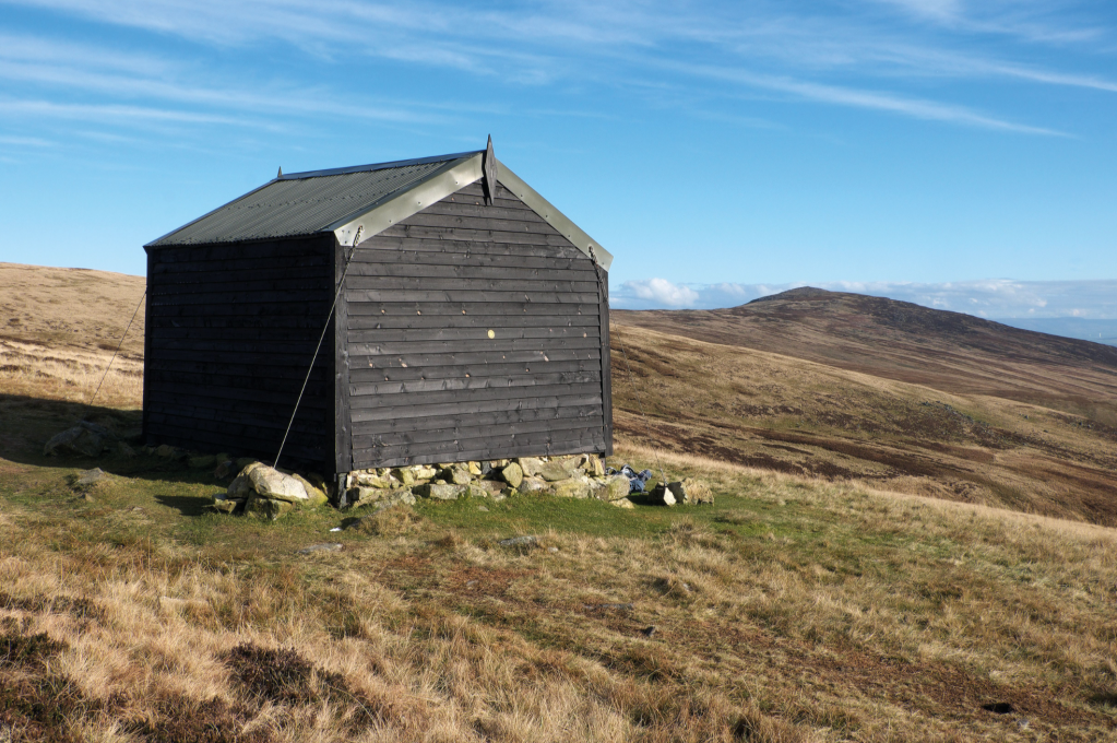
Lingy Hut. Credit: Vivienne Crow
Lingy Hut, sometimes also called Great Lingy Hut, is about as basic as bothies get. Little more than a large wooden shed, it contains a sleeping platform, a spade and a visitors’ book. But it sits in a wonderfully secluded spot, high up in the heart of the Lake District’s quiet Northern Fells. Starting from Keswick, this walk first climbs the busy ‘tourist path’ up Skiddaw before heading for the relative solitude of Great Calva and Knott, two peaks that feel like they’re an awfully long way from anywhere.
After an overnight stop at the hut, nearly 19km into the 36km route and 580m above sea level, the second day is easier. It follows the route of the Cumbria Way through the trench carved by the infant River Caldew and then leaves the fells via a balcony path clinging to the side of the Glenderaterra gap before rejoining the outward route to return to Keswick.
Vivienne Crow has mapped the full route to Lingy Hut for The Great Outdoors.
Arenig Fawr bothy
Featuring an overnight stay in the dinky-but-delightful Arenig Fawr bothy, this hike up Arenig Fawr is a quiet antidote to the crowds of the rest of Eryri National Park (Snowdonia), says James Forrest.
START/FINISH: The car park and layby off the A4212, at the western end of Llyn Celyn (GR: SH845403) | MAPS: OS Explorer OL18 (1:25k), OS Landranger 125 (1:50k), Harvey British Mountain Map Snowdonia South (1:40k) | DISTANCE: 16.5km / 10.3 miles | ASCENT: 682m / 2,238ft | DURATION: 5.5 hours
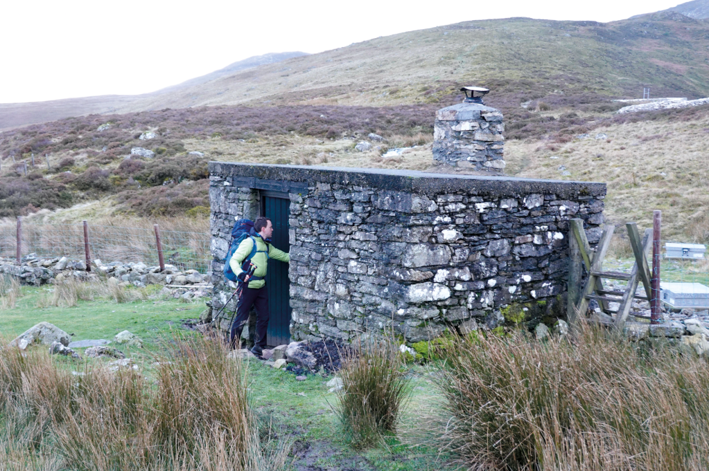
Arenig Fawr Bothy. Credit: James Forrest
A night in a quaint bothy, a quiet hill to climb in the morning, escapism from the mayhem of Snowdonia’s honey-pot areas – this walk has a lot to offer. The Arenigs are a disparate mountain range to the north and west of Bala, a mix of grassy hills, vast bogs and sudden rocky terrain. They feel quiet and wild, and that is their appeal. Day hike options include a two-peak loop of extinct volcano Rhobell Fawr and its remote neighbour Dduallt, or an ascent of pudding-shaped Arenig Fach from Llyn Celyn, but perhaps the Arenigs’ best route is this one up Arenig Fawr.
The highest of the two Arenigs, 854m Fawr is the range’s grandest mountain, with a scenic ascent up its eastern ridge from the shores of Llyn Arenig Fawr. But this route’s real highlight is spending a night in Arenig Fawr bothy. Believed to have been built as a shelter for reservoir construction workers, this tiny stone structure can only sleep two (or three at a push), yet what it lacks in size it makes up for in charm. With the fire roaring and soup bubbling in your pot, it’s a place to relish in the back-to-basics magic of night in the heart of the mountains.
James Forrest has mapped the full route to the Arenig Fawr bothy for The Great Outdoors.
Greg’s Hut, Cross Fell
James Forrest climbs England’s highest peak outside the Lakes, the leviathan of the North Pennines, Cross Fell.
Start/Finish: Small car park next to Kirkland Hall (GR: NY650325) | Maps: OS Explorer OL31 (1:25k), OS Landranger 91 (1:50k) | Distance: 12.6 miles | Ascent: 2,875ft/ | Duration: 7 hours
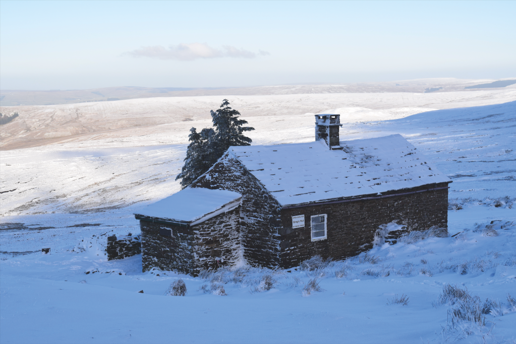
Greg’s Hut. Credit: James Forrest
The leviathan of the North Pennines, Cross Fell (893m/2930ft) is England’s highest mountain outside of the Lake District. It’s a mountain of soft, smooth lines, devoid of the rocky drama of its Lakeland neighbours, but it still has charm, especially if you spend the night at Greg’s Hut, a former miners’ house turned rustic mountain bothy. Named after John ‘Greg’ Gregory, who died in a climbing accident in the Alps, Greg’s Hut is the highest bothy in England.
Cross Fell is also home to the UK’s only named wind – the fierce Helm Wind, a strong north-easterly that batters the mountain’s south-western slopes for much of the year. The route traverses the scree belt at Crossfell Well, a small spring, to emerge at the summit’s fittingly cross-shaped wind shelter, before veering south-east to Tees Head. Next comes an out-and-back on the Pennine Way’s mill flagstones to Little Dun Fell and Great Dun Fell – the latter adorned with a huge, golf ball-shaped radar dome – before looping downhill via Wildboar Scar.
James Forrest has mapped the full route to Greg’s Hut for The Great Outdoors.