
The Cape Wrath Trail is one of Scotland’s best-loved long-distance routes, and the final section to the lighthouse offers the Cape Wrath experience in miniature, argues Alex Roddie.
Many long-distance walkers dream of hiking the Cape Wrath Trail one day. It’s got everything: wildness, mountain views, remote country, and bothies a-plenty. But what if you don’t have two weeks to hike it in one go? Many of the CWT’s sections are of exceptionally high quality, and if you ask me which is best, I might give a different answer each time – they’re all that good. However, if you are looking for a section that is representative of the CWT experience, with a good mixture of grand scenery, legendary bothies, and good old-fashioned off-path navigation, you could do a lot worse than the northernmost stretch. Starting at Blairmore just north of Kinlochbervie, the trail visits Sandwood bay and Strathchailleach bothy before plunging into the wild landscape of Cape Wrath. Round it off with a stay at Kearvaig bothy before returning via ferry to Durness.
Hike to Cape Wrath: route description
START/FINISH: Car park at Blairmore near Kinlochbervie, NC195600, to Kyle of Durness ferry crossing, NC371660 | MAPS: OS 1:25,000 Explorer sheet 446 (Durness & Cape Wrath), OS 1:50,000 Landranger sheet 9 (Cape Wrath), Harvey 1:40,000 XT40 Cape Wrath Trail North | DISTANCE: 41.3km / 25.7 miles | ASCENT: 615m / 2,018ft | DURATION: 2 to 3 days
1. NC204609: Walk along the good track from Blairmore signposted towards Sandwood Bay. You will pass several lochs; the first large one is Loch na Gainimh. The path is very easy at this point with a few gentle undulations.
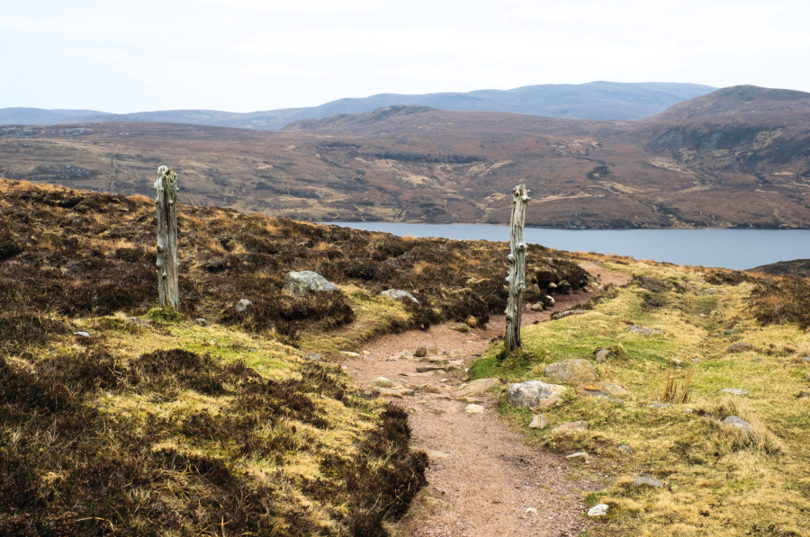
The trail to Sandwood Bay.
Credit: Alex Roddie
2. NC218642: A view opens up ahead towards Sandwood Bay – it’s unmistakable, with a sweeping expanse of sands, and rolling breakers coming in off the sea. The path descends towards the shoreline and soon disappears amongst the dunes. Keep going NE along the beach; it’s usually feasible to walk along the sand except at very high tide. Looking back, there are views of the impressive sea stack of Am Buachaille.
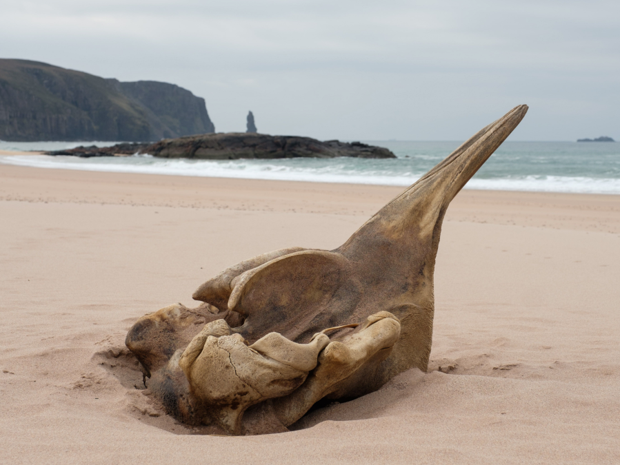
A whale skull on the beach with a view to the sea stack of Am Buachaille.
Credit: Alex Roddie
3. NC225656: You must cross the outflow of Sandwood Loch. In most conditions this crossing is easy, but it can be challenging after heavy rain. On the other side, pick up a vague path climbing steeply to a headland (good views looking back to the beach). The next 11km (6.8 miles) are pathless and require accurate, confident navigation. Follow a gentle ridge SE and then E to reach a 125m spot height (NC235656). From here, navigate NE to reach a boundary; follow this to the bothy at Strathchailleach (NC249658), which makes an excellent place to stay the night.
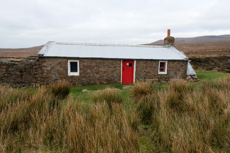
Arrival at Strathchailleach bothy.
Credit: Alex Roddie
4. NC253660: Cross the river immediately outside the bothy and climb boggy slopes gently uphill to reach a broad crest at NC266671 below steeper, rockier terrain; do not climb all the way to Beinn Dearg’s summit. Descend N; cross the Keisgaig River near the outflow from Loch Keisgaig and then climb over the border fence (take care; barbed wire). Do not cross if red flags or red lights are visible – this indicates live firing in the danger area.
The border fence.
Credit: Alex Roddie
5. NC266687: Climb the slopes of Cnoc an Daimh, aiming to veer about 400m W of the summit, then strike N across a broad bealach to Cnoc a’ Ghiubhais (298m, NC266701). From here a long descent due N over boggy terrain, with several stream crossings, will lead directly to the track at NCC266731. Follow this W over several short climbs and descents.

The final north bearing to the lighthouse.
Credit: Alex Roddie
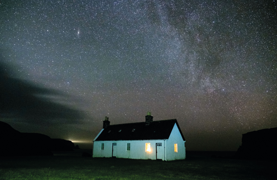
6. NC260758: Reach the lighthouse and outbuildings of Cape Wrath (hidden until you’re almost on top of it). John Ure runs the Ozone Cafe here in the summer months and there is also a bunkhouse. This is the endpoint of the Cape Wrath Trail, with excellent views across the cliffs and out to sea. After soaking in the atmosphere for a while, and maybe meeting a few CWT hikers, return back along the track and follow it for 7km (4.4 miles) until you reach a junction; this is the turnoff to Kearvaig. Make a short descent to the bothy. It’s situated at the head of a welcoming bay (plenty of room for wild camping outside if the bothy is busy).
Kearvaig bothy.
Credit: Alex Roddie
7. NC292727: From the bothy, return uphill to the junction, turn E, and follow the track for 13.3km (8.3 miles) past several small settlements to the jetty at NC371660. Ferries cross the Kyle of Durness from here in the summer; it’s a short walk from the other side to Durness. If the ferry is not running, it’s feasible, but strenuous and time-consuming, to walk around the shores of the Kyle (rough and pathless, with a tidal river crossing).
Further information
PUBLIC TRANSPORT: limited bus service 805 from Inverness to Kinlochbervie near start and Durness near finish; ferry from Cape Wrath to Durness (summer only)
TOURIST INFORMATION: Visit Scotland, 01971 511259.
Cape Wrath is a live MOD firing zone. Call range control on 01412 258135 or 01412 258125 (8am to 5pm) before beginning the hike. If red flags are flying at the border fence, do not enter.
Discover more walks in Scotland as mapped by The Great Outdoors’ expert contributors.


