The Peak District has been in the news in recent years, but making headlines not for its sweeping landscapes or culturally-bubbling communities. Instead, lack of funding for infrastructure and education to facilitate an influx of people who wish to experience our first national park has caused a plethora of problems in the Peak. Gatekeeping and strongly-worded debates on social media ensue and it leaves all those who love and respect the outdoors – and want to share it with all who similarly steward these high places – feeling a little lost. One solution? Avoid the honeypots. Make space for newcomers and explore places you’ve yet to see rather than returning the to natural spots already struggling under the pressure. You might just find a new favourite route. With that said, here are some of the best Peak District walks you may be unaware of – or variations on popular routes you may not have walked.
Main image: Minninglow Hill seen from the High Peak Trail – the circular clump of trees encloses Neolithic burial chambers | Credit: Roger Butler
The best Peak District walks mapped by our experts
This selection of some of the best Peak District walks come with their own mapped route descriptions and .gpx files. Please see the individual route guides for further details. Before you head out on any walk, check the summit forecasts via the MWIS or Met Office, ensure you are kitted up for the conditions and that the route is within your abilities. Familiarise yourself with the Countryside Code and, while out, please respect the environment and communities who call these places home by following the principles of Leave No Trace.
For other routes in the Peak District, have a look at:
- Bonus: lesser-trodden Peak District walks
- Peak District walks for families
- Peak District waterfall walks
- Peak District walk for beginners
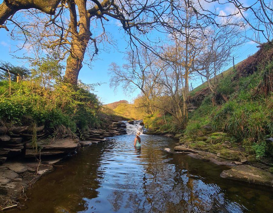
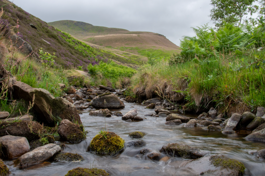
Fairbrook via Oyster Clough Cabin
Francesca Donovan finds a rare pearl of a shelter in Oyster Clough via a two-day route complete with morning waterfall dips in the Peak District.
Start/finish: Snake Pass layby parking (GR: SK 187 864) | Ascent: 1148m / 3,766ft | Distance: 32km/20 miles | Duration: Two days with overnighter | Maps: OS Explorer OL1 – The Peak District, Dark Peak Area (1:25k)
Anyone who says there’s no bothy in the Peak District is technically correct. Yet, I’ve spent many comfortable nights in the shelter of a small stone structure nestled into the pillow of an oyster-shaped clough. Outside, winds whirl around rock formations on Kinder Scout as accounts in the visitors’ book keep you company. If it looks, sounds (and smells!) like a bothy, doesn’t it a bothy make?
The MBA says that bothies – originally accommodation for itinerant workers – evolved into “open shelters…where travellers might have need of four walls and a roof”. By that definition, this shooting cabin is a rare pearl of a bothy.
“Most bothies are at least several hours walk from the public road,” the MBA adds. This is where the Oyster Clough cabin loses points. It is a stone’s throw from Snake Woodlands. Its accessibility has made it a popular haunt for those wanting a taste of bothying. It’s a great place to begin. But, take this two-day route via Cowms Moor, up Fair Brook’s falls and back along the northern edges of Kinder and you may find that away-from-it-all feeling inexorably bound to the beloved bothy.
Read more: the full route description for Fairbrook via Oyster Clough Cabin as mapped by expert Roger Butler
Roystone Rocks and Minninglow
Roger Butler discovers hills and history at Roystone Rocks and Minninglow in the pastoral White Peak.
Start/Finish: Lay-by parking on A515, 1km south of Newhaven, grid ref SK165592 | Map: OS Explorer OL24 (1:25k); OS Landranger 119 (1:50k) | Distance: 13.5km / 8½ miles | Ascent: 280m / 920 feet | Duration: 5 hours
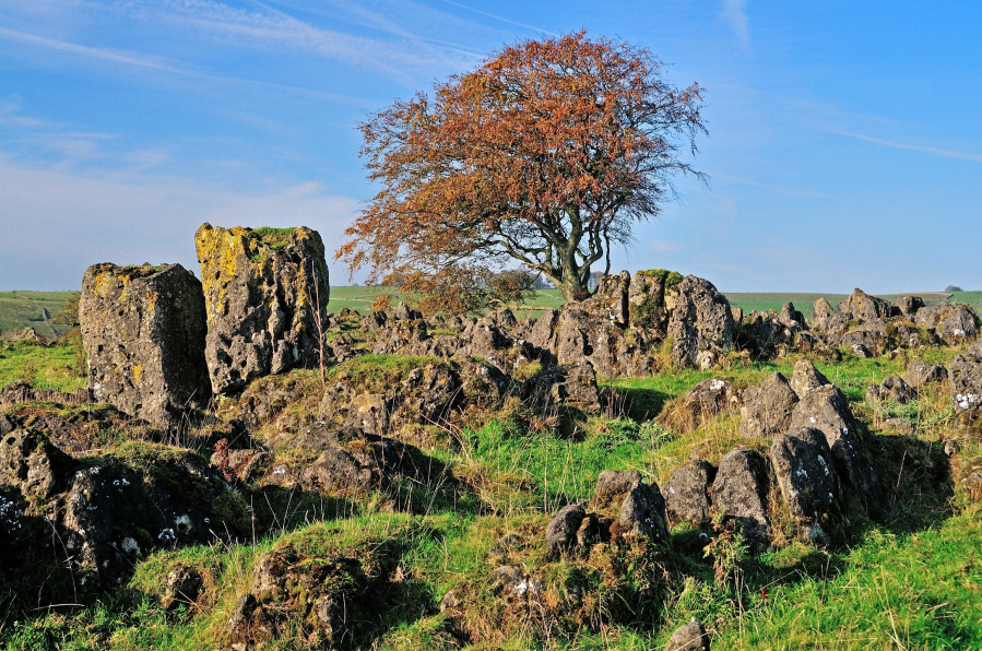
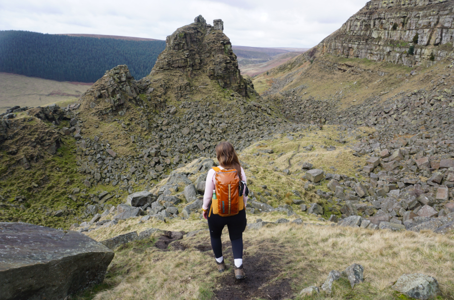
Our hills and dales never fail to surprise and the unexpected stone-splattered top known as Roystone Rocks is unlike anywhere else in the White Peak. This is the sort of place where you are allowed to use your imagination: it’s a ruined village; it’s a mini-Utah; it’s the cover of a famous Pink Floyd LP; it’s a jumble of boulders that must have been melted and moulded by a malevolent wizard. Chequerboard walls and crumpled shallow valleys stretch in every direction but, from the low ragged summit, the real eye-catcher is the distant clump of trees on top of Minninglow Hill. This resembles a crown topped with half a dozen jewels – the result of new planting which encloses tall over-mature beech trees – and it marks the location of important tombs which date back to 4,000BC. Take the path to the top and you’ll soon be asking yourself questions. Who was buried here? Was there a grand ceremonial march up the hillside? And did those Neolithic peoples appreciate the distant views and ever-changing horizons? You certainly will!
Read more: the full route description for Roystone Rocks and Minninglow as mapped by expert Roger Butler
Bleaklow Head & Higher Shelf Moor
Andrew Galloway goes in search of the wreckage of aeroplanes in the Peak District on Bleaklow.
Start/Finish: The crossroads of High Street and Victoria Street in the centre of Glossop. (GR: SK035940) | Distance: 19.5 km (12 miles) | Ascent: 560m | Time: 6 hours | Maps: Ordnance Survey 1:25,000 Peak District OL1
Just a few hundred metres north of the trig-point we found the first piece of twisted aluminium lying against black peat, shining in sunlight as if newly cast. In fact it has lain here, high on the moor near Bleaklow, for seventy years. It takes a while to orientate yourself among the wreckage, spread out over a hundred square metres. The fragments of an aeroplane slowly begin to knit together to form a whole: four engines first, followed by undercarriage, wings, tail-plane. Then you think of the crew. This USAF Boeing RB-29 known as “over-exposed” was taking payroll and mail from Scampton in Lincolnshire to the USAF supply base at Burtonwood near Warrington on 3 November 1948. In poor weather conditions the flight was conducted on instruments, the pilots effectively flying blind. It is thought that the captain understood his position to be further west and began to descend too early to make his approach with disastrous consequences. All thirteen crew were instantly killed as the aircraft ploughed into the ground.
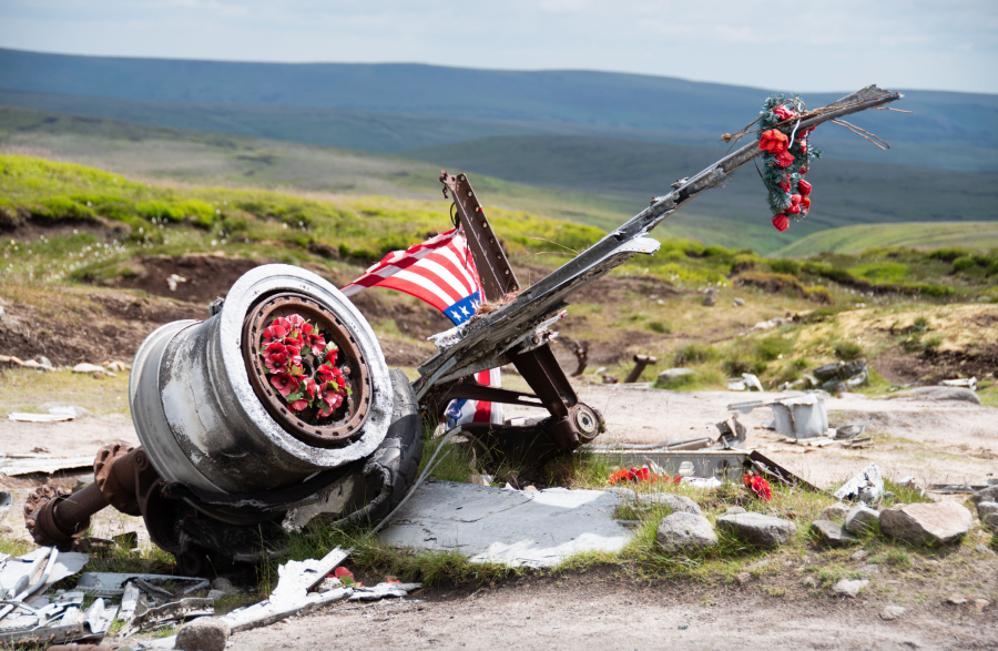
Some years ago, local historian Gerald Scarratt discovered what he thought to be a washer at the crash site. On later inspection, he found it to be a gold ring. It was engraved with the name of the aircraft’s captain, Langdon P. Tanner. Gerald was able to trace the captain’s daughter in America and return the ring to her. Shrouded in history, I have used this route of Bleaklow as part of a navigation course for the Ramblers. Participants are provided with the grid references for the aircraft wrecks, sent to locate them and take a moment to commemorate those lost.
Read more: the full route description for Bleaklow Head & Higher Shelf Moor as mapped by expert Andrew Galloway
Shutlingsloe & Teggs’ Nose
When roads close there are ways via bus to wander on the outskirts of The Peak to the heights of Shutlingsloe, says Francesca Donovan.
Start/Finish: Bus stop at Walker Barn (GR: SJ 955 738) if arriving by public transport or the car park at Tegg’s Nose Country Park (GR: SJ 950 733) if by car | Distance: 16km / 10 miles | Ascent: 637m / 2,090ft | Duration: 5 to 6 hours | Maps: OS Explorer OL24: The Peak District – White Peak Area Buxton, Bakewell, Matlock & Dove Dale (1:25k)
After heavy snowfall, the boundary of the Peak District National Park is notoriously hard to breach from the west with the two main thoroughfares – Snake and Winnats Pass – turning perilous and facing closures in icy conditions. The Cat and Fiddle road, however, is often the first to be greeted by gritters, making Cheshire’s hilly outskirts of The Peak a good (and safe) option for a snow day. While forests and country parks may sound tame, head to Shutlingsloe – locally nicknamed the Cheshire Matterhorn – for some slightly loftier views and to bag a trig overlooking the Cheshire Plain at 506m. The quickest approach is from Macclesfield Forest – look out for the resident red deer – or Wildboarclough but the vistas from Shutlingsloe’s westerly neighbour, Tegg’s Nose, which reach as far as to Eryri on a clear day are worth an extended circular. A popular sledging site, you may also be interested in the Bronze Age burial and the 16th century quarrying historical artefacts. The smattering of pubs and cafes on the return leg of the loop will offer warmth and respite making a snow day the prime time to wander through these otherwise populated woodlands.
In clement weather, if travelling by car, there is plentiful parking in Macclesfield Forest and at Tegg’s Nose.
Read more: the full route description for Shutlingsloe as mapped by expert Francesca Donovan
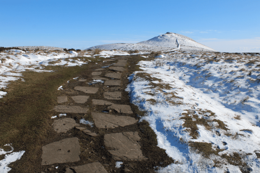
Kinder Low
Francesca Donovan makes a night of it on a Kinder traverse between train stations, taking in the Peak District heights atop Win Hill and Kinder Low out of hours.
Start: Hope train station (GR: SK180 832) | Finish: Chinley train station (GR: SK038 826) | Maps: OS Maps Explorer OL1 – Dark Peak Area (1:25k) | Distance: 25km / 15.5 miles | Duration: 9 hours with an optional overnight camp | Ascent: 858m / 2,815ft
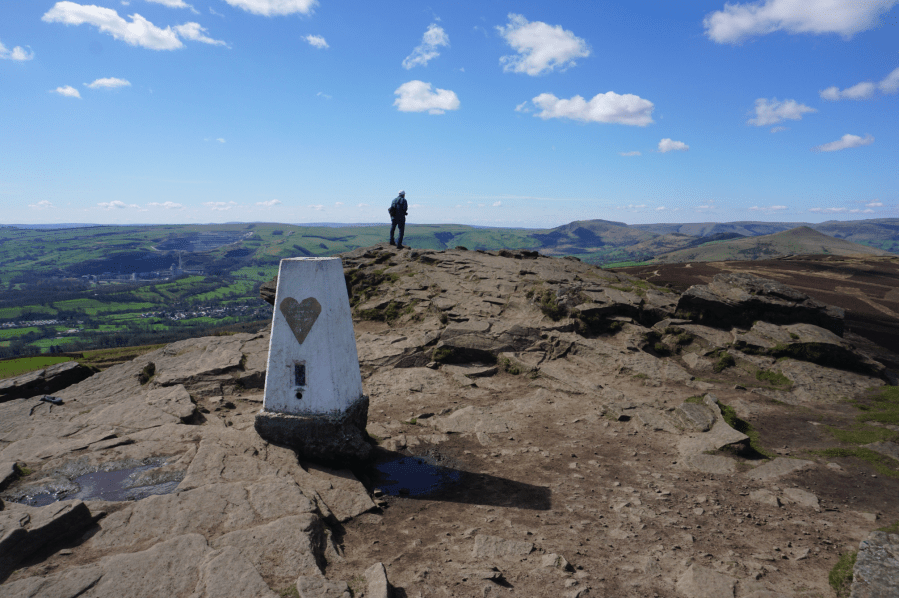
The Kinder plateau comprises some of the highest points and most rugged views in the Peak District (Kinder Scout sits 2,087ft above sea level). You can’t help but admire the natural forces that created the formations of gritstone, akin to a monsters’ graveyard, and the cloughs carved into the side of the landscape. Yet, the walkways that cling to its edge between the Win Hill honeypot and the mouth of Grindsbrook Clough – from which sweaty scramblers are spat out – are also relatively quiet.
We shared hellos with perhaps ten other walkers here even on this (very) Good Friday bank holiday. It’s quite a treat to watch the steady stream of footfall along The Great Ridge from your vantage point of peace. Best of all, this linear train-to-train route allows you to skip dropping down into Edale to face the perils of parking. Kinder’s wide plateaus also provide plentiful space for a tent or two. On this good weather window, complete with sunrise temperature inversion, I knew of at least three other backpackers who chose to pitch on this Peak District high place. But, with enough nooks, crannies and quiet corners for everyone, we barely saw a soul besides one woman bivvying on Kinder Low.
Read more: the full route description for Kinder Low as mapped by expert Francesca Donovan
Rishworth Moor
Andrew Galloway heads just North of the Peak to visit the Pennine Way’s ‘Little House on the Prairie’ – Stott Hall Farm.
Start/Finish: layby on the A672 at Windy Hill GR: SD982141 | Maps: Ordnance Survey 1:25,000 South Pennies OL21 | Distance: 19.5 km (12 miles) | Ascent: 420m | Duration: 5 hours

Stott Hall Farm, the eighteenth-century farmhouse sitting between the lanes of the trans-Pennine M62 motorway, has become an icon of Yorkshire resoluteness, known affectionately by thousands of HGV drivers and fans of the BBC Radio 2 traffic correspondent “Sally Traffic” as “The Little House on the Prairie”. The location of the farm, sandwiched between the carriageways of the motorway, gives the impression of inaccessibility. Determined walkers may, however, approach the dwelling by descending into Booth Dean Clough and passing below the concrete dam of Booth Wood Reservoir. The crest of the dam includes an outlet over which excess water spectacularly cascades one hundred and fifty feet into the clough below, a dramatic sight for motorists on the westbound carriageway of the motorway. Climbing the steep wooded slopes to the south of the dam one is transported into a scene reminiscent of a Philip Pullman novel, where worlds of striking contract exist in parallel. The incumbent tenant of Stott Hall Farm, Paul Thorp, is keen to practice traditional livestock practices that have changed little in three hundred years, not a stone’s throw from one of the busiest motorways in Britain, on which a hundred thousand motorists wiz past the windows of the little house each day.
Read more: the full route description for Stott Hall Farm and Rishworth Moor as mapped by expert Andrew Galloway
The Tower at Alport Castles
Starting your scrambling journey? Take a jaunt up The Tower at Alport Castles for some low-stakes family-friendly fun, says Francesca Donovan.
Start/finish: Haggwater Bridge car park (GR: SK 162 886) | Maps: OS Explorer OL1, The Peak District – Dark Peak area (1:25k) | Distance: 10 miles/17km | Duration: 6 hours | Ascent: 522m/1,713ft
The Peak District isn’t well-known for scrambling. The gritstone edges are favoured instead by boulderers and climbers and scrambling the cloughs up to Kinder can be tricky in wet weather. But there’s another spot where you can cut your teeth; Alport Castles. Here sits The Tower, the geologically impressive consequence of a huge landslide, the causes of which are still debated. This area is well-trodden by walkers who skirt the gritstone boulders lying dormant below Alport Moor, admiring The Tower from afar. Here, you can spend some time with hands on rock. The scrambling is very easy grade 1 (a grade 0.5, if you like) if you stick to the obvious east route up The Tower. Or pick your own route, tackling it straight on for a vertical ascent from Little Moor. Keep an eye out for the resident peregrine falcons who nest in the layers of rock over on the other side of the landslide site. It’s a short scramble but there’s plenty of chance to scamper through the boulder fields before heading back above the farmland with views over to The Great Ridge.
Read more: the full route description for Alport Castles as mapped by expert Francesca Donovan
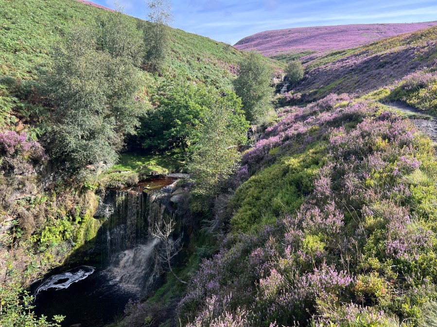
Three Shires Head via Wildboarclough
Start/Finish: Nabb Car Park, Wildboarclough (GR: SJ973 670) | Map: OS Explorer OL24 – White Peak area (1:25k) | Distance: 11km / 6.8 miles | Ascent: 352m / 1155ft | Duration: 3 hours
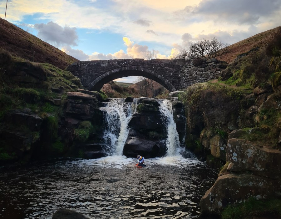
Francesca Donovan visits the popular Peak District picnic spot at Three Shires Head and another hidden waterfall perfect for a more secluded dip. Three Shires Head is beloved for an old stone bridge that crosses over the River Dane where the counties of Staffordshire, Derbyshire and Cheshire meet. Constructed in the 18th century, the bridge had a reputation for lawlessness. Folks would evade capture in their home counties by crossing over to the neighbouring shire. Nowadays, it is a quintessentially peaceful Peak District scene. The waterfall lends a natural soundtrack to this packhorse route for the picnickers who lounge here. It’s a busy dipping spot, especially in summer. But on the other side of Cumberland Clough, past mighty trees, awaits the smaller, secluded waterfall of Wildboardclough. This route will take you to both, along quiet lanes, past the mighty Shutlingsloe, and along wooded trails. Farmland also comprises some of this route and birds nest in the open access land, meaning it’s best to leave your four-legged friends at home.
Read more: the full route description for Three Shires Head as mapped by expert Francesca Donovan
The Edale Skyline
Francesca Donovan guides you on a fine Peak District day challenge taking in the highlights of the Edale Valley bobbing and weaving through honeypots.
Start/finish: Hope train station (GR: SK181832) | Maps: OS Explorer OL24 (1:25k) | Distance: 32km / 20 miles | Ascent: 1096m / 3596ft | Duration: 9-10 hours
The Edale Skyline is the most fun you can have in the Peak District on two feet. That is, if you find admiring sweeping views across the most popular (read: best) hillwalking territory in our first national park fun. This route, which skirts the edges above the entire Edale valley, is a well-loved trail run; but it can be squeezed into a day of walking too. There’s only one sustained ascent and the rest of the walk involves staying high for many undulating miles. It’s well worth the effort. On the Edale skyline, you’ll bag five trig points, enjoy views over the Ladybower Reservoir, encounter fascinating gritstone formations at the edges of the Kinder plateau, and finish along The Great Ridge. Whilst there may be more adrenaline-fuelled routes up to the Kinder Plateau – The Peak’s high point – via cloughs and falls, there are few longer full-day routes in this part of the world. Accessible by public transport into the park, most walkers start in Hope village; but you can easily adjust the route to begin at any stop on the Manchester to Sheffield train line.
Read more: the full route description for The Edale Skyline as mapped by expert Francesca Donovan