

The Nantlle Ridge, on this often-overlooked Snowdonia mountain range, makes for an exciting ridge walk. Here’s our detailed guide to this classic high-level hike.
Just a stone’s throw from the summit of Snowdon, on the western side of the A4085 Beddgelert to Caernarfon Road, lies Snowdonia’s westernmost mountain range; usually referred to as the Nantlle Hills. It’s a fascinating massif made up of a cluster of lofty peaks that form a huge horseshoe around the seldom-visited Cwm Pennant. But it’s the Nantlle ridge that forms the headwall of this remote valley that gets the most attention.
This, along with the dramatically-positioned outlying summit of Y Garn, form the Nantlle Ridge – one of the best little-known mountain walks in Wales. The classic crossing of the ridge is made point-to-point, creating the usual associated logistic issues. But it’s possible to tackle the eastern section of the ridge as a circular route, tagging in the outlying summit of Mynydd Tal-y-Mignedd as an out-and-back diversion. The clamber from Y Garn onto Mynydd Drws-y-coed involves some easy scrambling.
Below is the full route description for this mountain climb.
Hike the Nantlle Ridge: route guide
Start/finish: Rhyd-ddu GR: SH571525 | Maps: OS Explorer OL17 (1:25k), OS Explorer OL17 (1:25k), OS Landranger 115 (1:50k) | Distance: 13km/8 miles | Ascent: 1050m/3445ft | Duration: 6-7 hours | Transport: Buses from Caernarfon and Beddgelert
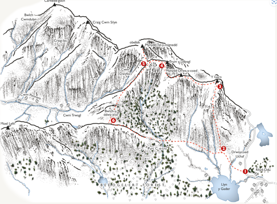
Illustration: Jeremy Ashcroft Maps
START/FINISH: Rhyd-ddu
- GR: SH571525 Cross the road, go through the gate opposite and follow a well-surfaced path over a footbridge to a junction. Turn R, towards to the Drws-y-Coed road to another junction; then, immediately ahead of the road, turn L. Now keep ahead, though a succession of gates, aiming directly towards the peak of Y Garn. After a final gate, the grassy path climbs steeply to a junction.
- SH561523 Turn R to clamber steeply up the flanks of Y Garn, enjoying a short respite at half height. Flank the scree to the L and cross the ladder stile beyond to continue to the summit, which offers amazing views to back to Snowdon and also over a steep drop to the W.
- SH551526 Turn L and drop easily into a shallow saddle, where you join a wall. Keep ahead as the ridge narrows into a rocky arête and continue steeply to the summit. The scrambling is easy: Grade 1 or less, and the awkward sections can be rounded to the L. Stay as close to the crest as is comfortable, eventually crossing a stile at the top to enjoy easy walking to the summit of Mynydd Drws-y-coed.
- SH544516 Keep ahead into the next col and continue up onto the E tip of the table-topped Trum y Ddysgl. At 709m, this is actually the highest point of the walk. Continue across the plateau to the W tip, where you’ll see your descent path breaking L. First, though, make the out-and-back sortie to the obelisk on Mynydd Tal-y-mignedd. To do this, keep ahead to drop into the next col then climb steeply to the top. Return the same way.
- SH543514 Back on Trum y Ddysgl, take the obvious path R and follow the grassy spur down, with the edge of Beddgelert Forest to your L. Continue into the remote Bwlch-y-Ddwy-elor, to a gate on the L. Beneath you now are the atmospheric remnants of the Cwm Trwsgl quarries, definitely worth a visit if you’ve the time and energy.
- SH552503 Go through and drop to meet a forest track, where you turn R and then immediately L. Continue for 300m and keep ahead on a narrow path linking two forest tracks. Cross the second forest track, and keep ahead to follow a narrow path to a gate. Keep ahead now, and follow a clear path around the foot of Mynydd Drws-y-coed to meet your outward path. Turn R to retrace your steps back to Rhyd-Ddu.
If you’d like to see other Eryri (Snowdonia) routes then check out our guide to the best.


