

Rory Calland shares his coast to coast backwards route with us.
Traditionally, a walker will weigh anchor for Wainwright’s Coast to Coast trail in St Bee’s. They’ll climb north onto the headland and take a last look at the Irish Sea before facing up the morning sun and following east. Here, The Great Outdoors humbly makes the case for a reversal of that manoeuvre, whether you are a veteran of the newly minted National Trail or not.
Wainwright claims that the reason his walk is prescribed west-to-east, has to do with the ‘natural’ flow of things from left to right – the way a sentence might plod across a page for instance. That is what he said, but whether we take his word as gospel is another matter. What heed he paid to those devilishly prevailing westerlies, it is hard to say, but walking from east to west, you will find that the wind is ever in your face.
Cumbria was Wainwright’s home, of course, so it was a natural start line for the venerated walker. And perhaps he thought it wise to locate the most physically taxing segment of his trail at the beginning, when the trekker is most limber-legged and hale of heart. Standing on the slipway in Robin Hood’s Bay, you may cast these considerations into the North Sea in favour of one guiding principle, that is: to arrive after many days in England’s most glorified country and have saved that Lakeland as a reward for toil is a very good thing indeed.
You will trample the same grass and rest on the same rocks as the loyal west-to-easter, but with your perspective reversed you will enjoy a unique experience with its own secret views. From Robin Hood’s Bay up onto the fired North York Moors you’ll go, passing those walk-hardened souls on the final stretch with their glassy happiness that could be sadness for trails come to an end. Then it’ll be across the Vale of Mowbray until you meet the Swale by Richmond – she flows east but you’ll continue up into the Yorkshire Dales before you see the unmistakeable shadow of Cumbrian border hills sprawling across the M6. When you reach them you’ll reap your rewards and rally your strength – up and down you’ll go until the world falls away and the Irish Sea lights up the horizon. If standing by the cairn on top of Dent Hill above St Bee’s and seeing the Scottish coast of Dumfries to your north, the Welsh hills to the south, and the Isle of Man clear as day to your heading doesn’t seem like the grandest way to round off a trek of this magnitude, then maybe you’ll be relieved to know you can pick up an excellent pie in Cleator Moor when you come down.
Here’s The Great Outdoors‘ guide to the Coast to Coast trail, featuring helpful tips on the following:
- Route details
- When to go
- Coast to Coast traditions
- Transport
- Accommodation and food
- Essential gear
- Further resources
The Coast to Coast (Backwards): at a glance
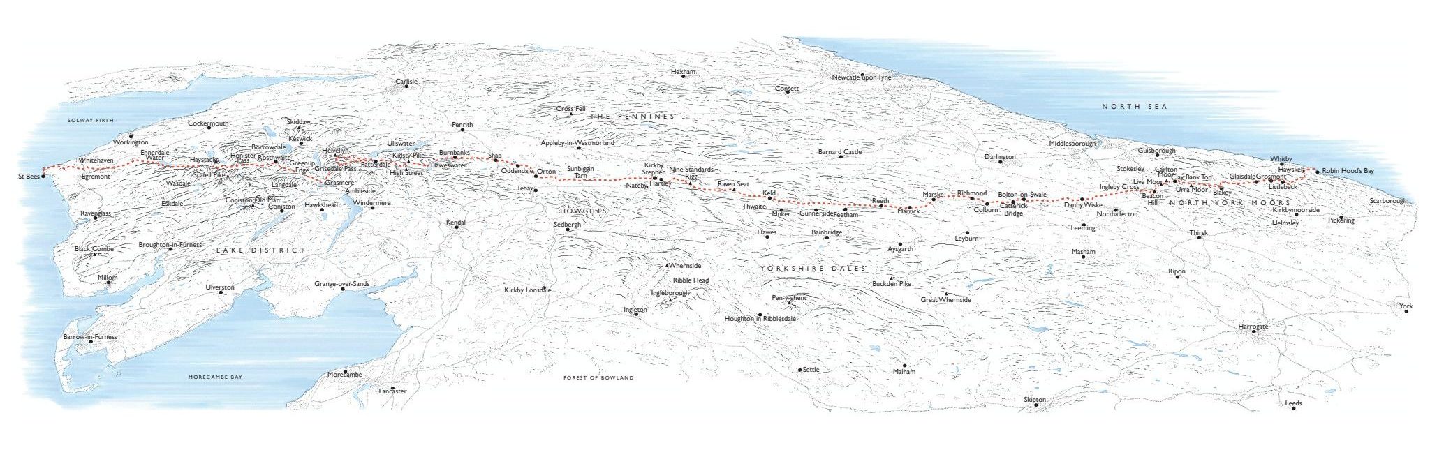
Guide to the Coast to Coast route illustration
START: Robin Hood’s Bay, North Yorkshire | FINISH: St Bees Head Bay, Cumbria| DISTANCE: 293km / 182 miles | ASCENT: 8,000m approx / 26,250ft approx | DURATION: Usually between 12 and 17 days | MAPS: Coast to Coast Path: St Bees to Robin Hood’s Bay by Henry Stedman
The Route
The raison d’etre of the Coast to Coast is its trilogy of national parks – going east to west, the North York Moors, the Yorkshire Dales and Wainwright’s own Lake District. If scale and diversity of landscape are what float your boat then the drama will seem to increase from one to the next.
Depending on how many intrepid detours you wish to take and the pace at which you feel comfortable, most complete the walk over somewhere in the region of two weeks. First, winding up the coastal path, you will acquaint yourself with the view over the North Sea, and as you make your way up onto the moors you will find that sight stalking you for a few days. The deep valley of Littlebeck will shield you from the endless expanses either side of you, and you may make rest there on night one.
Until the new National Trail status yields comprehensive signage, you will have to make do by cobbling together other pre-existing trail markers and keeping an eye on your map. From Littlebeck, the Esk Valley Trail will serve you well through picture-book woodland and steam-train villages.
When you do start to ascend and return to the moor proper, there will be little respite from grouse butts and heather for some days. It can be relentless so look out for snacks left by fellow travellers on the Fat Betty Monument – be sure to swap any takings for something from your own pack lest you be thoroughly hexed.
Your first taste of hill walking will take you to the highest point of the NYM but there are many more fearsome slopes to come. Moving through Belted Galloway country you will feel a palpable sense of satisfaction as you note the blue dot on Google Maps coming to the precipice of your first national park.
Credit: Rory Calland
The Vale of Mowbray will unfurl below you like a portal to a whole new map. What follows was Alfred’s least favourite part of the walk, but there are plenty of curios to be found on this flatter stretch. Visit the Norman Church in Danby Wiske, endowed with original Mouseman furnishings and marked with arrowhead-sharpening scratches from the Battle of the Standard in 1138.
On the approach to Richmond Castle will be your first encounter with the lowly River Swale, your new travelling companion. Though you’ll move in opposite directions you won’t part for some time, and up you go into the Dales.
The proliferation of cricket pitches evoke an ageless Yorkshire that will grow more ancient and stoney on the ascent to Crackpot Hall and Keld. This whistling hamlet hidden in its high valley will prove to be the most secluded spot on the walk where you still have puncher’s chance of getting a bacon butty.
Keld to Kirkby Stephen offers a menu of trails and the chance to pass the Nine Standards of Hartley Fell. Whichever way you choose, today is the day you will stand on high and look to the jagged walls of the Lake District. Say goodbye to Yorkshire and take a final look at the curly-corned Swaledale sheep that have kept you company, then descend into civilisation once more.
The stretch from Kirkby Stephen to the Lake District proper has a tantalising quality. You may find yourself asking for a couple of days whether this counts as it yet, before seeming to reprise the barren heather moorland of North Yorkshire as you near the bridge over the M6. From rainy Shap to Patterdale will offer the first big test of your reserves and the zenith of the regular route, Kidsty Pike. Be on the lookout for red deer and a glimpse of the Irish Sea in Morecambe Bay.
Following the smell of gingerbread to Grasmere, and then back up to Borrowdale you’ll be zig-zagging north and south through a landscape unlike any other in England. From there it’s up the pass to Honister Slate Mine, where the horizon will become less cluttered, the sky opens up, and it feels as if you were climbing towards the edge of the world. Some Galacticos of the Coast to Coast are visible from Grey Knotts, including the highest peak in England, Scafell Pike. But to your west, will be Wainwright’s beloved Haystacks and you can tip your hat to Innominate Tarn, where he is now at rest.
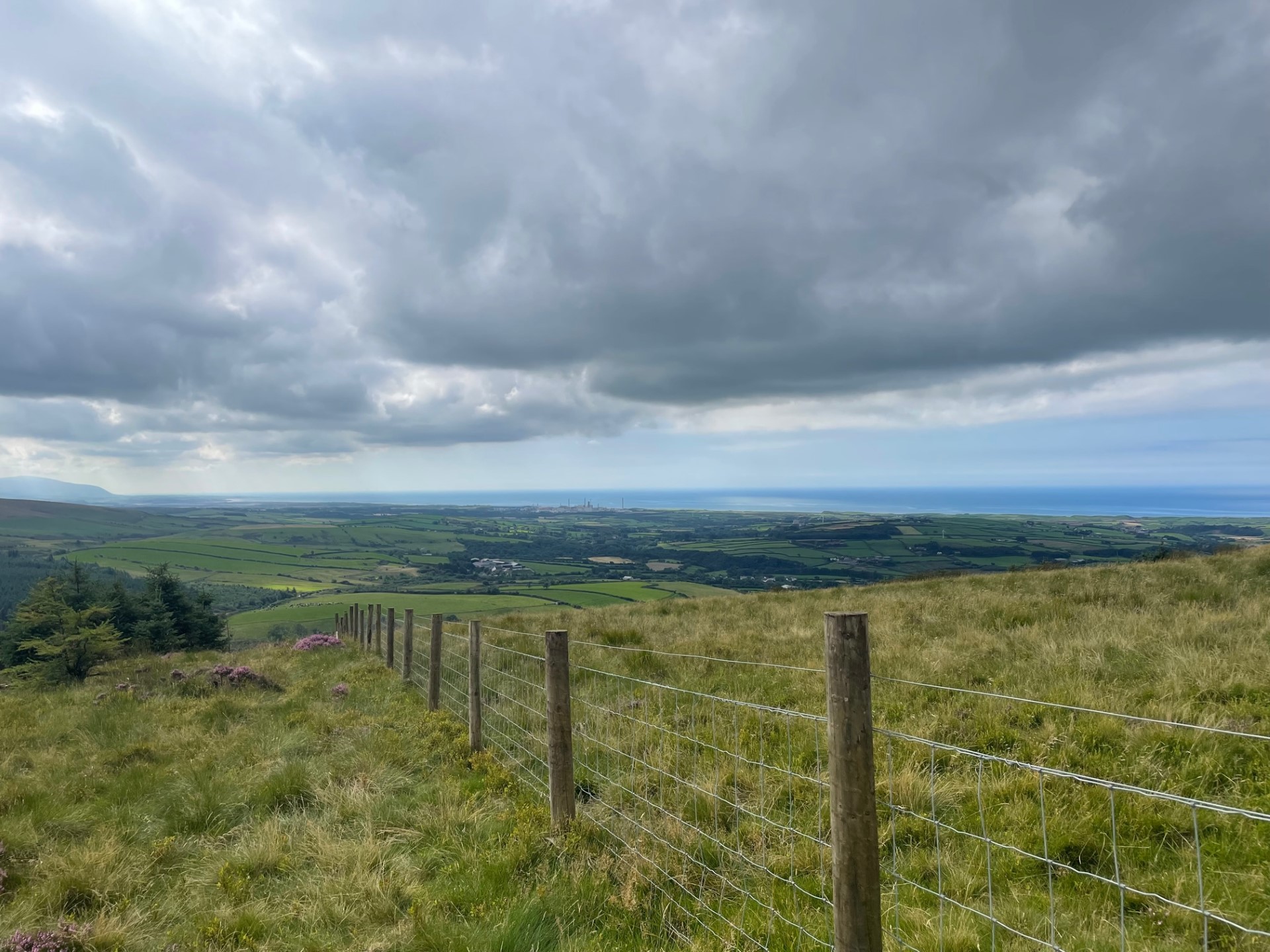
Wheeling around and down to Black Sail, the most remote Youth Hostel in the country, it’s then a long old unchanging forest walk to Ennerdale Water. But don’t take it for granted. Once you start making your way along the lake’s southern shore, the rocks of Cumbria will try their best to leave your feet and ankles with as many bruises and twists as they can. Ennerdale Bridge is where you may well make your final camp with your most vertiginous challenges behind you. A final climb to Dent Hill will produce a revelatory 360-degree view before the victory stomp along the cliffs of St Bee’s Head.
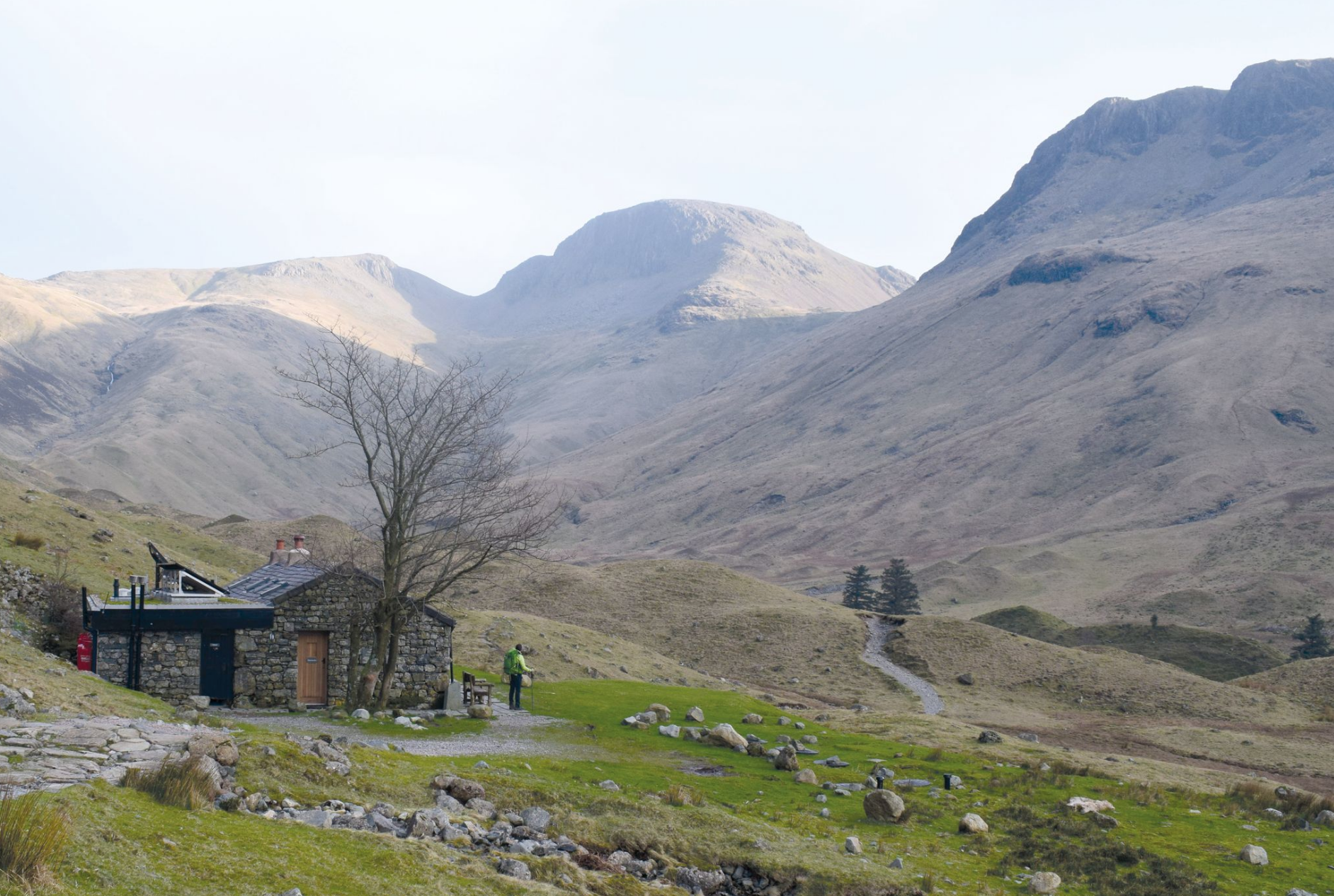
Hiking past Black Sail YHA.
Credit: James Forrest
Traditions
It’s good news for St Bee’s pebble stocks! Each year the legion coast-to-coasters who set off on the usual route, pocket a pebble as they leave, ready to deposit it in the North Sea some days later, so remember to do your bit to restore the balance. Dipping your feet in the sea, socks, clogs and all, is customary at the start and end of the walk.

Coastal walking at St Bees at the start of the Coast to Coast route.
Credit: James Forrest
Accommodation and Food
Campers will find many promising sites along the route. Britain’s fourth-highest pub, The Lion, on Blakey Ridge is something of a fortress and always stuffed with Coast-to-Coasters. Rooms are available but camping outside is a cheap way to do it. You’ll spot it long before you reach the front door, so let the warm hearth and thought of their famous leviathan and chips spur you on. There are, in fact, many pubs that allow camping. Note that the most populous town on trail, Richmond, is a bit of a finicky prospect for campers, so we’d advise stopping a couple of miles back, nearer the barracks of Catterick. The Hildyard Arms is a merry place and accommodating to campers.
In the Lakes, there’s an abundance of Youth Hostels and it’s possible to stay in one every night. Book in advance though if you want even a camping berth.
There will be points on the trail where you feel a long way from anywhere to stock up. Most of the time, you’ll be less than a day away from some sort of shop or pub where you can refuel and restock. What is and isn’t open on any given day however is not an exact science, so make plans and provisions.
Main image and words by Rory Calland


