
Roger Butler takes an atmospheric and witchy walk on the North York Moors
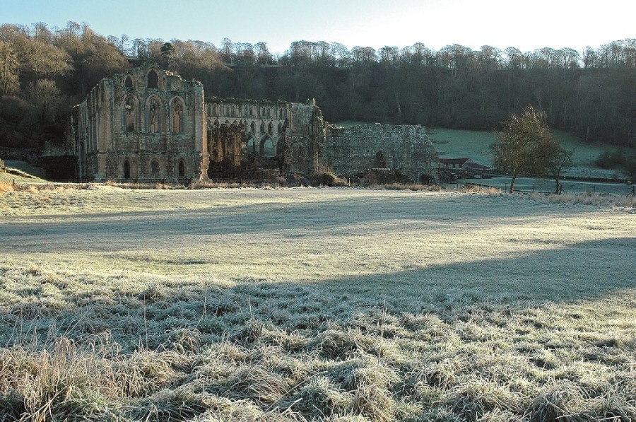
Swirls of gossamer mist hung in the trees and the whole landscape was swathed in shades of blue and grey. Vertical columns of smoke rose from the chimneys of the cottages huddled below the majestic ruins of Rievaulx Abbey. The wintry sunshine had only just reached the valley bottom and clusters of spiders’ webs now shimmered in the silver light.
I followed the line of a short but longlost canal, once built to ferry stone into the monks’ monumental construction site. A track then crossed the River Rye at Bow Bridge and contoured along the twisting dale. Hag Wood made me think of witches and goblins and set me speculating whether it was their antics that had led to the naming of the local farm: Shake Bridge.
A lane eased the way into the scattered hamlet of Hawnby – one of my favourite places in the North York Moors, where red-tiled roofs rise up a steep lane to a tight little crossroads. My path continued north onto Hawnby Hill, a landmark which used to feature on the cover of the OS map (the picture always looked more like the Peak District than the typically heather-clad North York Moors). Its narrowing ridge led onto one of the few proper summits in this part of Yorkshire.
The stark skeleton of a tree clung to an unexpected scree slope, but a series of grassy humps and hollows ensured a comfortable lunch stop. I continued north but then dropped west, through bracken, to cross the Rye once again. An over-engineered footbridge, built in response to a damaging summer flood, arched over the river where a couple of grey wagtails bobbed on the slippery rocks.
Shady woods led towards the top of Stoney Gill Hole from where I turned south across Dale Town Common. The sun was now sinking below Sutton Bank and its low glare made me wish I was carrying ski goggles. I marched quickly along the top of Boltby Scar, pausing only to admire the fading panorama from the trees by High Barn, and then jogged down the lane to Cold Kirby.
It was pretty dark as I cut round the back of the church and realised the mobile was my only source of light from now on. I tried to memorise the route ahead before ghostly creeper-clad trees led down Flassen Dale and on into Nettle Dale. It was pitch dark now and I spent half an hour on the wrong forest track before realising something was amiss. I eventually hit a lane, worked out that I needed to turn left and walked into the night. A farmer stopped to ask if I was lost, but I was able to give him a cheery wave since Rievaulx and the Rye were now only half a mile away.
ROUTE DESCRIPTION
- From Rievaulx village walk NW through fields to Bow Bridge. Cross river and follow track N up valley, passing through three farms to reach lane.
- Turn L for 1.5km, then turn R at junction and follow lane into Hawnby.
- Take path opposite hotel and climb N onto Hawnby Hill, then descend W beyond the summit, past Hill End House, to reach new footbridge over river.
- Take path S for 0.5km then turn R uphill lane/track. At top of hill, by small old quarry, turn S then continue SW over Dale Town Common for 1km to join Cleveland Way
- Walk S to meet lane, turn R downhill for 200m and turn L onto Cleveland Way again. Walk S along top of escarpment for almost 3km.
- Turn L on path to reach road, turn R, after 1km take lane on L to Cold Kirby. Walk past church and continue E on track leading to forested valleys.
- Walk E on Cleveland Way to lane, turn L to cross river then L again to return to start.

Roger Butler takes an atmospheric and witchy walk on the North York Moors
Swirls of gossamer mist hung in the trees and the whole landscape was swathed in shades of blue and grey. Vertical columns of smoke rose from the chimneys of the cottages huddled below the majestic ruins of Rievaulx Abbey. The wintry sunshine had only just reached the valley bottom and clusters of spiders’ webs now shimmered in the silver light.
I followed the line of a short but longlost canal, once built to ferry stone into the monks’ monumental construction site. A track then crossed the River Rye at Bow Bridge and contoured along the twisting dale. Hag Wood made me think of witches and goblins and set me speculating whether it was their antics that had led to the naming of the local farm: Shake Bridge.
A lane eased the way into the scattered hamlet of Hawnby – one of my favourite places in the North York Moors, where red-tiled roofs rise up a steep lane to a tight little crossroads. My path continued north onto Hawnby Hill, a landmark which used to feature on the cover of the OS map (the picture always looked more like the Peak District than the typically heather-clad North York Moors). Its narrowing ridge led onto one of the few proper summits in this part of Yorkshire.
The stark skeleton of a tree clung to an unexpected scree slope, but a series of grassy humps and hollows ensured a comfortable lunch stop. I continued north but then dropped west, through bracken, to cross the Rye once again. An over-engineered footbridge, built in response to a damaging summer flood, arched over the river where a couple of grey wagtails bobbed on the slippery rocks.
Shady woods led towards the top of Stoney Gill Hole from where I turned south across Dale Town Common. The sun was now sinking below Sutton Bank and its low glare made me wish I was carrying ski goggles. I marched quickly along the top of Boltby Scar, pausing only to admire the fading panorama from the trees by High Barn, and then jogged down the lane to Cold Kirby.
It was pretty dark as I cut round the back of the church and realised the mobile was my only source of light from now on. I tried to memorise the route ahead before ghostly creeper-clad trees led down Flassen Dale and on into Nettle Dale. It was pitch dark now and I spent half an hour on the wrong forest track before realising something was amiss. I eventually hit a lane, worked out that I needed to turn left and walked into the night. A farmer stopped to ask if I was lost, but I was able to give him a cheery wave since Rievaulx and the Rye were now only half a mile away.
ROUTE DESCRIPTION
- From Rievaulx village walk NW through fields to Bow Bridge. Cross river and follow track N up valley, passing through three farms to reach lane.
- Turn L for 1.5km, then turn R at junction and follow lane into Hawnby.
- Take path opposite hotel and climb N onto Hawnby Hill, then descend W beyond the summit, past Hill End House, to reach new footbridge over river.
- Take path S for 0.5km then turn R uphill lane/track. At top of hill, by small old quarry, turn S then continue SW over Dale Town Common for 1km to join Cleveland Way
- Walk S to meet lane, turn R downhill for 200m and turn L onto Cleveland Way again. Walk S along top of escarpment for almost 3km.
- Turn L on path to reach road, turn R, after 1km take lane on L to Cold Kirby. Walk past church and continue E on track leading to forested valleys.
- Walk E on Cleveland Way to lane, turn L to cross river then L again to return to start.


