
Geoff Holland heads via the wonderfully-named Bizzle Crags for a delightful walk up The Cheviot
After a late spring the Harthope Valley had just recently sprung into life; burn-hugging trees were in leaf, tiny fronds of bracken were starting to unfurl and large patches of low growing bilberry were spreading their emerald green leaves across sharply-sloping hillsides. It was 7:30 a.m. but already the air was as warm as freshly baked bread as I headed out of the sun-struck valley on a route that would take me to some of the highest and loneliest places in Northumberland.
I could hardly contain my eagerness as I traced the barely-visible Hawsen Burn and then, once across the watershed between Scald and Broadhope Hills, I bounded downhill to the head of the Lambden Valley where carpets of wood sorrel covered the floor of the only plantation I was to pass through all day. The isolated farm of Goldscleugh, tucked beneath the steepsided Preston and Coldburn Hills, showed little signs of life except for the occasional grass-nibbling rabbit as I strode purposefully on to the start of my climb to higher ground.
The base of Bellyside Hill stands next to the point where the Bizzle and Bellyside Burns collide and with the impressive Bizzle Crags in sight I paused for an energy boosting banana before following a rough and rapidly rising track. Ahead, I could see the three stone- and heather-covered humps of Bellyside Hill together with the four distinct strands of the fledgling Goldscleugh Burn, all still holding pockets of late snow.
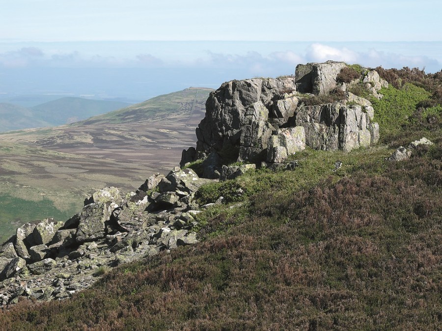
Then onto Bellyside Crag, at 770 metres above sea level the highest crag in the Cheviot Hills. I clambered to the top and, as I looked out from my rocky perch, I could think of nowhere else in Northumberland where there was a greater sense of the vastness of land and sky and a solitary walker’s total insignificance in the hugeness of time and space. I soaked up the solitude.
Pressing on, I drifted across the curved head of the deep cleft of the dramatic Bizzle, an Ice Age relict with steep cliffs and nearvertical screes. With its vast empty bowl and patches of snow it was one of the many highlights of the day but, with more still to come, I plodded on to Braydon Crag, the site of a B17 Flying Fortress crash in 1944.
From there I kept just below the peat line as I wound my way to the splendid stone men on rockshattered West Hill with sensational views into the Hen Hole and across the undulating border into Scotland. As I settled down for a leisurely lunch, the quietness of this airy spot was broken only by the sound of the College Burn tumbling down a series of cascades way below my outstretched legs.
I still had over 10 kilometres to go when I finally dragged myself to my feet and headed along the eastern rim of the Hen Hole to the stone-strewn edge of Auchope Cairn. Here I enjoyed one of the most extensive views in Northumberland before then following the paved Pennine Way over Cairn Hill to the highest point of my walk, Cheviot summit. But with nothing much to detain me in the view department I continued across the vast liquorice-black peat pool-littered plateau to begin my descent to Scald Hill. Once across the top, rather than stay with the popular ‘tourist’ path back to the valley, I headed over quie Blackseat Hill disturbed only by the echoing cries of a couple of vociferous curlews.
ROUTE DESCRIPTION
- Follow path above circular sheep stell with Hawsen Burn on L. Keep with track then head L on subsidiary (green) track to join uphill path. Turn R at fence to stile.
- Cross and follow path downhill. Turn R at track and eventually through plantation. Cross ford and stile next to bushes. Half left to burn, cross and through gates behind buildings. Cross field to road. Turn L.
- Take access road towards Dunsdale. Prior to Bellyside Burn turn L and follow uphill track.
- As path fades turn R across head of burn to reach obvious Bellyside Crag. Continue on intermittent path over head of Bizzle Burn and around upper rim of crags to Braydon Crag.
- Head SSW on intermittent path keeping below peat line to lower crag then SE to large cairns.
- Initially turn NE on intermittent path around rim of Hen Hole to 90 degree turn in College Burn. Cross burn below waterfall and head straight up facing slope to reach paved path then detour R to Auchope Cairn.
- Return along pathway to stiles and L to Cheviot summit. Continue on and cross stile. Follow fence on L over Scald Hill & on to New Burn.
- Turn R on track over then down Blackseat Hill. At road turn L.

Geoff Holland heads via the wonderfully-named Bizzle Crags for a delightful walk up The Cheviot
After a late spring the Harthope Valley had just recently sprung into life; burn-hugging trees were in leaf, tiny fronds of bracken were starting to unfurl and large patches of low growing bilberry were spreading their emerald green leaves across sharply-sloping hillsides. It was 7:30 a.m. but already the air was as warm as freshly baked bread as I headed out of the sun-struck valley on a route that would take me to some of the highest and loneliest places in Northumberland.
I could hardly contain my eagerness as I traced the barely-visible Hawsen Burn and then, once across the watershed between Scald and Broadhope Hills, I bounded downhill to the head of the Lambden Valley where carpets of wood sorrel covered the floor of the only plantation I was to pass through all day. The isolated farm of Goldscleugh, tucked beneath the steepsided Preston and Coldburn Hills, showed little signs of life except for the occasional grass-nibbling rabbit as I strode purposefully on to the start of my climb to higher ground.
The base of Bellyside Hill stands next to the point where the Bizzle and Bellyside Burns collide and with the impressive Bizzle Crags in sight I paused for an energy boosting banana before following a rough and rapidly rising track. Ahead, I could see the three stone- and heather-covered humps of Bellyside Hill together with the four distinct strands of the fledgling Goldscleugh Burn, all still holding pockets of late snow.
Then onto Bellyside Crag, at 770 metres above sea level the highest crag in the Cheviot Hills. I clambered to the top and, as I looked out from my rocky perch, I could think of nowhere else in Northumberland where there was a greater sense of the vastness of land and sky and a solitary walker’s total insignificance in the hugeness of time and space. I soaked up the solitude.
Pressing on, I drifted across the curved head of the deep cleft of the dramatic Bizzle, an Ice Age relict with steep cliffs and nearvertical screes. With its vast empty bowl and patches of snow it was one of the many highlights of the day but, with more still to come, I plodded on to Braydon Crag, the site of a B17 Flying Fortress crash in 1944.
From there I kept just below the peat line as I wound my way to the splendid stone men on rockshattered West Hill with sensational views into the Hen Hole and across the undulating border into Scotland. As I settled down for a leisurely lunch, the quietness of this airy spot was broken only by the sound of the College Burn tumbling down a series of cascades way below my outstretched legs.
I still had over 10 kilometres to go when I finally dragged myself to my feet and headed along the eastern rim of the Hen Hole to the stone-strewn edge of Auchope Cairn. Here I enjoyed one of the most extensive views in Northumberland before then following the paved Pennine Way over Cairn Hill to the highest point of my walk, Cheviot summit. But with nothing much to detain me in the view department I continued across the vast liquorice-black peat pool-littered plateau to begin my descent to Scald Hill. Once across the top, rather than stay with the popular ‘tourist’ path back to the valley, I headed over quie Blackseat Hill disturbed only by the echoing cries of a couple of vociferous curlews.
ROUTE DESCRIPTION
- Follow path above circular sheep stell with Hawsen Burn on L. Keep with track then head L on subsidiary (green) track to join uphill path. Turn R at fence to stile.
- Cross and follow path downhill. Turn R at track and eventually through plantation. Cross ford and stile next to bushes. Half left to burn, cross and through gates behind buildings. Cross field to road. Turn L.
- Take access road towards Dunsdale. Prior to Bellyside Burn turn L and follow uphill track.
- As path fades turn R across head of burn to reach obvious Bellyside Crag. Continue on intermittent path over head of Bizzle Burn and around upper rim of crags to Braydon Crag.
- Head SSW on intermittent path keeping below peat line to lower crag then SE to large cairns.
- Initially turn NE on intermittent path around rim of Hen Hole to 90 degree turn in College Burn. Cross burn below waterfall and head straight up facing slope to reach paved path then detour R to Auchope Cairn.
- Return along pathway to stiles and L to Cheviot summit. Continue on and cross stile. Follow fence on L over Scald Hill & on to New Burn.
- Turn R on track over then down Blackseat Hill. At road turn L.


