

Sarah Ryan spends a day exploring one of Britain’s most peculiar islands
Marooned by the tide, I gazed out across the rippling Bristol Channel to Cardiff. Those little wavelets ruffling the surface were deceptive: the tides around Steep Holm are capricious and powerful and are one of the reasons it has retained its wildness. With only a whisper of bad weather the speedboat service will be cancelled and another day wraps Steep Holm in wild seclusion. Twenty trips have been planned for this year, but not all of them will take place.
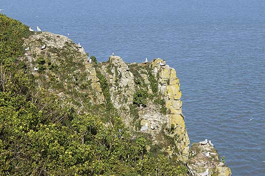
At about 500m by 1km across, the island is a protuberance of what was once an extremity of the Mendip Hills. Steep Holm and its neighbour Flat Holm are all that remain of this flooded plain. In early summer lesser blackbacked and herring gulls move in and the island is scattered with nests, tucked into the grasses and along the edges of paths like Easter baskets, each one containing a clutch of two or three mottled eggs, while cormorants roost on the limestone cliffs.
Our intrusion that day didn’t go unnoticed. We were warned to wear hats and find a stick to wave at the gulls, vicious and judicious wardens of their nests. It was sage advice and soon almost every visitor had grasped a stalk of the ubiquitous Alexander and was patrolling the island, stems aloft. At our feet, sun-fluffed chicks scurried in the undergrowth while others battled from the egg to lie damp and panting in a nest of dirt and leaves.
The wildness of the island is enforced by its infrequent access and the unreliability of the weather but it’s also protected by the Trust who own it. What you find on landing is something akin to a secret garden. Each trip allows roughly 12 hours ashore, which at first seems like a large amount of time for only around 50 acres of space, but with every loop of the island something new is discovered. As the tide draws back from the beach it reveals a goose-neck swerve of pebbles where grey seals can be seen reclining on the stones. Muntjac deer roam through the foliage which scents the air with a humid, green fragrance, perfumed in places by the musky wallflower or the oily camphor tang of crushed Alexander. The wild peony, which has only naturalised on this island, blooms in fuchsia clumps.
At strategic locations around the island are World War Two batteries, observation points and subterranean shell and cartridge stores. Borrow a torch from the visitor centre in the converted Victorian Barracks and descend crumbling steps to the cool and derelict stores where door arches are stencilled in white paint with their long since removed contents. The island contains a fascinating history of Victorian warreners, Augustinian monks and WWII resistance along with its rich haul of plants and creatures.
When the boat came to collect us in the early evening I was already planning a return visit in autumn to a quieter island enhanced by all the aspects of its season, visited briefly by migrating birds.
ROUTE DESCRIPTION
- Ascend the path N from the landing bay past the ruined inn. Just before the remains of Cliff Cottage the path turns S. After 100m it turns inland to a junction at an old battery.
- Follow the path W along the S coast of the island to the barracks. This trail then continues, following the perimeter of the island.
- An alternate path beside the Barracks Visitor Centre takes you N to the centre of the island. Bear E to reach the trig point at 79m. Continuing E will lead you to the priory and farmhouse ruins and back to the easternmost battery.
- At the SE edge of the island a steep scree-lined slope leads down to the south landing and Calf Rock is visible at low tide.

Sarah Ryan spends a day exploring one of Britain’s most peculiar islands
Marooned by the tide, I gazed out across the rippling Bristol Channel to Cardiff. Those little wavelets ruffling the surface were deceptive: the tides around Steep Holm are capricious and powerful and are one of the reasons it has retained its wildness. With only a whisper of bad weather the speedboat service will be cancelled and another day wraps Steep Holm in wild seclusion. Twenty trips have been planned for this year, but not all of them will take place.
At about 500m by 1km across, the island is a protuberance of what was once an extremity of the Mendip Hills. Steep Holm and its neighbour Flat Holm are all that remain of this flooded plain. In early summer lesser blackbacked and herring gulls move in and the island is scattered with nests, tucked into the grasses and along the edges of paths like Easter baskets, each one containing a clutch of two or three mottled eggs, while cormorants roost on the limestone cliffs.
Our intrusion that day didn’t go unnoticed. We were warned to wear hats and find a stick to wave at the gulls, vicious and judicious wardens of their nests. It was sage advice and soon almost every visitor had grasped a stalk of the ubiquitous Alexander and was patrolling the island, stems aloft. At our feet, sun-fluffed chicks scurried in the undergrowth while others battled from the egg to lie damp and panting in a nest of dirt and leaves.
The wildness of the island is enforced by its infrequent access and the unreliability of the weather but it’s also protected by the Trust who own it. What you find on landing is something akin to a secret garden. Each trip allows roughly 12 hours ashore, which at first seems like a large amount of time for only around 50 acres of space, but with every loop of the island something new is discovered. As the tide draws back from the beach it reveals a goose-neck swerve of pebbles where grey seals can be seen reclining on the stones. Muntjac deer roam through the foliage which scents the air with a humid, green fragrance, perfumed in places by the musky wallflower or the oily camphor tang of crushed Alexander. The wild peony, which has only naturalised on this island, blooms in fuchsia clumps.
At strategic locations around the island are World War Two batteries, observation points and subterranean shell and cartridge stores. Borrow a torch from the visitor centre in the converted Victorian Barracks and descend crumbling steps to the cool and derelict stores where door arches are stencilled in white paint with their long since removed contents. The island contains a fascinating history of Victorian warreners, Augustinian monks and WWII resistance along with its rich haul of plants and creatures.
When the boat came to collect us in the early evening I was already planning a return visit in autumn to a quieter island enhanced by all the aspects of its season, visited briefly by migrating birds.
ROUTE DESCRIPTION
- Ascend the path N from the landing bay past the ruined inn. Just before the remains of Cliff Cottage the path turns S. After 100m it turns inland to a junction at an old battery.
- Follow the path W along the S coast of the island to the barracks. This trail then continues, following the perimeter of the island.
- An alternate path beside the Barracks Visitor Centre takes you N to the centre of the island. Bear E to reach the trig point at 79m. Continuing E will lead you to the priory and farmhouse ruins and back to the easternmost battery.
- At the SE edge of the island a steep scree-lined slope leads down to the south landing and Calf Rock is visible at low tide.


