
This was simply one of those days. One of those great, life-affirming, joyful, grin-inducing days that come along a couple of times a year. It had all the tangible aspects that contribute to memorable excursions into the hills: the weather was cold but clear, there was a scarcity of other people, significant height, the requirement for ice axe and crampons, a hint of danger and something new.
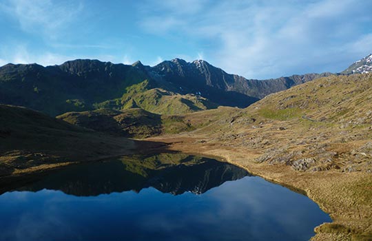
I’d just finished a two-day winter skills course at Plas y Brenin, the National Mountain Centre in Snowdonia, and I was keen to get some more practice in with my winter kit while I was in the area. The day before had been appalling, and the forecast continued to be poor so I’d planned a lowlevel walk, but awoke to clear skies and a full view of the Snowdon Horseshoe from the dining room at ‘the Brenin’. Y Lliwedd, black and domineering, dominated the view. There was my destination. I hitched to Pen-y-Pass, and followed the Miners’ Track to the eastern end of Llyn Llydaw. I veered off south, climbing steeply up Y Lliwedd. Verglas coated the rocks and frost made the pebbles slippery until I emerged into the morning sunlight. Wales spread out before me on the clearest day I’ve ever seen up here.
Y Lliwedd has three tops: Lliwedd Bach, and the East Peak and West Peak. They are surprisingly distinct and each more demanding. A clear path winds around the southern side, but it’s worth climbing up to the ridge to experience the horrifying drop into what is almost perpetual darkness. George Mallory famously used it in training for Everest, and it was used again before the successful 1953 expedition.
The descent from the West Peak was scrambly, slow and a bit unpleasant, but the steep climb back up to Snowdon not as bad as it looks. Towards the top I put on my crampons and relished jutting in my spikes.
I stomped my way to the summit, having watched three lads struggle up the steep snow without spikes. However it was then that I saw a kerfuffle at the top of the Pyg Track and someone panicking up the snow without aids, having just slipped 60 metres.
He was five metres from a sheer drop and a very bad day. I’d planned a ‘half horseshoe’, returning via the Pyg Track, but there was a six-metre drop to the snow at the top of the track and, alone, I decided it wasn’t worth it. Instead, I headed in the direction of Pete’s Eats in Llanberis, via more snow, more steep drops, and more underprepared people struggling across snowfields in trainers.
The new rescue helicopter circled overhead. I later discovered a woman, without ice axe and crampons, had fallen but survived. And in the four days between my walk and writing this, another two people have fallen on this spot, and half a dozen in this year alone. I was grateful for my equipment, and grateful for my winter skills course, and more than ever grateful for the mountain rescue teams.
ROUTE DESCRIPTION
- From the Pen-y-Pass car park, follow the Miners’ Track to Llyn Llydaw.
- At the building, follow the clear path SW and steeply up to the ridge (marked Lliwedd Bach on the Explorer map).Follow the path just to the south sideof the ridge over the East Peak and West Peak.
- Carefully descend down the West Peak to the col. There’s no clear path, but nearer the ridge is easier. In poor weather and snow, navigation and descent could be difficult.
- At the top of the Watkin Path, follow the clear path NW steeply up to the ridge just south of Snowdon summit. It’s steep in places and if there’s any snow at all, ice axe and crampons are essential. Follow the ridge NE past the café to the summit.
- Although I planned to return down the Miners’ Track, it was dangerous, so I followed the ridge (beware of cornices) and the signs to the Llanberis Path.
- From there, it’s an easy clear walk down to Llanberis. If there’s snow, you’ll definitely need an ice axe and crampons above Clogwyn Coch.

This was simply one of those days. One of those great, life-affirming, joyful, grin-inducing days that come along a couple of times a year. It had all the tangible aspects that contribute to memorable excursions into the hills: the weather was cold but clear, there was a scarcity of other people, significant height, the requirement for ice axe and crampons, a hint of danger and something new.
I’d just finished a two-day winter skills course at Plas y Brenin, the National Mountain Centre in Snowdonia, and I was keen to get some more practice in with my winter kit while I was in the area. The day before had been appalling, and the forecast continued to be poor so I’d planned a lowlevel walk, but awoke to clear skies and a full view of the Snowdon Horseshoe from the dining room at ‘the Brenin’. Y Lliwedd, black and domineering, dominated the view. There was my destination. I hitched to Pen-y-Pass, and followed the Miners’ Track to the eastern end of Llyn Llydaw. I veered off south, climbing steeply up Y Lliwedd. Verglas coated the rocks and frost made the pebbles slippery until I emerged into the morning sunlight. Wales spread out before me on the clearest day I’ve ever seen up here.
Y Lliwedd has three tops: Lliwedd Bach, and the East Peak and West Peak. They are surprisingly distinct and each more demanding. A clear path winds around the southern side, but it’s worth climbing up to the ridge to experience the horrifying drop into what is almost perpetual darkness. George Mallory famously used it in training for Everest, and it was used again before the successful 1953 expedition.
The descent from the West Peak was scrambly, slow and a bit unpleasant, but the steep climb back up to Snowdon not as bad as it looks. Towards the top I put on my crampons and relished jutting in my spikes.
I stomped my way to the summit, having watched three lads struggle up the steep snow without spikes. However it was then that I saw a kerfuffle at the top of the Pyg Track and someone panicking up the snow without aids, having just slipped 60 metres.
He was five metres from a sheer drop and a very bad day. I’d planned a ‘half horseshoe’, returning via the Pyg Track, but there was a six-metre drop to the snow at the top of the track and, alone, I decided it wasn’t worth it. Instead, I headed in the direction of Pete’s Eats in Llanberis, via more snow, more steep drops, and more underprepared people struggling across snowfields in trainers.
The new rescue helicopter circled overhead. I later discovered a woman, without ice axe and crampons, had fallen but survived. And in the four days between my walk and writing this, another two people have fallen on this spot, and half a dozen in this year alone. I was grateful for my equipment, and grateful for my winter skills course, and more than ever grateful for the mountain rescue teams.
ROUTE DESCRIPTION
- From the Pen-y-Pass car park, follow the Miners’ Track to Llyn Llydaw.
- At the building, follow the clear path SW and steeply up to the ridge (marked Lliwedd Bach on the Explorer map).Follow the path just to the south sideof the ridge over the East Peak and West Peak.
- Carefully descend down the West Peak to the col. There’s no clear path, but nearer the ridge is easier. In poor weather and snow, navigation and descent could be difficult.
- At the top of the Watkin Path, follow the clear path NW steeply up to the ridge just south of Snowdon summit. It’s steep in places and if there’s any snow at all, ice axe and crampons are essential. Follow the ridge NE past the café to the summit.
- Although I planned to return down the Miners’ Track, it was dangerous, so I followed the ridge (beware of cornices) and the signs to the Llanberis Path.
- From there, it’s an easy clear walk down to Llanberis. If there’s snow, you’ll definitely need an ice axe and crampons above Clogwyn Coch.


