

Fiona Barltrop escapes the bikers to enjoy a superb day’s walk along the top of the Eglwyseg escarpment
The massed ranks of motorbikes outside the Ponderosa Café at the top of the Horseshoe Pass was an unexpected and, I confess, far from welcome spectacle. Unbeknown to me at the time, this is a famous meeting place for motorcycle enthusiasts, especially in the summer – apparently there have been up to 3,000 here at one turnout. If it was noisy today with mere hundreds gathered, I dread to think what it can be like… But I’d come here to walk, and walk I would, but with a change of plan. Instead of the Llantysilio Mountain ridge walk, with the views on the way up to Moel y Faen spoilt by all those bikes below (and even the possibility of encountering illegal off-road motorbikes along the top, about which I’d been warned – a considerable problem in the area) I decided to head in the other direction.
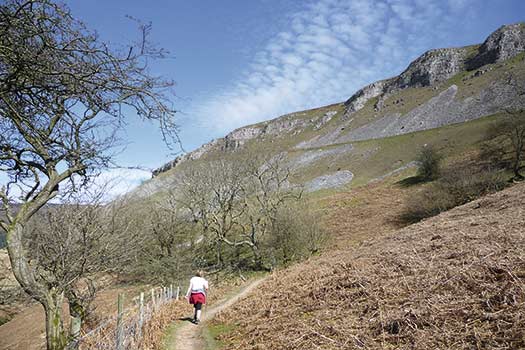
Within a few minutes I was in another world walking down a delightful grassy track following a stretch of the Clwydian Way, a 122-mile route through North Wales, waymarked with a distinctive white disc featuring the buzzard. Not a soul in sight and the only sound that of the breeze and birdsong. Beyond Bryn-yr-Odyn I continued on the Clwydian Way along the bracken and gorse-covered hillsides, before long enjoying views towards the impressive Eglwyseg escarpment. (And in case you’re wondering, it’s pronounced something like Ig-loo-sig.) As anyone who has walked the Offa’s Dyke Path will know, these dramatic limestone cliffs are one of the highlights of the route. I’d not been back here since my own teenage expedition all those years ago and was looking forward to walking that section of the Path which runs below them again.
Leaving the Clwydian Way I turned off left down a path to a track, then left again to a lane, and left once more to memorably named World’s End. (Actually, I had a personal reason for coming here, too, since I live in a neighbourhood in very different part of the country with exactly the same name – so could claim to have been from one end of the world to another…) Joining the Offa’s Dyke Path at the bend in the road, I turned off to head southwards intending to follow the Path across the scree slopes of the western scarp of Eglwseg Mountain, but a chance encounter changed my mind. “There’s a better route with much better views from the top of the escarpment,” a passing walker commented. “Carry on until you reach a marker post and a path turning back left uphill, and that’ll lead you on up to the top.” With no path shown along the crest of the escarpment on either the Explorer or Landranger map, I hadn’t been aware there was a route. But it proved to be excellent advice. With spectacular views over the edge of the limestone cliffs on one side, moorland on the other and none but sheep for company on this fine sunny afternoon, it was walking at its best.
I continued along the top of Trevor Rocks enjoying good views of Dinas Bran below, the Vale of Llangollen and the Berwyns beyond, then descended to the road, rejoining the Offa’s Dyke Path. A detour to climb to the top of Dinas Bran – crowned by its picturesque ruins, a medieval castle sited within an Iron Age hill fort – couldn’t be resisted. Another glorious viewpoint. Back on the Offa’s Dyke Path, I followed it northwards, turning off left beyond Rock Farm, then back up the old Horseshoe Pass road to the now deserted Ponderosa. The long uphill trudge at the end of the day was a price worth paying for such a splendid day’s walk.
ROUTE DESCRIPTION
- Take the minor road behind Ponderosa and soon turn off L down the Clwydian Way. Follow this via Bryn-yr-Odyn and Cae’r Hafod. Turn off L down a footpath to a track, L again and L along the road to World’s End.
- Turn off R along Offa’s Dyke Path (ODP). Before reaching the scree turn back L uphill at a marker post to follow the permissive path up to the top of the escarpment and head S along the waymarked path keeping close to the edge. Continue along the escarpment of Trevor Rocks and down to the road.
- Turn R along the road – route of the ODP – and soon L for the detour to the top of Dinas Bran.
- Retrace steps and rejoin the ODP, continuing on the road past Rock Farm.
- Turn L and R just before the A542 and follow the road back uphill to Ponderosa.

Fiona Barltrop escapes the bikers to enjoy a superb day’s walk along the top of the Eglwyseg escarpment
The massed ranks of motorbikes outside the Ponderosa Café at the top of the Horseshoe Pass was an unexpected and, I confess, far from welcome spectacle. Unbeknown to me at the time, this is a famous meeting place for motorcycle enthusiasts, especially in the summer – apparently there have been up to 3,000 here at one turnout. If it was noisy today with mere hundreds gathered, I dread to think what it can be like… But I’d come here to walk, and walk I would, but with a change of plan. Instead of the Llantysilio Mountain ridge walk, with the views on the way up to Moel y Faen spoilt by all those bikes below (and even the possibility of encountering illegal off-road motorbikes along the top, about which I’d been warned – a considerable problem in the area) I decided to head in the other direction.
Within a few minutes I was in another world walking down a delightful grassy track following a stretch of the Clwydian Way, a 122-mile route through North Wales, waymarked with a distinctive white disc featuring the buzzard. Not a soul in sight and the only sound that of the breeze and birdsong. Beyond Bryn-yr-Odyn I continued on the Clwydian Way along the bracken and gorse-covered hillsides, before long enjoying views towards the impressive Eglwyseg escarpment. (And in case you’re wondering, it’s pronounced something like Ig-loo-sig.) As anyone who has walked the Offa’s Dyke Path will know, these dramatic limestone cliffs are one of the highlights of the route. I’d not been back here since my own teenage expedition all those years ago and was looking forward to walking that section of the Path which runs below them again.
Leaving the Clwydian Way I turned off left down a path to a track, then left again to a lane, and left once more to memorably named World’s End. (Actually, I had a personal reason for coming here, too, since I live in a neighbourhood in very different part of the country with exactly the same name – so could claim to have been from one end of the world to another…) Joining the Offa’s Dyke Path at the bend in the road, I turned off to head southwards intending to follow the Path across the scree slopes of the western scarp of Eglwseg Mountain, but a chance encounter changed my mind. “There’s a better route with much better views from the top of the escarpment,” a passing walker commented. “Carry on until you reach a marker post and a path turning back left uphill, and that’ll lead you on up to the top.” With no path shown along the crest of the escarpment on either the Explorer or Landranger map, I hadn’t been aware there was a route. But it proved to be excellent advice. With spectacular views over the edge of the limestone cliffs on one side, moorland on the other and none but sheep for company on this fine sunny afternoon, it was walking at its best.
I continued along the top of Trevor Rocks enjoying good views of Dinas Bran below, the Vale of Llangollen and the Berwyns beyond, then descended to the road, rejoining the Offa’s Dyke Path. A detour to climb to the top of Dinas Bran – crowned by its picturesque ruins, a medieval castle sited within an Iron Age hill fort – couldn’t be resisted. Another glorious viewpoint. Back on the Offa’s Dyke Path, I followed it northwards, turning off left beyond Rock Farm, then back up the old Horseshoe Pass road to the now deserted Ponderosa. The long uphill trudge at the end of the day was a price worth paying for such a splendid day’s walk.
ROUTE DESCRIPTION
- Take the minor road behind Ponderosa and soon turn off L down the Clwydian Way. Follow this via Bryn-yr-Odyn and Cae’r Hafod. Turn off L down a footpath to a track, L again and L along the road to World’s End.
- Turn off R along Offa’s Dyke Path (ODP). Before reaching the scree turn back L uphill at a marker post to follow the permissive path up to the top of the escarpment and head S along the waymarked path keeping close to the edge. Continue along the escarpment of Trevor Rocks and down to the road.
- Turn R along the road – route of the ODP – and soon L for the detour to the top of Dinas Bran.
- Retrace steps and rejoin the ODP, continuing on the road past Rock Farm.
- Turn L and R just before the A542 and follow the road back uphill to Ponderosa.


