

There’s more to Holyhead than meets the eye, discovers Fiona Barltrop
Approaching Holyhead along the fast dual carriageway that whisks you across Anglesey from the mainland, you might well wonder – if it’s your first visit – why you’ve come all this way. Visible from afar, the tall chimney of the former aluminium smelting works is the town’s most obvious landmark, but changes are afoot for the site with a biomass plant and eco park in the planning stage. And there’s a regeneration scheme ongoing in Holyhead itself, which is encouraging.
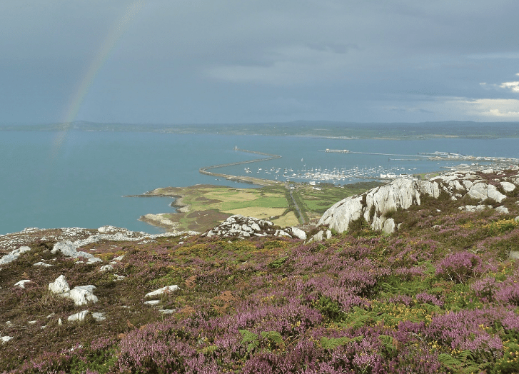
Holyhead is not actually on the main island of Anglesey but is on Holy Island, connected by two road links. It’s a busy ferry port with regular sailings to and from Ireland. The harbour’s impressive breakwater – the longest in the UK at over two kilometres – was completed in 1873 after 28 years of labour.
From the Boathouse Hotel I followed the tarmac no through road, signed with both the Anglesey Coastal Path waymark (featuring a hovering tern) and the Wales Coast Path shell waymark – you can’t go wrong! Beyond some derelict buildings, including the former Soldier’s Point Hotel (a white castellated Victorian mansion earmarked for renovation as part of the waterfront redevelopment plans), the path leads down to a beach of white pebbles and an attractive stretch of coastline, known locally as the Rocky Coast. This area is part of the Holyhead Breakwater Country Park – hence the information boards and charming little mosaics and carved wooden benches.
For no other reason than just to check it out, I turned off the Coast Path towards the car park and information centre, situated in the site of an old quarry which supplied stone for the breakwater. It proved a very worthwhile detour. Much work has obviously gone into transforming the site, with an attractive little lake, smart new café, a North Wales Wildlife Trust centre and outdoor exhibits. I was particularly impressed by the displays in the Brick Shed Gallery.
Back on the Coast Path, I was soon heading up a stone-pitched path leading past an old magazine building, once used to store explosives for the quarry. It was good to gain some height and look back down on the impressive breakwater. Before long I dropped back down towards North Stack. The old foghorn station here (currently up for sale) has been an artist’s studio for almost 25 years – quite some location, perched atop the sheer cliffs. I sat on the grass among a cloud of seapinks looking out over the sparkling blue of the sea below me, a clear blue, sunny sky overhead. As if the superb views and cliff scenery weren’t enough, I spotted half a dozen seals bobbing playfully about in the water and could happily have whiled away the afternoon watching them.
But onwards and upwards…. and so to the top of Holyhead Mountain, Anglesey’s highest point; only 220m/722ft, but an excellent viewpoint (and the site of an Iron Age hill fort). Thence across the rocky, heather-clad terrain to an old lookout on the cliff-top and an impressive view of South Stack and its lighthouse below. The imposing cliffs are famous for the thousands of breeding seabirds that perch wing-by-wing on the narrow ledges. Having descended and partly reascended the 400 steps that lead down to the footbridge, I stopped to enjoy the spectacle, pleased to spot a couple of puffins amid the multitude of guillemots.
Thereafter, with the day’s (distracting) highlights behind me, I made quicker progress along the Coast Path round headlands and sandy bays towards Trearddur. An RAF Search and Rescue helicopter out on a training exercise from nearby Valley provided one final distraction; whether piloted by a certain royal (he was still based there at the time) I knew not. Trearddur was surprisingly quiet – no doubt many buildings are holiday homes. There was time to linger and watch the sunset from the fine sandy beach before catching the bus back to Holyhead. A memorable walk and well worth coming all this way.
ROUTE DESCRIPTION
- [1] Follow Isle of Anglesey Coastal Path/ Wales Coast Path waymarks, initially along a tarmac lane, then path. Short detour to Holyhead Breakwater Country Park info centre, etc. At fork bear R down to North Stack.
- [2] Continue S along Coast Path, detour L to climb to summit of Holyhead Mountain.
- [3] Rejoin Coast Path and continue to South Stack.
- [4] Pass Ellin’s Tower (RSPB) and continue along cliff-top to car park and road. Note hut circles (info board) on opposite side. Follow lane to junction, then along path parallel to road, rejoining cliff-top path thereafter. Continue along Coast Path via Porth Dafarch to Trearddur. Bus back to Holyhead. St Cybi’s Church (official start/finish point of the Anglesey Coastal Path) is worth a look on walk back from town centre bus stop to car park.

There’s more to Holyhead than meets the eye, discovers Fiona Barltrop
Approaching Holyhead along the fast dual carriageway that whisks you across Anglesey from the mainland, you might well wonder – if it’s your first visit – why you’ve come all this way. Visible from afar, the tall chimney of the former aluminium smelting works is the town’s most obvious landmark, but changes are afoot for the site with a biomass plant and eco park in the planning stage. And there’s a regeneration scheme ongoing in Holyhead itself, which is encouraging.
Holyhead is not actually on the main island of Anglesey but is on Holy Island, connected by two road links. It’s a busy ferry port with regular sailings to and from Ireland. The harbour’s impressive breakwater – the longest in the UK at over two kilometres – was completed in 1873 after 28 years of labour.
From the Boathouse Hotel I followed the tarmac no through road, signed with both the Anglesey Coastal Path waymark (featuring a hovering tern) and the Wales Coast Path shell waymark – you can’t go wrong! Beyond some derelict buildings, including the former Soldier’s Point Hotel (a white castellated Victorian mansion earmarked for renovation as part of the waterfront redevelopment plans), the path leads down to a beach of white pebbles and an attractive stretch of coastline, known locally as the Rocky Coast. This area is part of the Holyhead Breakwater Country Park – hence the information boards and charming little mosaics and carved wooden benches.
For no other reason than just to check it out, I turned off the Coast Path towards the car park and information centre, situated in the site of an old quarry which supplied stone for the breakwater. It proved a very worthwhile detour. Much work has obviously gone into transforming the site, with an attractive little lake, smart new café, a North Wales Wildlife Trust centre and outdoor exhibits. I was particularly impressed by the displays in the Brick Shed Gallery.
Back on the Coast Path, I was soon heading up a stone-pitched path leading past an old magazine building, once used to store explosives for the quarry. It was good to gain some height and look back down on the impressive breakwater. Before long I dropped back down towards North Stack. The old foghorn station here (currently up for sale) has been an artist’s studio for almost 25 years – quite some location, perched atop the sheer cliffs. I sat on the grass among a cloud of seapinks looking out over the sparkling blue of the sea below me, a clear blue, sunny sky overhead. As if the superb views and cliff scenery weren’t enough, I spotted half a dozen seals bobbing playfully about in the water and could happily have whiled away the afternoon watching them.
But onwards and upwards…. and so to the top of Holyhead Mountain, Anglesey’s highest point; only 220m/722ft, but an excellent viewpoint (and the site of an Iron Age hill fort). Thence across the rocky, heather-clad terrain to an old lookout on the cliff-top and an impressive view of South Stack and its lighthouse below. The imposing cliffs are famous for the thousands of breeding seabirds that perch wing-by-wing on the narrow ledges. Having descended and partly reascended the 400 steps that lead down to the footbridge, I stopped to enjoy the spectacle, pleased to spot a couple of puffins amid the multitude of guillemots.
Thereafter, with the day’s (distracting) highlights behind me, I made quicker progress along the Coast Path round headlands and sandy bays towards Trearddur. An RAF Search and Rescue helicopter out on a training exercise from nearby Valley provided one final distraction; whether piloted by a certain royal (he was still based there at the time) I knew not. Trearddur was surprisingly quiet – no doubt many buildings are holiday homes. There was time to linger and watch the sunset from the fine sandy beach before catching the bus back to Holyhead. A memorable walk and well worth coming all this way.
ROUTE DESCRIPTION
- [1] Follow Isle of Anglesey Coastal Path/ Wales Coast Path waymarks, initially along a tarmac lane, then path. Short detour to Holyhead Breakwater Country Park info centre, etc. At fork bear R down to North Stack.
- [2] Continue S along Coast Path, detour L to climb to summit of Holyhead Mountain.
- [3] Rejoin Coast Path and continue to South Stack.
- [4] Pass Ellin’s Tower (RSPB) and continue along cliff-top to car park and road. Note hut circles (info board) on opposite side. Follow lane to junction, then along path parallel to road, rejoining cliff-top path thereafter. Continue along Coast Path via Porth Dafarch to Trearddur. Bus back to Holyhead. St Cybi’s Church (official start/finish point of the Anglesey Coastal Path) is worth a look on walk back from town centre bus stop to car park.


