

Secluded valleys lead to superlative sea views on this rolling Exmoor ride, writes Paul Beasley
The day began under a veil of haze, in a car park on the Devon-Somerset border, overlooking a valley made famous by RD Blackmore’s novel Lorna Doone. But this wasn’t to be a paddle upstream into the eddy of pseudo-history, but downstream, going with the flow before a short, sharp cut to the coast. So rather than south into Doone-land I headed west, around the kink of Ashton Cleave, then tracked along the East Lyn River, passing between gorse and pasture on the northern slope of the valley as it widened, below me, like a gorged snake.
Three kilometres, four path-blocking ponies, seven scattered sheep and countless chirping birds later, a hard dogleg swung me across a small field and down to earth by the village of Brendon. From here, the path continued beyond a bridge, following the river into a series of woods. By now the sun’s rays were strengthening, burning through the mist like an iron through steam, lending translucence to the leaves. Having rushed through channels, roared down drops, then slackened off in the shallows, the East Lyn gathered itself again and, finally, sped to its comingling at Watersmeet.
I surveyed the scene in layers: blue sky; the brightest leaves exploding from the hillside; grey-black rocks; brown-green water combed with white; and, sandwiched between, blissed-out visitors drifting by. Sorely tempted by the scones on offer at Watersmeet House – oh for a dollop of jam and a smear of clotted cream – I nevertheless didn’t tarry, not wanting to ballast my belly-pack before hauling it uphill. Instead, I slathered on more sunscreen and leant in to the lean of the land. Alone again, I climbed up the shaded valley-side, zig-zagging through stands of trees, their crinkled branches downed with tiny buds.
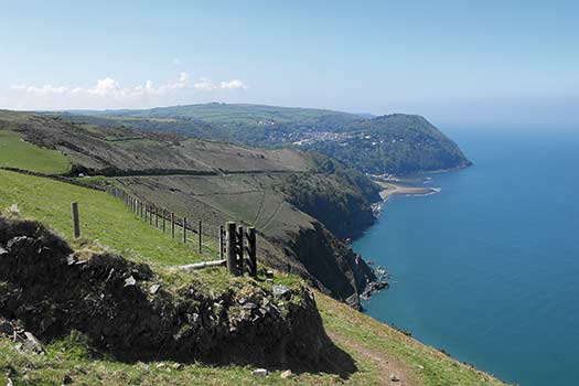
Out in the open, a brisk skirting of South Hill Common led me to the A39, just a stone’s throw from Countisbury, at which point I barely managed to resist a pint at the Blue Ball Inn. Good call, as it turned out: the South West Coast Path around Butter Hill is not for the pie-eyed. Along this tilting plane of greens sandwiched between two blues I suddenly felt all slipshod, acutely aware of the usually subconscious mechanics of motion. Stutteringly, I made what felt like landfall at Great Red, and continued on to the lighthouse at Foreland Point. Here, I rested, my back braced against the slope of the scenery, my brain suggesting that, on a day like this, Britain is a match for meanders beside the Med. Up and on again, I returned to the coast path, heading east – the rhododendrons to my left screening me from the surf below, its sounds swirling in my ears.
This rolling coastal ride was paused just three times: firstly, by a man, ultra-lightweight in form, boiled down to the bones, ghosting along; then three fortysomething men, ruddy, perhaps, with the good cheer of a stag party, measuring out the miles to a second marriage; then, finally, a older couple – the man ample and cheery, the woman sprung like a thrush on a wet lawn.
“Have you come straight from Porlock?” I asked.
“It’s not straight!” the white-plumed lady shot back.
“As the crow flies.” I proferred.
“We’re not crows!” she insisted.
“It’s a bad design, this – all these wiggly bits”, I quipped, adding: “It should be modernised!”
“Well then… we should call the bulldozers in.” she scoffed.
“What a good idea”, I replied. Not sure if my jack of irony was being trumped by a queen of sarcasm, I folded. “Bye!”
Not long after, the path cranked inland, leading to a crossroads of sorts. Taking route one, I levered myself onwards, as stiff-legged as a toy robot, and was relieved to reach the County Gate Visitor Centre, thereby clasping shut the looping route I’d opened some five hours or so earlier.
Things perked up further when my question about food was met with the following words: “There’s a pasty.” This could be the start of something beautiful, I thought – but, little over five minutes later, it was all over. Heavier, yet happier, and with some brilliantly lit scenes secreted in my memory banks, I stole away, freighted with fat, protein and path-plunder.
ROUTE DESCRIPTION
- Take the path that starts in the western corner of the car park (not the one marked ‘Circular Route’) and follow the steep contours of the valley down to the village of Brendon. The path deposits you outside Hall Farm.
- Follow the road into the village. The path continues to the left of the road about 100m past the bridge. Go through the gate for Countisbury Mill, continue on gravel track and pass through second gate – Watersmeet is about 2 miles away along a woodland path that generally hugs the riverbank.
- On reaching Watersmeet, double back 100m past the National Trust property and take path to left signposted ‘Countisbury’. Climb the switchbacks through woodland, sticking to clearest, widest path. At top of slope, continue along grassy path across grassy ridge between trees, then take left-hand fork and continue to A39. Cross road and continue up steps on opposite side, following wall N to ‘Coastal Path’ sign.
- Continue N/NE on Coastal Path, ignoring track over Butter Hill and two other paths to the right, following tightly packed contours on to the lighthouse at Foreland Point (taking the second or third right-turn reduces the distance by approximately 500m, but you’ll miss the lighthouse). If you come to a sign for the lighthouse that points E, ignore it!
- After lighthouse, path becomes tarmac lane as you head S to rejoin the South West Coastal Path. At top of steep climb, leave lane (it swings hard right) and continue on track ahead, into the grounds of Rodney Cottage, then immediately take path to right of track, up steps. Continue for approximately 4km, ignoring path to R signed ‘County Gate 2¼ miles’. Path turns S and passes ‘The Combe’ (a house); shortly afterwards, just before gateposts, path continues to left of track. Follow sign to ‘County Gate’, then after gate either choose the nature trail (orange arrowhead) or shorter, steeper path back to the start.

Secluded valleys lead to superlative sea views on this rolling Exmoor ride, writes Paul Beasley
The day began under a veil of haze, in a car park on the Devon-Somerset border, overlooking a valley made famous by RD Blackmore’s novel Lorna Doone. But this wasn’t to be a paddle upstream into the eddy of pseudo-history, but downstream, going with the flow before a short, sharp cut to the coast. So rather than south into Doone-land I headed west, around the kink of Ashton Cleave, then tracked along the East Lyn River, passing between gorse and pasture on the northern slope of the valley as it widened, below me, like a gorged snake.
Three kilometres, four path-blocking ponies, seven scattered sheep and countless chirping birds later, a hard dogleg swung me across a small field and down to earth by the village of Brendon. From here, the path continued beyond a bridge, following the river into a series of woods. By now the sun’s rays were strengthening, burning through the mist like an iron through steam, lending translucence to the leaves. Having rushed through channels, roared down drops, then slackened off in the shallows, the East Lyn gathered itself again and, finally, sped to its comingling at Watersmeet.
I surveyed the scene in layers: blue sky; the brightest leaves exploding from the hillside; grey-black rocks; brown-green water combed with white; and, sandwiched between, blissed-out visitors drifting by. Sorely tempted by the scones on offer at Watersmeet House – oh for a dollop of jam and a smear of clotted cream – I nevertheless didn’t tarry, not wanting to ballast my belly-pack before hauling it uphill. Instead, I slathered on more sunscreen and leant in to the lean of the land. Alone again, I climbed up the shaded valley-side, zig-zagging through stands of trees, their crinkled branches downed with tiny buds.
Out in the open, a brisk skirting of South Hill Common led me to the A39, just a stone’s throw from Countisbury, at which point I barely managed to resist a pint at the Blue Ball Inn. Good call, as it turned out: the South West Coast Path around Butter Hill is not for the pie-eyed. Along this tilting plane of greens sandwiched between two blues I suddenly felt all slipshod, acutely aware of the usually subconscious mechanics of motion. Stutteringly, I made what felt like landfall at Great Red, and continued on to the lighthouse at Foreland Point. Here, I rested, my back braced against the slope of the scenery, my brain suggesting that, on a day like this, Britain is a match for meanders beside the Med. Up and on again, I returned to the coast path, heading east – the rhododendrons to my left screening me from the surf below, its sounds swirling in my ears.
This rolling coastal ride was paused just three times: firstly, by a man, ultra-lightweight in form, boiled down to the bones, ghosting along; then three fortysomething men, ruddy, perhaps, with the good cheer of a stag party, measuring out the miles to a second marriage; then, finally, a older couple – the man ample and cheery, the woman sprung like a thrush on a wet lawn.
“Have you come straight from Porlock?” I asked.
“It’s not straight!” the white-plumed lady shot back.
“As the crow flies.” I proferred.
“We’re not crows!” she insisted.
“It’s a bad design, this – all these wiggly bits”, I quipped, adding: “It should be modernised!”
“Well then… we should call the bulldozers in.” she scoffed.
“What a good idea”, I replied. Not sure if my jack of irony was being trumped by a queen of sarcasm, I folded. “Bye!”
Not long after, the path cranked inland, leading to a crossroads of sorts. Taking route one, I levered myself onwards, as stiff-legged as a toy robot, and was relieved to reach the County Gate Visitor Centre, thereby clasping shut the looping route I’d opened some five hours or so earlier.
Things perked up further when my question about food was met with the following words: “There’s a pasty.” This could be the start of something beautiful, I thought – but, little over five minutes later, it was all over. Heavier, yet happier, and with some brilliantly lit scenes secreted in my memory banks, I stole away, freighted with fat, protein and path-plunder.
ROUTE DESCRIPTION
- Take the path that starts in the western corner of the car park (not the one marked ‘Circular Route’) and follow the steep contours of the valley down to the village of Brendon. The path deposits you outside Hall Farm.
- Follow the road into the village. The path continues to the left of the road about 100m past the bridge. Go through the gate for Countisbury Mill, continue on gravel track and pass through second gate – Watersmeet is about 2 miles away along a woodland path that generally hugs the riverbank.
- On reaching Watersmeet, double back 100m past the National Trust property and take path to left signposted ‘Countisbury’. Climb the switchbacks through woodland, sticking to clearest, widest path. At top of slope, continue along grassy path across grassy ridge between trees, then take left-hand fork and continue to A39. Cross road and continue up steps on opposite side, following wall N to ‘Coastal Path’ sign.
- Continue N/NE on Coastal Path, ignoring track over Butter Hill and two other paths to the right, following tightly packed contours on to the lighthouse at Foreland Point (taking the second or third right-turn reduces the distance by approximately 500m, but you’ll miss the lighthouse). If you come to a sign for the lighthouse that points E, ignore it!
- After lighthouse, path becomes tarmac lane as you head S to rejoin the South West Coastal Path. At top of steep climb, leave lane (it swings hard right) and continue on track ahead, into the grounds of Rodney Cottage, then immediately take path to right of track, up steps. Continue for approximately 4km, ignoring path to R signed ‘County Gate 2¼ miles’. Path turns S and passes ‘The Combe’ (a house); shortly afterwards, just before gateposts, path continues to left of track. Follow sign to ‘County Gate’, then after gate either choose the nature trail (orange arrowhead) or shorter, steeper path back to the start.


