
Roger Butler spends a serene day in the Shropshire Hills
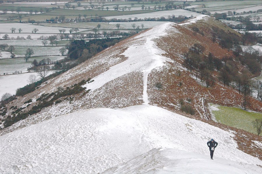
I backtracked along the wide tussocky path, dropped down to cross the B4371 and climbed onto Hope Bowdler Hill. If Ragleth’s long summit resembled a humpback whale, Hope Bowdler was a series of leatherback turtles, gently domed and dipping slowly eastwards towards the wooded waves of Wenlock Edge. Up here the snow was a few inches deep and, following the recent tracks of a hare, I slowed down to enjoy the wide horizons and dramatic cloud formations. I stopped for a bite to eat by the rocky outcrop known as the Battle Stones, right on top of Willstone Hill. A series of shy twisting valleys led down to the Shropshire Plain, punctuated in the distance by the unmistakeable shape of The Wrekin.
My next target was Caer Caradoc, which stood proudly aloof as sudden bright sunshine seemed to exaggerate its height. A surprisingly icy descent down north facing slopes led to a grassy bridleway where a stoat hurtled into last year’s bracken. Well worn paths then took me to the summit, which greeted me with a chill wind and heavy snowflakes. Centuries ago the residents in the old hill fort would probably have closed their shutters on a day like this. On the sheltered lower slopes the bare branches of oak and ash trees were dusted in snow which had created a gallery of eye-catching patterns and textures.
I now looked north towards the prominent little peak known as The Lawley. It’s so perfectly pointed a child might have made it at nursery school. Without hesitation, deviation or repetition, the path took me swiftly to the top, marked by a tall weathervane capped with a black metal raven. Then it was straight down the other side, along a humpy ridge that made me want to flap my wings and fly. When I met the lane I turned immediately south along paths that closely hug the lower slopes of The Lawley and Caer Caradoc. As dusk arrived I watched starlings gather below the Long Mynd and passed a couple of old timbered farmhouses that must surely have been haunted.
ROUTE DESCRIPTION
- From E side of A49 follow Jack Mytton Way (signed) SE past houses into steep woodland. On reaching open land climb Ragleth Hill and continue to SW summit.
- Return same way but turn SE at end to reach narrow lane. Turn L then after 150m L on path through woods to B4371. Cross road, take track opposite, fork R after 90m and climb to rocks marked on map as Gaer Stone. Continue NE to Hope Bowdler Hill.
- Descend NW to broad valley below Caer Caradoc, climb slopes to summit.
- Descend NNE to lane at Comley, at Comley Farm turn R on bridleway. Leave bridleway, go through gate on path up The Lawley. Continue over summit and descend directly to lane. Take bridleway running SW along foot of W slopes. Similar route continues along foot of Caer Caradoc.
- At S end descend to stream and take path heading SW to Church Stretton.

Roger Butler spends a serene day in the Shropshire Hills
I backtracked along the wide tussocky path, dropped down to cross the B4371 and climbed onto Hope Bowdler Hill. If Ragleth’s long summit resembled a humpback whale, Hope Bowdler was a series of leatherback turtles, gently domed and dipping slowly eastwards towards the wooded waves of Wenlock Edge. Up here the snow was a few inches deep and, following the recent tracks of a hare, I slowed down to enjoy the wide horizons and dramatic cloud formations. I stopped for a bite to eat by the rocky outcrop known as the Battle Stones, right on top of Willstone Hill. A series of shy twisting valleys led down to the Shropshire Plain, punctuated in the distance by the unmistakeable shape of The Wrekin.
My next target was Caer Caradoc, which stood proudly aloof as sudden bright sunshine seemed to exaggerate its height. A surprisingly icy descent down north facing slopes led to a grassy bridleway where a stoat hurtled into last year’s bracken. Well worn paths then took me to the summit, which greeted me with a chill wind and heavy snowflakes. Centuries ago the residents in the old hill fort would probably have closed their shutters on a day like this. On the sheltered lower slopes the bare branches of oak and ash trees were dusted in snow which had created a gallery of eye-catching patterns and textures.
I now looked north towards the prominent little peak known as The Lawley. It’s so perfectly pointed a child might have made it at nursery school. Without hesitation, deviation or repetition, the path took me swiftly to the top, marked by a tall weathervane capped with a black metal raven. Then it was straight down the other side, along a humpy ridge that made me want to flap my wings and fly. When I met the lane I turned immediately south along paths that closely hug the lower slopes of The Lawley and Caer Caradoc. As dusk arrived I watched starlings gather below the Long Mynd and passed a couple of old timbered farmhouses that must surely have been haunted.
ROUTE DESCRIPTION
- From E side of A49 follow Jack Mytton Way (signed) SE past houses into steep woodland. On reaching open land climb Ragleth Hill and continue to SW summit.
- Return same way but turn SE at end to reach narrow lane. Turn L then after 150m L on path through woods to B4371. Cross road, take track opposite, fork R after 90m and climb to rocks marked on map as Gaer Stone. Continue NE to Hope Bowdler Hill.
- Descend NW to broad valley below Caer Caradoc, climb slopes to summit.
- Descend NNE to lane at Comley, at Comley Farm turn R on bridleway. Leave bridleway, go through gate on path up The Lawley. Continue over summit and descend directly to lane. Take bridleway running SW along foot of W slopes. Similar route continues along foot of Caer Caradoc.
- At S end descend to stream and take path heading SW to Church Stretton.


