

Keith Fergus explores Galloway’s highest mountain and finds some of the most beautiful scenery in Scotland
The Merrick is Galloway’s highest mountain and also the highest point in Scotland south of Arran’s Goat Fell. However, anyone thinking of The Merrick simply in these terms is missing the point – a walk over this wonderful mountain, and its surrounding landscape, grants some of Scotland’s finest scenery, one dotted with craggy peaks, stunning lochs and wild, lonely glens.
My day began under a gorgeous blue sky, only broken by two red kites who glided gracefully above the calm waters of Loch Trool. Here I paid a quick visit to Bruce’s Stone, commemorating the Battle of Glen Trool, which took place here in 1307 – Robert the Bruce led his loyal Scottish army to a famous victory over English forces.
I left the stone and road behind to enter a lonelier landscape beneath the rocky Buchan Hill and walked alongside the Gairland Burn. I usually prefer to gain height quickly but this route, which rises gradually, makes its way by a series of beautiful lochs, all of which would not look out of place within a more renowned Highland glen. It is, to my mind, the finest way to gain The Merrick’s 843-metre summit.
It was not long before I passed the cold, glassy waters of Loch Valley and then Loch Neldricken. Any signs of human habitation were now non-existent. I was bounded by the craggy slopes of Craignaw and the Rig of Loch Enoch and the two red kites seen earlier were now joined by a pair of ravens who seemed determined to defend their territory.
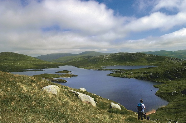
Once past little Loch Arron I hiked above Loch Enoch, the most scenic of all these lochs. I sat awhile and gazed down onto its sandy shores and little island, itself containing its own lochan. I also scanned the map and became intrigued by the language of the Galloway landscape: Mullwharchar, The Wolf
ROUTE DESCRIPTION
- From the car park, follow the road east across a bridge then turn L over a stile for Gairland Burn and Loch Valley. Path climbs gradually and beyond a couple of gates and continues NE alongside the Gairland Burn to Loch Valley.
- Continue along western shore, the path now a little indistinct, then pass Loch Neldricken. After a wall at Murder Hole, keep N past Ewe Rig and Loch Arron.
- The path eventually peters out. Head NW away from Loch Enoch up the steep, grassy Redstone Rig to gain the summit of The Merrick.
- Descend a good path SW, contouring Neive of the Spit. It then follows the line of a wall with a short ascent onto Benyellary.
- Continue SW then SSE, dropping steeply into a forest and down to a track. Turn right over a bridge then left. The path passes Culsharg Bothy then runs alongside the Buchan Burn back to Loch Trool.

Keith Fergus explores Galloway’s highest mountain and finds some of the most beautiful scenery in Scotland
The Merrick is Galloway’s highest mountain and also the highest point in Scotland south of Arran’s Goat Fell. However, anyone thinking of The Merrick simply in these terms is missing the point – a walk over this wonderful mountain, and its surrounding landscape, grants some of Scotland’s finest scenery, one dotted with craggy peaks, stunning lochs and wild, lonely glens.
My day began under a gorgeous blue sky, only broken by two red kites who glided gracefully above the calm waters of Loch Trool. Here I paid a quick visit to Bruce’s Stone, commemorating the Battle of Glen Trool, which took place here in 1307 – Robert the Bruce led his loyal Scottish army to a famous victory over English forces.
I left the stone and road behind to enter a lonelier landscape beneath the rocky Buchan Hill and walked alongside the Gairland Burn. I usually prefer to gain height quickly but this route, which rises gradually, makes its way by a series of beautiful lochs, all of which would not look out of place within a more renowned Highland glen. It is, to my mind, the finest way to gain The Merrick’s 843-metre summit.
It was not long before I passed the cold, glassy waters of Loch Valley and then Loch Neldricken. Any signs of human habitation were now non-existent. I was bounded by the craggy slopes of Craignaw and the Rig of Loch Enoch and the two red kites seen earlier were now joined by a pair of ravens who seemed determined to defend their territory.
Once past little Loch Arron I hiked above Loch Enoch, the most scenic of all these lochs. I sat awhile and gazed down onto its sandy shores and little island, itself containing its own lochan. I also scanned the map and became intrigued by the language of the Galloway landscape: Mullwharchar, The Wolf
ROUTE DESCRIPTION
- From the car park, follow the road east across a bridge then turn L over a stile for Gairland Burn and Loch Valley. Path climbs gradually and beyond a couple of gates and continues NE alongside the Gairland Burn to Loch Valley.
- Continue along western shore, the path now a little indistinct, then pass Loch Neldricken. After a wall at Murder Hole, keep N past Ewe Rig and Loch Arron.
- The path eventually peters out. Head NW away from Loch Enoch up the steep, grassy Redstone Rig to gain the summit of The Merrick.
- Descend a good path SW, contouring Neive of the Spit. It then follows the line of a wall with a short ascent onto Benyellary.
- Continue SW then SSE, dropping steeply into a forest and down to a track. Turn right over a bridge then left. The path passes Culsharg Bothy then runs alongside the Buchan Burn back to Loch Trool.


