
Ronald Turnbull enoys high adventure on a low level walk
KINLOCHEWE IS ONE of Scotland’s finest mountain centres, and never mind its lack of streetlights, shopping opportunities, and interactive visitor experiences. What is, after all, the essential of a mountain centre? Mountains. Slioch, Liathach, Beinn Eighe; with the Great Wilderness a day’s wild backpacking away, and the so-tempting if slightly smaller hills south of Loch Torridon.
But when clouds are low over all these high-grade hills: what to do, at Kinlochewe? There’s only so much time you can spend browsing socks and midge nets in the wellstocked village store. After that, it’s the low level route around the Heights of Kinlochewe.
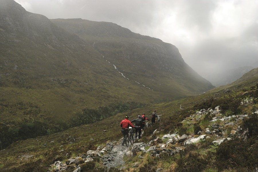
We crossed the noisy brown river and headed out of the village by the old burial ground. As we emerged to the pebbled foreshore of Loch Maree, the base of Beinn Eighe streamed waterfalls on the other side. Gleann Bianasdail is beautiful with waterfalls, crags (sandstone on the left, quartzite on the right), pines and birch. The crossing of Allt Coire na Sleaghaich is marked on the Explorer map as having FB, which should stand for footbridge. There is no bridge, and the stream was a series of waterfalls, and a detour upstream to find a midstream island. Even on the island we were sprayed, and scrambling through moving water.
The valley head gave a view of Lochan Fada. To get to it, we had to cross Allt Leacach. This was wider, but less steeply waterfally, than the previous stream. The path now turned downhill to reach the outflow of Lochan Fada.
This crossing is marked ‘stepping stones’. Any stepping stones under there were more than knee-deep, but as the water is effectively the edge of the loch, it was moving fairly slow. The relentless rainfall made a hissing sound on the loch surface alongside.
Authorities state: for the crossing, socks off then boots back on again. But with another stream ahead, this would mean boots off four times over, in the rain on each occasion. And for no great gain, as socks would be sucking water from soaked boots twice over. Better to stride straight through, and after crossing number two to take off and squeeze the socks. Ten minutes later, when socks have re-absorbed water from wet boots, to stop and squeeze again.
Between the two streams the path wandered along pebbly beaches at the eastern end of Lochan Fada. The long grey water faded into grey cloud, and the steely shapes of the Great Wilderness were painted in washed out watercolour.
A much easier path runs southeast, down into Gleann na Muice. It becomes wide and smooth through a fenced regeneration area where the trees, planted in 2004, are now starting to be seen above the tussocks. The path becomes a rough track, then a smooth one. Beyond the brown river, waterfalls tumble down the slopes of Srath Chrombuill.
Waterfalls are even more enjoyable when you don’t have to wade across them
ROUTE DESCRIPTION
- From Kinlochewe, follow A832 over river to lane on left. Cross Kinlochewe River to fork (car park in right fork lane) and turn L.
- At track end pass L of cemetery to path along slope foot, through deer fence gate, to Loch Maree shore.
- Cross bridge over Abhainn an Fhasaigh and take path up Gleann Bianasdail. Ignore left fork towards Slioch.
- After 5km, crossing of sidestream (NH027673) dangerous when in full spate. Path rises to avoid river gorge, to cross another stream (NH036693) to outflow of Lochan Fada.
- Cross stepping stones, covered when river full. Faint path to E end of loch.
- Cross stream and turn R to find good path down Gleann na Muice.
- Path becomes track, crossing Abhainn Gleann na Muice.
- At Heights of Kinlochewe a smooth track leads down valley to Incheril.

Ronald Turnbull enoys high adventure on a low level walk
KINLOCHEWE IS ONE of Scotland’s finest mountain centres, and never mind its lack of streetlights, shopping opportunities, and interactive visitor experiences. What is, after all, the essential of a mountain centre? Mountains. Slioch, Liathach, Beinn Eighe; with the Great Wilderness a day’s wild backpacking away, and the so-tempting if slightly smaller hills south of Loch Torridon.
But when clouds are low over all these high-grade hills: what to do, at Kinlochewe? There’s only so much time you can spend browsing socks and midge nets in the wellstocked village store. After that, it’s the low level route around the Heights of Kinlochewe.
We crossed the noisy brown river and headed out of the village by the old burial ground. As we emerged to the pebbled foreshore of Loch Maree, the base of Beinn Eighe streamed waterfalls on the other side. Gleann Bianasdail is beautiful with waterfalls, crags (sandstone on the left, quartzite on the right), pines and birch. The crossing of Allt Coire na Sleaghaich is marked on the Explorer map as having FB, which should stand for footbridge. There is no bridge, and the stream was a series of waterfalls, and a detour upstream to find a midstream island. Even on the island we were sprayed, and scrambling through moving water.
The valley head gave a view of Lochan Fada. To get to it, we had to cross Allt Leacach. This was wider, but less steeply waterfally, than the previous stream. The path now turned downhill to reach the outflow of Lochan Fada.
This crossing is marked ‘stepping stones’. Any stepping stones under there were more than knee-deep, but as the water is effectively the edge of the loch, it was moving fairly slow. The relentless rainfall made a hissing sound on the loch surface alongside.
Authorities state: for the crossing, socks off then boots back on again. But with another stream ahead, this would mean boots off four times over, in the rain on each occasion. And for no great gain, as socks would be sucking water from soaked boots twice over. Better to stride straight through, and after crossing number two to take off and squeeze the socks. Ten minutes later, when socks have re-absorbed water from wet boots, to stop and squeeze again.
Between the two streams the path wandered along pebbly beaches at the eastern end of Lochan Fada. The long grey water faded into grey cloud, and the steely shapes of the Great Wilderness were painted in washed out watercolour.
A much easier path runs southeast, down into Gleann na Muice. It becomes wide and smooth through a fenced regeneration area where the trees, planted in 2004, are now starting to be seen above the tussocks. The path becomes a rough track, then a smooth one. Beyond the brown river, waterfalls tumble down the slopes of Srath Chrombuill.
Waterfalls are even more enjoyable when you don’t have to wade across them
ROUTE DESCRIPTION
- From Kinlochewe, follow A832 over river to lane on left. Cross Kinlochewe River to fork (car park in right fork lane) and turn L.
- At track end pass L of cemetery to path along slope foot, through deer fence gate, to Loch Maree shore.
- Cross bridge over Abhainn an Fhasaigh and take path up Gleann Bianasdail. Ignore left fork towards Slioch.
- After 5km, crossing of sidestream (NH027673) dangerous when in full spate. Path rises to avoid river gorge, to cross another stream (NH036693) to outflow of Lochan Fada.
- Cross stepping stones, covered when river full. Faint path to E end of loch.
- Cross stream and turn R to find good path down Gleann na Muice.
- Path becomes track, crossing Abhainn Gleann na Muice.
- At Heights of Kinlochewe a smooth track leads down valley to Incheril.


