
Vivienne Crow enjoys one of the high-level options as Wainwright’s Coast to Coast route crosses the fells dividing Grasmere from Patterdale.
Soon to become one of England and Wales’s National Trails, Wainwright’s Coast to Coast route passes through three spectacular National Parks on its 306km journey across northern England. Each park has a character of its own, but the most rugged and most mountainous stretches are those through the Lake District. After climbing to the perfect teardrop of Grisedale Tarn, the section from Grasmere to Patterdale offers three contrasting options: down through the glacial trough of Grisedale; up and over Helvellyn, using Striding Edge in its descent; or over St Sunday Crag. The hike described here takes the latter route. At Deepdale Hause, it joins a high ridge, broad enough to feel safe in all but the trickiest conditions but narrow enough to give an airy sense of spaciousness. From the 841m summit, views across to the Helvellyn group and of Ullswater straight ahead then dominate the descent.
Wainwright’s Coast to Coast (Grasmere – Patterdale): route description
START: Sam Read bookshop, Grasmere; GR NY336076 | FINISH: White Lion Inn, Patterdale; GR NY397158 | MAPS: OS Explorer OL5 (1:25k), OS Landranger 90 (1:50k), Harvey 1:25,000 Superwalker Lake District East | DISTANCE: 12.2km / 7.6 miles | ASCENT: 832m / 2,730ft | DURATION: 5 hours
1. NY336076: From the Sam Read bookshop, cross the main road through Grasmere and follow Easedale Road northwest. After 650m, take the narrow lane on the right. Turn right at a T-junction, crossing Low Mill Bridge over the River Rothay. On reaching the A591, cross over to take the rough track opposite. Beyond the cottages, you climb beside Tongue Gill.
2. NY339098: About 700m beyond the A591, pass through a gate to reach the point where Little Tongue Gill and Tongue Gill meet. Cross the bridge over Little Tongue Gill and bear left. After fording a beck, the path follows the crest of a spur known as Little Tongue – on a broad, grassy line through the bracken. It then swings right to pass along the top of a line of crags at Hause Riggs. You’re soon able to look across the waterfall on Tongue Gill to Fairfield on the other side.
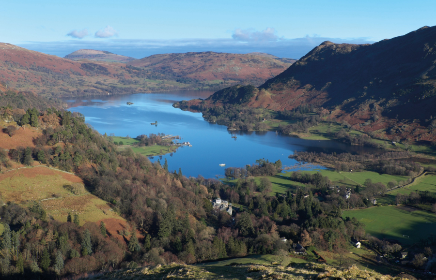
3. NY348112: At a path junction, keep left. Continue uphill, the gradient steepening as you near Grisedale Hause. Once through the gap in the wall at the top of the climb, ignore the path climbing beside the wall. Keep straight ahead, descending gently as you aim for the eastern end of Grisedale Tarn, a dark body of water cradled by the Helvellyn range to the north, the Fairfield group to the south and with Seat Sandal looming over it to the west.
Looking down on Grisedale Tarn from Deepdale Hause.
Credit: Vivienne Crow
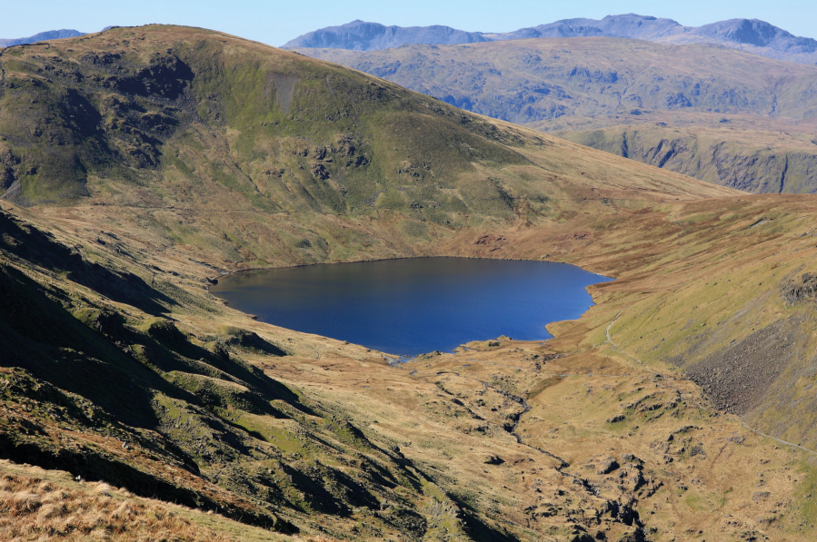
4. NY349117: The path forks on the way down. Bear right here, later joining a path coming up from the tarn. On reaching a cairn, keep to the clear path straight ahead. This eases its way across Cofa Pike’s western slopes, providing an opportunity to enjoy the spectacular surroundings. Immediately below is beautiful Grisedale, but on the other side of the valley are the coves, crags and gullies of Dollywaggon Pike, Nethermost Pike and Helvellyn. The furthest ridge to the north is Striding Edge. At the next fork, don’t be tempted by the fine-looking path straight ahead; instead, head up to the right on a steep, badly eroded trail. This quickly climbs to the ridge at Deepdale Hause.

The crags, gullies and coves of Dollywaggon Pike seen from St Sunday Crag.
Credit: Vivienne Crow
5. NY359124: Turn left, enjoying a fresh outlook to the east. Layer upon layer of grassy ridges march off into the distance. Closer in, the complex group of dark crags over to the right – on the other side of lonely Deepdale – belongs to Fairfield. It’s a great bit of ridge, but sadly short; it’s not long before the main path leads up to the highest point on St Sunday Crag (841m/2,759ft).
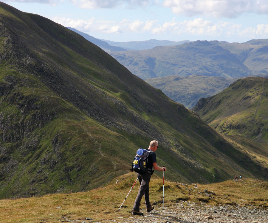
A walker descends to Deepdale Hause from St Sunday Crag.
Credit: Vivienne Crow
6. NY369134: Head north across the rock-strewn summit plateau to pick up a line of cairns. These lead on to a path heading northeast, soon descending steep, loose ground. As soon as the descent begins, Ullswater appears ahead.
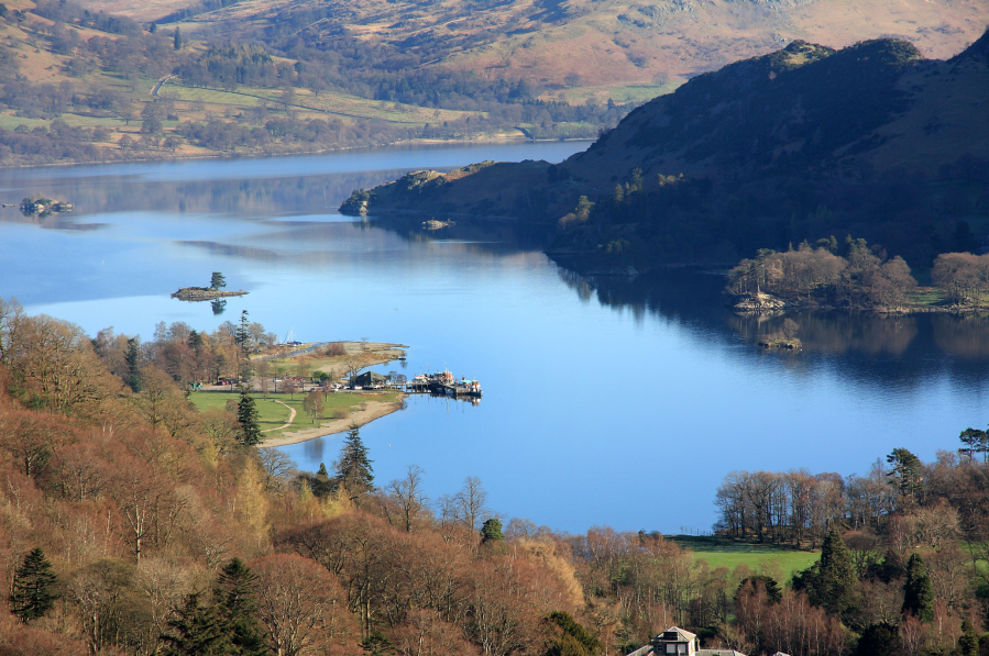
Ullswater dominates the view on the descent from St Sunday Crag.
Credit: Vivienne Crow
7. NY375141: On reaching a grassy saddle, keep left along the clearer path. Striding out high above Grisedale, you eventually drop through a small gate in a wall at Thornhow End. Swing left, descending steeply again.
8. NY386157: At the bottom of the drop, with a gate just a few metres ahead, turn right along the path through Glenamara Park. After fording Hag Beck, keep straight on beyond a gate in a wall. The next gate leads into woods near the edge of Patterdale. Bear right at an early fork. Turn right along a broad track to drop into Patterdale, opposite the White Lion Inn.
Further information
PUBLIC TRANSPORT: Grasmere is served by bus 555 (Lancaster/Kendal to Keswick); Patterdale by bus 508 (Penrith to Patterdale in winter, continuing to Windermere in summer)
TOURIST INFORMATION: www.lakedistrict.gov.uk, 0845 9010845
NEAREST YHA: Grasmere (start) and Patterdale (finish)
Discover more walks in the Lake District as mapped by The Great Outdoors’ expert contributors.


