
What is the best section of the Cumbria Way long-distance trail? For sheer beauty and drama, it’s hard to beat the Coniston to Langdale leg, argues James Forrest.
The Cumbria Way is a 73-mile walk through (obviously) Cumbria, journeying the length of the county from Ulverston to Carlisle via Coniston, Langdale, Keswick and Caldbeck. Devised by local Ramblers groups in the 1970s, it is a low-level, valley-hopping walk that delivers a visual feast of Lakeland splendour for the five or so days you’re on the trail. If you don’t have enough time to hike it all (poor you), fear not – you can easily sample the best bits as day walks.
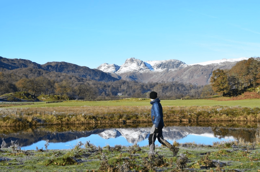
Langdale to Keswick via the remote Langstrath valley and the western shores of Derwentwater is tempting, as is the quiet remoteness of Back o’Skiddaw on the Keswick to Caldbeck leg. But perhaps the best Cumbria Way section is Coniston to Langdale – a 12-mile route packed full of iconic Lake District favourites. From the idyll of Beatrix Potter’s Tarn Hows to the mirrored reflections of Elter Water, and from the jagged skyline of the Langdale Pikes and to the cosy embrace of the Old Dungeon Ghyll pub, it’s a route that almost feels like an entire long-distance trail crammed into a day.
The Cumbria Way (Coniston – Langdale): route description
START/FINISH: Start at St Andrew’s Church in Coniston (SD302975); finish at the Old Dungeon Ghyll pub in Great Langdale (NY286061) | MAPS: OS Explorer OL7 (1:25k), OS Landranger 90 and 96 (1:50k), Harvey British Mountain Map Lake District (1:40k) | DISTANCE: 18.8km / 11.7 miles | ASCENT: 672m / 2,205ft | DURATION: 6 hours
1. SD302975: From St Andrew’s Church, head east on B5285. Turn left onto Shepherds Bridge Lane and turn right to cross bridge over Yewdale Beck. Veer left, go through gate and head north-east through fields. Pass to left of stone building and continue north-east, ascending gently. Descend briefly, continuing north and north-east through fields and on lane alongside Yewdale Beck. Next to bridge in Low Yewdale, fork right through gate and head east into Tarn Hows Wood. Head north-east through woodland. Cross small stream and follow wall to arrive at Tarn Hows Cottage. Pass to right of cottage and walk east along driveway to reach road. Turn left and head north-east and east to National Trust car park. Veer left and take path north down to tarn’s western side.
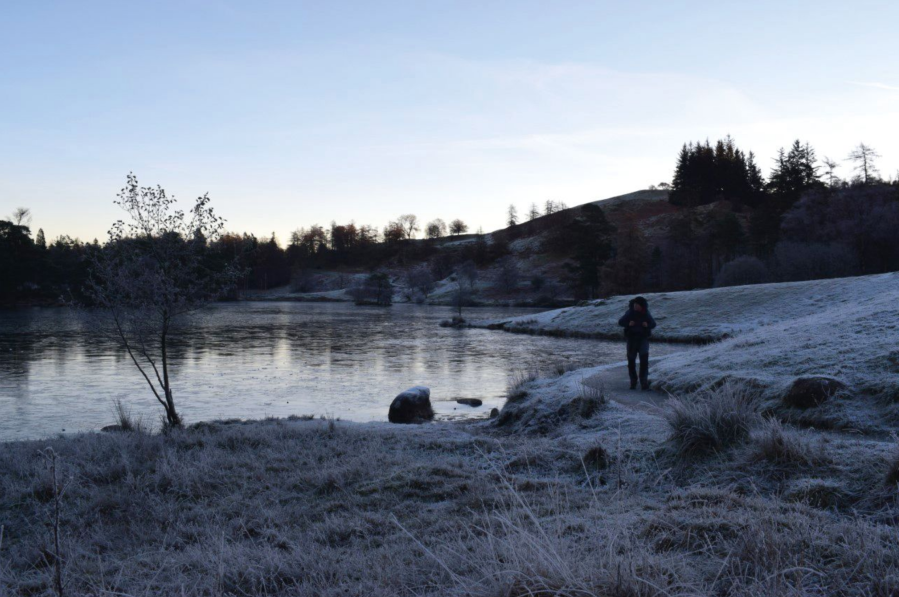
Walking around a frozen Tarn Hows.
Credit: James Forrest
2. SD327997: Head north on wide track to left of tarn and near the northern tip of tarn fork left, signposted Skelwith Bridge. Continue north beyond tarn to reach path junction beyond gate. Turn left, signposted ‘Oxenfell and Langdales’. Head north on track, passing small tarn and arriving at A593. Cross road and turn immediately right on path running parallel to road. Go through gate and veer left briefly to reach another road. Head north-west on road to arrive at High Park.
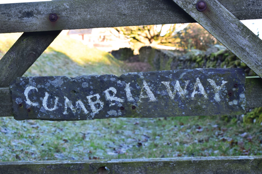
Cumbria Way sign.
Credit: James Forrest
3. NY323028: Go down drive towards farm buildings and turn right through gate before reaching them. Head east and, beyond another gate, fork left and descend through woodland to Colwith Force waterfall. Pass to right of waterfall and pick up path looping east and south-east down to road. Cross stile, turn right on road, cross bridge over stream and turn left on path next to fingerpost sign to Skelwith Bridge. Climb steps through woodland and head north-east and east to first Park Farm and then Park House. Beyond gate, continue east through field and fork left underneath electricity pylons. Go through gate, enter woodland and follow path as it loops sharp left. Fork left, descend gently north-west, pass to left of Skelwith Force and cross River Brathay at footbridge. Turn left and head north and north-west on path alongside the river and Elter Water. Skirt around northern shore of Elter Water and head north-west along river. Arrive at car park in Elterwater village.
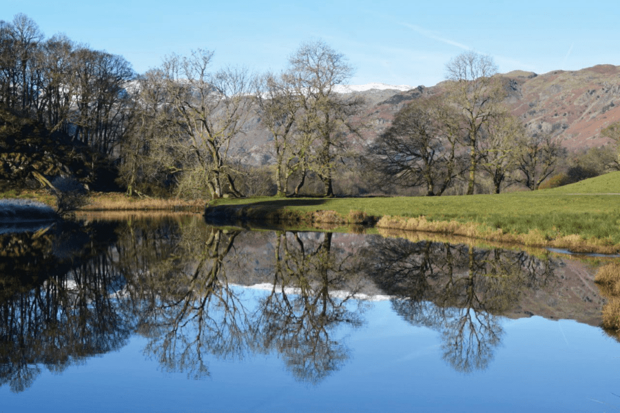
Tree reflection in River Brathay.
Credit: James Forrest
4. NY327047: Exit car park, turn left over bridge and turn immediately right up road signposted ‘Chapel Stile ½ mile’. Follow river north-west and fork right off road onto track, as waymarked. Skirt around old slate mine. Fork right next to memorial bench and cross footbridge over river. Turn left on road, pass Wainwrights’ Inn and turn left again onto rocky path signposted ‘Baysbrown Campsite’. Head west on track before picking up road passing to right of Thrang Farm. Continue north-west, go through gate, skirt left next to houses, cross small stream and loop left next to large piles of slate. Cross New Bridge and turn right to follow Langdale Beck north-west on wide track to Oak Howe, ignoring bridge to right. Pass to left of buildings, fork right and traverse west around northern tip of Lingmoor Fell. Descend gently towards Side House. Cross small footbridge and pass to right of building, heading north on driveway. Cross bridge over Great Langdale Beck and arrive at road. Turn left and then immediately right through Stickle Ghyll car park. Pass in front of Sticklebarn pub, pass next to New Dungeon Ghyll and loop west. Traverse the fellside on a good path, which runs parallel to the valley, and finally – after passing a white cottage – turn left down to Old Dungeon Ghyll.
Further information
PUBLIC TRANSPORT: Take a train to Windermere and then Stagecoach’s 505 bus to Coniston. For your return, take Stagecoach’s 516 bus from Dungeon Ghyll to Kendal.
TOURIST INFORMATION: Visit Cumbria, 016973 22474 (finish)
NEAREST YHA: Coniston Holly How (start) and Langdale (finish)
Discover more walks in the Lake District as mapped by The Great Outdoors’ expert contributors.


