
John Gillham ruminates on the lost villages and settlements of the Lake District on this High Street walk
If I had looked across Mardale Head to the mountains of Kidsty Pike in 1936 I would have seen the village of Mardale Green, which consisted of a pub, the Dun Bull, a church, surrounded by yew trees and some whitewashed cottages. The lake would have had natural beaches where primroses fringed the banks. In his Coast-to-Coast book, A. Wainwright reminisced of hedgerows sweet with flowers and wild roses. But it’s the 21st century and Mardale has crumbled beneath the wall of water, which formed when the valley was dammed to feed Manchester. I took a walk of 22km/13.5 miles, with 1010m/3310ft of ascent, taking around 7-8 hours, to explore this part of the Lake District.
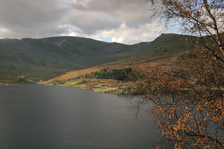
Haweswater
The autumn and winter months are a lovely time in Mardale. Haweswater is full so there are no sterile shorelines. The winter snows had yet to arrive on the day of my visit, and the larches still glowed with fiery red and gold, contrasting dramatically with black clouds moving across blue skies.
The black clouds were disappearing fast by the time I passed the beautiful tarn of Small Water and only white fluffy ones were left at the high pass of Nan Bield. I remembered the time I arrived here from Kentmere when doing the Lakeland to Lindisfarne long distance walk some years ago. Visibility was zero and the gale-blown rain horizontal. My wife’s knees had almost given up and there were several more miles to go to Bampton Grange in the north.
Today I looked across Kentmere and its small reservoir to one of my favourite mountains, Ill Bell, which like its name suggests is bell-shaped and dressed with fine steep rocks. Confusingly my next peak was also called Ill Bell but this one was Mardale Ill Bell. The peak, while not as well sculpted as its Kentmere neighbour, offers splendid views back down Mardale, where the yawning stretch of Haweswater seems like an extension of Small Water.
The wide main path carries on directly to High Street but I chose a neat little left fork which rounds the Kentmere side to visit the great stone beacon on Thornthwaite Crag.
The High Street Roman Road
The onward journey to High Street is by way of the Roman road, which linked forts at Bracovum (Ambleside) and Galava (Penrith), then a right fork path by the ridge wall. The top of High Street, the mountain, is quite extensive and it’s no surprise that this used to be known as Racecourse Hill, a name dating back to the times when the locals from the lost village of Mardale Green used to congregate here for an annual festival, which included horse racing. The same horses were also used to carry ale and provisions for the revelry.
You might also enjoy our walk guide to Kentmere Pike and Harter Fell, or perhaps Haycock and Caw Fell.
Wainwright’s Coast-to-Coast walk took me along the Straights of Riggindale to the rocks of Kidsty Pike. I could have made a direct descent to Haweswater but I had time for a longer walk so I headed over Rampsgill Head, which gives fine views down the deep scoop of Martindale, and rejoined the Roman road to the rounded grass summit of High Raise. Here it was time to leave the ridge and a narrow path led me over the cairn on Low Raise. All traces of a path are lost north of Bason Crag and it is best to round the coombe, then head north-eastwards down the rough, grassy slopes north of Laythwaite Crags. If visibility is good, head in the direction of the white radar dome that crowns Great Dun Fell on the horizon. By doing this I located a winding rutted track that led me down to the footbridge over Measand Beck, a lively stream with some waterfalls peeping through the rowan bushes and thorn trees.
It was fairly late by the time I reached the ‘lake path’. I suppose lake path is a misnomer as it climbs quite high at Flakehow Crags and cuts a corner by climbing over the shoulder of the Rigg. Mine was the last car left in the car park but the lateness mattered not a jot. I was staying at the Haweswater Hotel, where my wife, a nice bottle of claret and a juicy steak were waiting to reward my efforts.
ROUTE DESCRIPTION
- Through gate at back of car park take middle path climbing WSW past Small Water up to Nan Bield Pass
- Turn R over Mardale Ill Bell then take fainter L fork track along Kentmere edge to reach tall cairn on Thornthwaite Crag.
- Retrace steps but continue along Roman road before taking R fork over summit of High Street then down to Straights of Riggindale.
- Fork R to Kidsty Pike summit then double back L over Rampsgill Head and High Raise.
- Head NE over Low Raise and Low Grain to the top of Bason Crags then head NE down the rough, grassy slopes north of Laythwaite Crags to locate winding grass track at Measand End. On reaching footbridge at Measand Beck follow narrow streamside path down to lakeside path.
- Turn R following path back to Mardale Head. Turn L over footbridge to car park.

John Gillham ruminates on the lost villages and settlements of the Lake District on this High Street walk
If I had looked across Mardale Head to the mountains of Kidsty Pike in 1936 I would have seen the village of Mardale Green, which consisted of a pub, the Dun Bull, a church, surrounded by yew trees and some whitewashed cottages. The lake would have had natural beaches where primroses fringed the banks. In his Coast-to-Coast book, A. Wainwright reminisced of hedgerows sweet with flowers and wild roses. But it’s the 21st century and Mardale has crumbled beneath the wall of water, which formed when the valley was dammed to feed Manchester. I took a walk of 22km/13.5 miles, with 1010m/3310ft of ascent, taking around 7-8 hours, to explore this part of the Lake District.
Haweswater
The autumn and winter months are a lovely time in Mardale. Haweswater is full so there are no sterile shorelines. The winter snows had yet to arrive on the day of my visit, and the larches still glowed with fiery red and gold, contrasting dramatically with black clouds moving across blue skies.
The black clouds were disappearing fast by the time I passed the beautiful tarn of Small Water and only white fluffy ones were left at the high pass of Nan Bield. I remembered the time I arrived here from Kentmere when doing the Lakeland to Lindisfarne long distance walk some years ago. Visibility was zero and the gale-blown rain horizontal. My wife’s knees had almost given up and there were several more miles to go to Bampton Grange in the north.
Today I looked across Kentmere and its small reservoir to one of my favourite mountains, Ill Bell, which like its name suggests is bell-shaped and dressed with fine steep rocks. Confusingly my next peak was also called Ill Bell but this one was Mardale Ill Bell. The peak, while not as well sculpted as its Kentmere neighbour, offers splendid views back down Mardale, where the yawning stretch of Haweswater seems like an extension of Small Water.
The wide main path carries on directly to High Street but I chose a neat little left fork which rounds the Kentmere side to visit the great stone beacon on Thornthwaite Crag.
The High Street Roman Road
The onward journey to High Street is by way of the Roman road, which linked forts at Bracovum (Ambleside) and Galava (Penrith), then a right fork path by the ridge wall. The top of High Street, the mountain, is quite extensive and it’s no surprise that this used to be known as Racecourse Hill, a name dating back to the times when the locals from the lost village of Mardale Green used to congregate here for an annual festival, which included horse racing. The same horses were also used to carry ale and provisions for the revelry.
You might also enjoy our walk guide to Kentmere Pike and Harter Fell, or perhaps Haycock and Caw Fell.
Wainwright’s Coast-to-Coast walk took me along the Straights of Riggindale to the rocks of Kidsty Pike. I could have made a direct descent to Haweswater but I had time for a longer walk so I headed over Rampsgill Head, which gives fine views down the deep scoop of Martindale, and rejoined the Roman road to the rounded grass summit of High Raise. Here it was time to leave the ridge and a narrow path led me over the cairn on Low Raise. All traces of a path are lost north of Bason Crag and it is best to round the coombe, then head north-eastwards down the rough, grassy slopes north of Laythwaite Crags. If visibility is good, head in the direction of the white radar dome that crowns Great Dun Fell on the horizon. By doing this I located a winding rutted track that led me down to the footbridge over Measand Beck, a lively stream with some waterfalls peeping through the rowan bushes and thorn trees.
It was fairly late by the time I reached the ‘lake path’. I suppose lake path is a misnomer as it climbs quite high at Flakehow Crags and cuts a corner by climbing over the shoulder of the Rigg. Mine was the last car left in the car park but the lateness mattered not a jot. I was staying at the Haweswater Hotel, where my wife, a nice bottle of claret and a juicy steak were waiting to reward my efforts.
ROUTE DESCRIPTION
- Through gate at back of car park take middle path climbing WSW past Small Water up to Nan Bield Pass
- Turn R over Mardale Ill Bell then take fainter L fork track along Kentmere edge to reach tall cairn on Thornthwaite Crag.
- Retrace steps but continue along Roman road before taking R fork over summit of High Street then down to Straights of Riggindale.
- Fork R to Kidsty Pike summit then double back L over Rampsgill Head and High Raise.
- Head NE over Low Raise and Low Grain to the top of Bason Crags then head NE down the rough, grassy slopes north of Laythwaite Crags to locate winding grass track at Measand End. On reaching footbridge at Measand Beck follow narrow streamside path down to lakeside path.
- Turn R following path back to Mardale Head. Turn L over footbridge to car park.


