
Daniel Neilson is thrilled by a day on the low but wild Ochils
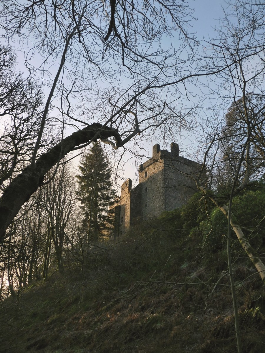
I was up in Dunfermline visiting a friend for a couple of days. As he went off to work in Alloa, he dropped me in Dollar, jealous of the day I had before me. After picking up a ‘manwich’ in a chi chi deli in Dollar (of which there seems to be at least three) I walked through the gorges to Castle Campbell, once called Castle Gloom. I rather wish they’d kept the former name. I discussed my route with the chatty castle warden. Whitewisp Hill–Tarmangie Hill–Andrew Gannel Hill– Ben Cleuch–Ben Ever–Alva. We sounded as though we were discussing a wayward route on the Northern Line.
My 1998 Harvey Superwalker map describes the escarpment of the Ochils as “one of the most striking profiles in Britain… There are few isolated, eye-catching summits, but the 20km line of 40-degree slopes never fails to impress.”
I thought it a tad overly put when I considered them on the map. But as I puffed up Whitewisp Hill and on to Ben Cleuch, thinking that it still takes a fair amount of effort, I understood its wildness, that feeling I’d experienced on the remote Cairngorm hills. I could see for many miles: Grangemouth refinery, the winding Forth, Stirling Castle, the whiteness of the higher Perthshire hills and the marching wind turbines. I juggled a video camera, still camera and iPhone (hey, I’m the Digital Editor and it’s my job – the video you can see on tgomagazine.co.uk).
Don’t underestimate the glens and bens of the Ochils. With a snowy covering, full winter gear would be needed and I’d take a different route down into Alva than mentioned here. Roger Smith, who lived in Alva, suggests following the grassy path down Ben Ever’s south-west ridge to join a bulldozed track that twists down a series of zig-zags. At the final sharp left turn go straight ahead on a path leading into Alva Glen.
ROUTE DESCRIPTION
- From Dollar, follow footpath sign to Castle Campbell. At the castle, follow the path north (not to King’s Seat), cross the burn and walk up the path SE to a farmhouse and turn N and NNE alongside the burn – on the right, then on left. Where the path meets the plantation, climb up NW to Whitewisp Hill (another route is to climb earlier to Saddle Hill).
- From the cairn on Whitewisp Hill, follow the clear path to Tarmangie Hill (summit is slightly off path) and then descend NW to gate and then W to Skythorn Hill and WSW to Andrew Gannel Hill and a spectacular viewpoint.
- Stay on L of fence and climb W & NW to Ben Cleuch. Descend on clear path to where three fences meet. Climb stile and then path to summit of Ben Ever (there’s another lower path that doesn’t go to the summit).
- Follow broad ridge (Millar Hill) S to spur. Descend steeply W to gap. There’s a clear path that goes into gully and out. It is very steep and loose – not for a winter walk. SW to another spur marked Wood Hill (525m spot height). Pick up path on the south of burn and into Silver Glen. It’s very steep here in places. Pick a path either through the wood or into glen. Cross Silver Burn and follow clear path into Alva. Regular buses to Dollar and Alloa.

Daniel Neilson is thrilled by a day on the low but wild Ochils
AS I STOOD at the end of the ridge on Millar Hill I let out a whoop. The snow swirled around me, the wind knocked me forward and back, clouds enveloped me in disorientating grey before opening up vast views across the Forth on which the bright reflection of the sun filled my vision with a blinding golden glow. I yelled out again, enjoying the snow slapping at my face, almost painful. This is why we do it. I hadn’t noticed a startled walker on a path 10 metres below me. She scurried off pretending she hadn’t seen my ‘moment’, I felt rather foolish, but sod it. I was in a joyous mood. In the five hours I’d been up on the Ochils, I’d had hail, snow, wind that shook me to a standstill and a triumvirate of unsightly, and undramatic falls (the least dignified kind). But mostly I’d had winter sunshine lighting the hazy atmosphere with a glow that only happens north of the border.
I was up in Dunfermline visiting a friend for a couple of days. As he went off to work in Alloa, he dropped me in Dollar, jealous of the day I had before me. After picking up a ‘manwich’ in a chi chi deli in Dollar (of which there seems to be at least three) I walked through the gorges to Castle Campbell, once called Castle Gloom. I rather wish they’d kept the former name. I discussed my route with the chatty castle warden. Whitewisp Hill–Tarmangie Hill–Andrew Gannel Hill– Ben Cleuch–Ben Ever–Alva. We sounded as though we were discussing a wayward route on the Northern Line.
My 1998 Harvey Superwalker map describes the escarpment of the Ochils as “one of the most striking profiles in Britain… There are few isolated, eye-catching summits, but the 20km line of 40-degree slopes never fails to impress.”
I thought it a tad overly put when I considered them on the map. But as I puffed up Whitewisp Hill and on to Ben Cleuch, thinking that it still takes a fair amount of effort, I understood its wildness, that feeling I’d experienced on the remote Cairngorm hills. I could see for many miles: Grangemouth refinery, the winding Forth, Stirling Castle, the whiteness of the higher Perthshire hills and the marching wind turbines. I juggled a video camera, still camera and iPhone (hey, I’m the Digital Editor and it’s my job – the video you can see on tgomagazine.co.uk).
Don’t underestimate the glens and bens of the Ochils. With a snowy covering, full winter gear would be needed and I’d take a different route down into Alva than mentioned here. Roger Smith, who lived in Alva, suggests following the grassy path down Ben Ever’s south-west ridge to join a bulldozed track that twists down a series of zig-zags. At the final sharp left turn go straight ahead on a path leading into Alva Glen.
ROUTE DESCRIPTION
- From Dollar, follow footpath sign to Castle Campbell. At the castle, follow the path north (not to King’s Seat), cross the burn and walk up the path SE to a farmhouse and turn N and NNE alongside the burn – on the right, then on left. Where the path meets the plantation, climb up NW to Whitewisp Hill (another route is to climb earlier to Saddle Hill).
- From the cairn on Whitewisp Hill, follow the clear path to Tarmangie Hill (summit is slightly off path) and then descend NW to gate and then W to Skythorn Hill and WSW to Andrew Gannel Hill and a spectacular viewpoint.
- Stay on L of fence and climb W & NW to Ben Cleuch. Descend on clear path to where three fences meet. Climb stile and then path to summit of Ben Ever (there’s another lower path that doesn’t go to the summit).
- Follow broad ridge (Millar Hill) S to spur. Descend steeply W to gap. There’s a clear path that goes into gully and out. It is very steep and loose – not for a winter walk. SW to another spur marked Wood Hill (525m spot height). Pick up path on the south of burn and into Silver Glen. It’s very steep here in places. Pick a path either through the wood or into glen. Cross Silver Burn and follow clear path into Alva. Regular buses to Dollar and Alloa.


