

James Carron follows in the footsteps of drovers
IN ITS DAY SPITTAL of Glenmuick was a welcome refuge for travellers crossing the hills on the Capel Mounth, a vital link between Clova in the south and Ballater in the north. Established in the 15th century by the Bishop of Aberdeen, the Spittal Inn offered food, whisky and a bed for the night at the end of a long day on the road.
Today the inn is long gone and the township abandoned but the Spittal remains a popular intersection for those heading into the hills and it was from here that I began my ascent of Lair of Aldararie and Ferrowie. Pausing briefly at Glenmuick’s little visitor centre for a vending machine coffee, I left the track to Loch Muick at the next junction, by an old stone barn, and joined an initially grassy path that climbs alongside the Allt Darrarie.
Heading upstream, the burn was a delightful companion. Passing tumbling white water, rocky gorges and tranquil pools,I crossed the stream by a wooden bridge and, with caffeine still circulating my veins, rose into a secluded landscape of low heather-clad hills dotted with deep peat hags. A lone deer surveyed my progress from the security of a rocky knoll above.
Remaining with the stream until it was little more than a sliver of water snaking almost unseen through the grass, I broke off across open ground, heading directly for the summit of Black Hill of Mark. There is no path as such over the slope of heather and grass so I hopped from one deer track to another until I finally found the top.
Walking south, I picked up a vague path to neighbouring Murley. The route crosses peaty ground where a fascinating array of footprints left by birds and animals marks the passing of the area’s native inhabitants. Red deer, grouse and mountain hare were all represented. Fortunately I had come on a clear day for, despite following the county boundary, there is no fence line or wall to delineate the route and the largely featureless terrain would provide a real test of navigation in poor visibility.
My route descended into deeper, muddier hags ahead of the ascent on to The Witter, the last lump before Lair of Aldararie. Sitting above Coire Gorm, Aldararie’s broad summit surveys Glen Doll to the west and the craggy valley leading up to Bachnagairn is an easily identifiable gouge on the landscape.
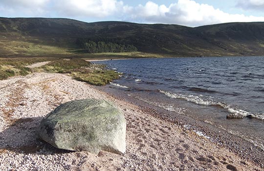
There were more peat hags to negotiate as I dropped into the col at the top of the Capel Burn ahead of the last real climb of the day, on to Ferrowie where I was greeted by a tall stone cairn complete with its own buttress wall. I paused briefly in its lea for a wellearned breather and a cuppa. Across Loch Muick, the unmistakable profile of Lochnagar cut across the skyline.
After so much pathless walking, it was a treat to join a well-established track for the next leg of the walk. The route descended north, joining another track lower down. I branched left at the junction and the track dropped in earnest to meet the Capel Mounth, my road home.
As I walked north, dipping briefly before enjoying a well-graded ascent over the lower slopes of Black Hill, I cast my thoughts back to the hardy travellers of old for whom this exposed upland route was a primary means of communication, the people and animals who trod its path in good weather and bad. Heading back to the car park, I surveyed the remains of the old township, a place where people had come and gone for centuries. Abandoned 200 years ago, this once thriving community is now little more than a few mounds of lichen-encrusted stone in a grassy field.
ROUTE DESCRIPTION
- From the car park, follow track to Spittal of Glenmuick Visitor
- Centre and continue round metal gate to junction. Turn left at old stone barn and take path following Allt Darrarie upstream, crossing wooden bridge higher up.
- Follow stream E on narrow path, then bear S, ascending open hillside to summit of Black Hill of Mark.
- Continue S over Murley, following vague path, then bear W to summit of Lair of Aldararie.
- Descend NW into col at top of Capel Burn and climb to summit of Ferrowie, marked by tall stone cairn.
- Join track and descend N to junction. Turn left and follow track down to meet Capel Mounth.
- Turn R and follow Capel Mounth north, rising over western flank of Black Hill before descending into Glen Muick.
- Turn right, follow track north to visitor centre and continue back to car park.

James Carron follows in the footsteps of drovers
IN ITS DAY SPITTAL of Glenmuick was a welcome refuge for travellers crossing the hills on the Capel Mounth, a vital link between Clova in the south and Ballater in the north. Established in the 15th century by the Bishop of Aberdeen, the Spittal Inn offered food, whisky and a bed for the night at the end of a long day on the road.
Today the inn is long gone and the township abandoned but the Spittal remains a popular intersection for those heading into the hills and it was from here that I began my ascent of Lair of Aldararie and Ferrowie. Pausing briefly at Glenmuick’s little visitor centre for a vending machine coffee, I left the track to Loch Muick at the next junction, by an old stone barn, and joined an initially grassy path that climbs alongside the Allt Darrarie.
Heading upstream, the burn was a delightful companion. Passing tumbling white water, rocky gorges and tranquil pools,I crossed the stream by a wooden bridge and, with caffeine still circulating my veins, rose into a secluded landscape of low heather-clad hills dotted with deep peat hags. A lone deer surveyed my progress from the security of a rocky knoll above.
Remaining with the stream until it was little more than a sliver of water snaking almost unseen through the grass, I broke off across open ground, heading directly for the summit of Black Hill of Mark. There is no path as such over the slope of heather and grass so I hopped from one deer track to another until I finally found the top.
Walking south, I picked up a vague path to neighbouring Murley. The route crosses peaty ground where a fascinating array of footprints left by birds and animals marks the passing of the area’s native inhabitants. Red deer, grouse and mountain hare were all represented. Fortunately I had come on a clear day for, despite following the county boundary, there is no fence line or wall to delineate the route and the largely featureless terrain would provide a real test of navigation in poor visibility.
My route descended into deeper, muddier hags ahead of the ascent on to The Witter, the last lump before Lair of Aldararie. Sitting above Coire Gorm, Aldararie’s broad summit surveys Glen Doll to the west and the craggy valley leading up to Bachnagairn is an easily identifiable gouge on the landscape.
There were more peat hags to negotiate as I dropped into the col at the top of the Capel Burn ahead of the last real climb of the day, on to Ferrowie where I was greeted by a tall stone cairn complete with its own buttress wall. I paused briefly in its lea for a wellearned breather and a cuppa. Across Loch Muick, the unmistakable profile of Lochnagar cut across the skyline.
After so much pathless walking, it was a treat to join a well-established track for the next leg of the walk. The route descended north, joining another track lower down. I branched left at the junction and the track dropped in earnest to meet the Capel Mounth, my road home.
As I walked north, dipping briefly before enjoying a well-graded ascent over the lower slopes of Black Hill, I cast my thoughts back to the hardy travellers of old for whom this exposed upland route was a primary means of communication, the people and animals who trod its path in good weather and bad. Heading back to the car park, I surveyed the remains of the old township, a place where people had come and gone for centuries. Abandoned 200 years ago, this once thriving community is now little more than a few mounds of lichen-encrusted stone in a grassy field.
ROUTE DESCRIPTION
- From the car park, follow track to Spittal of Glenmuick Visitor
- Centre and continue round metal gate to junction. Turn left at old stone barn and take path following Allt Darrarie upstream, crossing wooden bridge higher up.
- Follow stream E on narrow path, then bear S, ascending open hillside to summit of Black Hill of Mark.
- Continue S over Murley, following vague path, then bear W to summit of Lair of Aldararie.
- Descend NW into col at top of Capel Burn and climb to summit of Ferrowie, marked by tall stone cairn.
- Join track and descend N to junction. Turn left and follow track down to meet Capel Mounth.
- Turn R and follow Capel Mounth north, rising over western flank of Black Hill before descending into Glen Muick.
- Turn right, follow track north to visitor centre and continue back to car park.


