
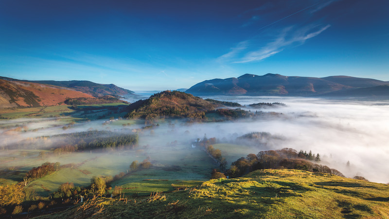
Cloud inversions are among the most magical weather phenomena that a hillwalker can experience – and autumn brings your best chance of seeing one. We asked MWIS forecaster Garry Nicholson to share his inversion bagging advice.
Ever listened to Joni Mitchell singing I’ve looked at clouds from both sides now and thought: ‘she must have been a wild camper’? If you spend plenty of time pitched up high in the hills, you might well have experienced one of those serendipitous mornings when you unzip the tent door and find yourself gazing down on a bank of cloud. Every wild camper secretly wants to wake up to a cloud inversion – but how do you spot one coming? With difficulty, according to Mountain Weather Information Service (MWIS) forecaster Garry Nicholson.
“Forecasting the height of cloud tops can be one of the trickier aspects of mountain forecasting,” he says. “Those tantalising moments when you reach a summit, can almost see the sun above you, but you’re still just in the fog. Oh, so frustrating – sometimes all you need is a taller trig point to stand on!”
While there’s no way of predicting a cloud inversion with cast-iron accuracy, there are certain combinations of weather conditions that make this stunning phenomenon more likely. Here’s what to look for when you’re scanning the mountain forecast.
Temperature inversions
In normal meteorological conditions, temperatures fall steadily with increasing height. Cloud inversions are so called because they represent a reversal of that standard pattern.
“This is a ‘stable’ atmosphere, where air is gently descending, and warming through compression,” explains Garry. “By contrast, an unstable situation would see a more rapid fall of temperature with height.”
While ‘stability’ might not usually be the first thing you’d look for in a weather forecast, it’s an essential ingredient for a spectacular summit view.
High pressure
One of the strongest indicators of an upcoming cloud inversion is high pressure in the nearby area that remains almost stationary for an extended period of time. “When high pressure exists, this sets in motion the gentle descent of air mentioned above,” says Garry. “If the descent occurs for a few days, it often reaches the level to interact with our highest mountain tops, placing them above an inversion.”
High moisture levels
The combination of high pressure and moisture is a good recipe for cloud inversions.
“Where there is sufficient moisture present in the lower layers of the atmosphere, this can become trapped beneath the inversion, whilst the air above dries out as it warms,” says Garry. “Air with high low-level moisture loadings usually originate from the south at all times of year, especially if they have travelled toward Britain over the sea for some time. Northerly sources are less moist, and don’t saturate as easily, but can help to saturate pre-existing humid air.”
Calm conditions
Most of us associate cloud inversions with still, calm days. Strong winds are incompatible with inversions – but a light breeze can actually boost their likelihood. “A gentle amount of wind is useful, just to keep supplying enough moisture,”Garry explains.
Look for slow-moving weather patterns. These create ideal conditions for inversions, Garry adds, “because the air doesn’t get moved on or mixed up too easily, and the existing amounts of moisture are more or less maintained.”
Longer nights
Wild camping might be a tad more comfortable in the summer months – but you’re more likely to wake up to a cloud-tastic sunrise if you sleep out later in the year.
“Inversions are more common in the autumn and winter, because the longer nights allow for a greater cooling of the air, meaning less moisture content is needed to saturate it, and more readily allowing foggy bottoms to form,” explains Garry. “The lower winter sun struggles to warm and evaporate inversion layers, which can keep them in place all day for several days under quiet weather patterns.”
An absence of fronts
A weather front is a transition zone between two different air masses. Fronts are often associated with turbulence – and that’s bad news for inversion-hunters.
“If a frontal system comes through, it would force a change of air mass, and the delicate balance of temperature and moisture currently in existence would be lost,” says Garry. “Changes in airflow direction, wind strength, or the overall pressure pattern will all spoil the inversion environment, either by dispersing the cloud or by lifting it into higher layers which then sit on or above the mountains.”
Finally, bear in mind that some locations are more prone to cloud inversions than others. High peaks encircling large bodies of water create particular hotspots. Paying attention to how weather patterns interact with topography can boost your chances of catching a magical inversion.
- Check out the MWIS blog for more insights into cloud inversions and other magical weather phenomena.
- You can get a more detailed insight into the mountain weather forecast from MWIS forecast videos.


