
In this extract from Rocks and Rain, Reason and Romance: The Landscape, History and People of the Lake District by David Howe, published today, the author explores the ice-bound past of the Lakeland landscape we know and love.
Extract from Chapter 12: Ice
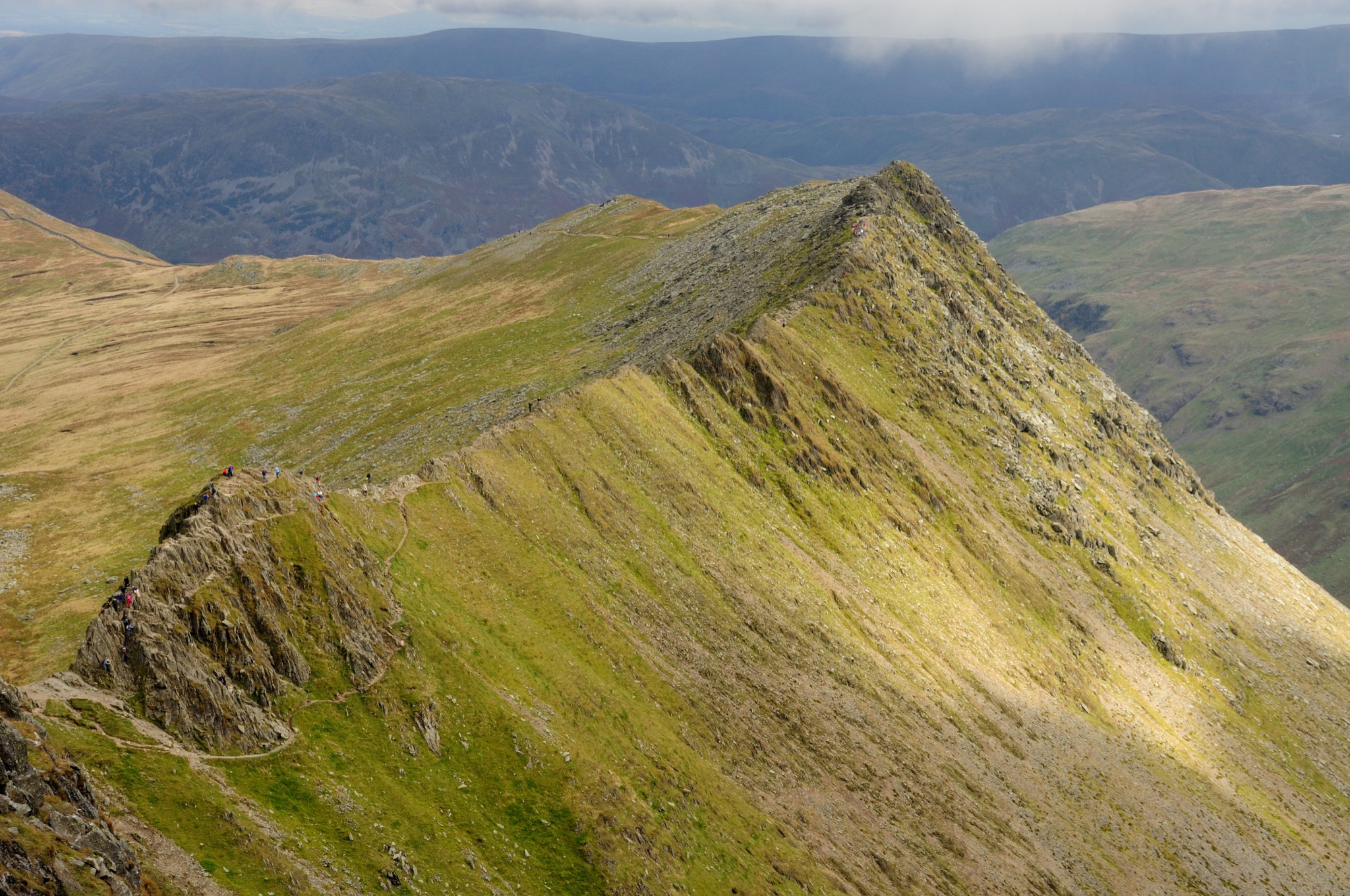
I’d forgotten how narrow the path and sharp the drop is on either side of Striding Edge. It’s been several years since I last took the track from Patterdale to climb the summit of Helvellyn. Maybe it’s an age thing, but I’m feeling a little anxious as I peer down to the black waters of Red Tarn to my right and the even steeper fall to Nethermost Cove on my left. Thankfully the wind is light, the clouds are high, and I’ve forgotten the story of Charles Gough and his little dog, Foxie.
All around me are the explosive rocks of the Upper Borrowdale Volcanic Group. The sharp, precipitous divide of Striding Edge itself is an arête. This is a glacial feature, and although the rocks on which I am carefully edging my way along may be nearly 500 million years old, the carving of the arête is, geologically speaking, new and fresh.
Striding Edge was honed during the last Ice Age, a time when the Lake District, along with the rest of northern Europe, including most of the British Isles, was covered in a vast ice sheet, up to 2,300 feet or 700 metres thick in parts. The present drama of the Lake District is the result of tough, resilient rocks formed half-a-billion years ago being sculpted by ice, wind and rain, but particularly ice.
Every few hundred million years, planet Earth chills and suffers a major ice age. There have been at least five over the last 2 or 3 billion years. The most recent of these is known as the Quaternary Ice Age. It’s the one that has shaped the landscape of the British Isles as we currently know it and, technically, is the one in which we still find ourselves today. It began about 2.5 million years ago and it defines the present major geological period.
“If I was standing on Helvellyn all that time ago I might find myself on an outcrop of rock that is just managing to pierce the ice and snow”
What causes ice ages is still a matter of debate. Likely culprits include changes in the Earth’s orbit and axis around the sun, the Earth’s 22,000-year cyclical wobble, the movement and position of the continents caused by plate tectonics, how the ocean’s currents switch and swirl between and around continents, and how much carbon dioxide and methane there is in the atmosphere. It’s likely that there are complex interactions between all these elements. But when temperatures drop and the snows begin to fall, and when the summers get colder and not all the winter snows melt, glaciers form and grow, and ice sheets begin to spread. And just over two million years ago one of these chilly combinations began to take shape.
To complicate matters further, during any one major ice age, there can be a number of warm bursts. These interglacial warm phases can last tens of thousands of years, sandwiched between the long, very cold spells. Over the last 2.5 million years, the Quaternary ice sheets have therefore waxed and waned over the British Isles many times.
© Stewart Smith Photography / Shutterstock
Today, we are in one of the relatively warm interglacial periods, but with the distinct possibility that another cold glacial spell will sweep the planet in the next 30-odd thousand years, although of course man-made global warming is the new joker in the Earth-history pack and who knows quite what will happen next.
In Britain and northern Europe, the biggest of the Quaternary ice advances happened around 450,000 years ago. It is known as the Anglian Ice Sheet. It stretched as far south as the current Thames and Severn valleys in a line running roughly between London and Bristol. If I was standing on Helvellyn all that time ago I might find myself on an outcrop of rock that is just managing to pierce the ice and snow. All around me, as far as the eye could see, would be glaciers, ice sheets and the frost-shattered peaks of the Cumbrian mountains.
If the Anglian glaciation was the biggest of the Quaternary ice advances, the most recent was the Devensian, which began around 100,000 years ago. This last ice advance began, like all ice advances, when global temperatures once again began to plummet. In northern Europe, the winter snows fell more heavily, especially over the mountains. The summers were no longer warm enough to melt the winter drifts. The snows compacted and slowly turned to ice, and ice – like water – flows downhill, but slowly, glacially slow.
“Prior to the ice and glaciers, the Lake District was a domed land weathered by rain and eroded by rivers. The hills and valley would have had a more rounded, softer feel to them. But the cold, ice and snow changed all that”
Over the mountains of the Lake District, Wales, the Pennines, Scotland and Scandinavia the rivers of ice glided and ground their way down the pre-existing river valleys, out onto the plains, merging to form vast ice sheets. Under their own weight, the sheets spread out in all directions, covering much of the land, and then out over the dry Irish and North Sea basins. At their most extensive, these Devensian ice sheets formed a wilderness of white from Ireland to Norway. More modest than some of its Quaternary predecessors, nevertheless it still covered the northern half of the British Isles. Its last maximum was around 18,000 years ago and its icy reach just about touched the northern fringes of the Midlands plains.
To the south of the ice sheet, cold, wind-blasted tundra lands stretched from southern Ireland, across southern England, the lands that are now the southern North Sea, across to the continental plains of Europe. At its peak, there was so much water locked up in the huge ice caps that sea level was over 325 feet (100 metres) lower than it is today. There was no Irish or North Sea, only ice to the north and tundra to the south.
As the climate continued to cool, more and more snow fell over the mountains of the Lake District. Glaciers began their inexorable flow down the valleys. Above the rivers of ice, frozen mountain peaks shattered in the extreme frosts. The scree-littered summits of Scafell Pike and Bow Fell offer fine examples of the power of frost and ice to break up even the hardest of rocks. Much of the scree tumbled down the mountains, skirting the slopes. And some of it eventually fell onto and into the ice below.
“Where two deep-sided corries cut back and intersect each other, a sharp edge or rocky dividing line is created. This is known as an arête, and it is along the Striding Edge arête that I am precariously walking as I make my way towards the summit of Helvellyn”
Thus, the glaciers became armed with the splintered, fractured remains of the mountain summits. With their rocky cargo, they could now scour and scrape, chisel and gouge, smooth and polish, file and flow their way down the old river valleys and slopes, accentuating their width and depth. Along many of the valley bottoms today you can see massive outcrops of rock that bear evidence of the glacier’s rasping flow. The rocks are relatively flat and ice-smoothed. But many are scratched by hundreds of fine lines all running in close parallel along the axis of the valley. These are known as ‘striations’, lines etched by the rocky remains entombed at the base of the slow-moving ice.
And on the glaciers flowed, joining forces with other frozen rivers, to form massive ice sheets until eventually they slipped and slid across the plains and river basins, carrying their booty of ground rock and shattered stone plundered from far and wide.
Let’s just pause a moment and retrace the path of these glaciers as they flowed slowly down from their mountain heights. It was as these rivers of ice made their journey that much of the mountain scenery we see today was shaped. Prior to the ice and glaciers, the Lake District was a domed land weathered by rain and eroded by rivers. The hills and valley would have had a more rounded, softer feel to them. But the cold, ice and snow changed all that.
The heads of the valleys where the glaciers were born carve great scoops into the high mountain sides. There they formed deep hollows known as ‘corries’ or ‘cwms’. Today, many of these mountain bowls are filled with water creating the high tarns that delight the fell walker. Stickle Tarn, Blea Water in the High Street fells, Grisedale Tarn, Angle Tarn. When the clouds are low and the light is grey, there is a sense of mystery as you come across a tarn resting quiet, timeless and still in the misty mountain air.
As several glaciers can form around a mountain’s summit, a number of corries can be scooped and scraped around one peak. Where two deep-sided corries cut back and intersect each other, a sharp edge or rocky dividing line is created. This is known as an arête, and it is along the Striding Edge arête that I am precariously walking as I make my way towards the summit of Helvellyn. Further north, the very name of Sharp Edge on Blencathra tells you of its glacial origins.
Rocks and Rain, Reason and Romance: The Landscape, History and People of the Lake District by David Howe (Saraband, £9.99) is published today, 28 March 2019.


