
You can’t get much more ‘classic’ than this fine circuit above Ambleside, which was completed by TGO’s Carey Davies… in rather less than classic weather
The Fairfield Horsehsoe is a classic walk indeed – so classic, it even has its own Wikipedia page. There are only a handful of British walking routes that can lay claim to this honour. The Pennine Way and other famed national trails have very nice, long pages with lots of pictures. The Yorkshire Three Peaks has got one. But after that, we’re down to passing mentions and sub-headings. ‘Ring of Steall’ redirects you to a page on the Mamores; the Cuillin traverse is a mere sub-section on the Cuillin. Among the other horseshoe walks, the same fate is given to the Snowdon Horseshoe – a title but no page – while the walk over the Càrn Mòr Dearg Arête only gets an oblique mention. A search for the Langdale Horseshoe brings up a page on the town of Langdale, British Columbia.
Now, I’m not saying Wikipedia is the final arbiter of all human knowledge. We all know the listings on this free-to-edit online encyclopaedia can have a bendy relationship with reality. But I think there is a point somewhere in all this. Why is it that some of our most mighty and dramatic mountain rounds go without representation on such a popular information trove, when a relatively short and straightforward walk, an amble by comparison, has a page all to itself?
The answer, I think, has a lot to do with Ambleside. One of the most frequented tourist hubs in one of the UK’s most popular tourist regions, it’s also the starting point of the Fairfield Horseshoe (walking it anti clockwise.) Consequently, this walk – made even more alluring by its relative ease – is one of the most heavily trod in Britain; more popular, some would argue, than its virtues merit. Large sections of path along the route have become the wide thoroughfares that grizzled, people-weary walkers refer to as ‘motorways,’ and would generally rather avoid. For them, perhaps, Fairfield is the Paris Hilton of the horseshoe world – well-connected, pretty, but ultimately devoid of any substance.
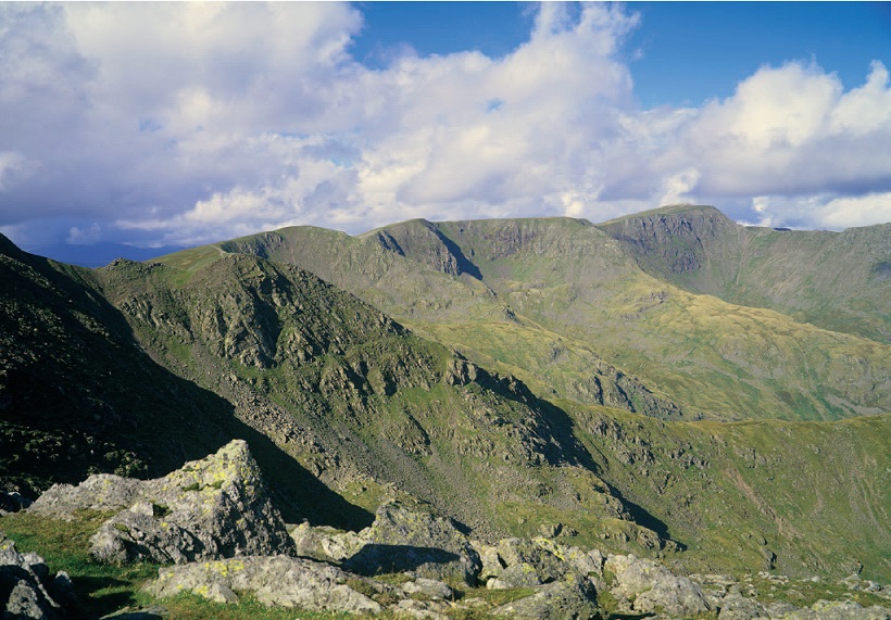
My view is slightly more forgiving. I don’t think the Fairfield horseshoe is a classic walk simply because it has the misfortunate to start amid the clicking shutters and clinking tea cups of Ambleside. It’s an elegant, satisfying mountain round that gives cinematic panoramas over a huge swathe of the Lake District, from the snaking shape of Windermere to the south, to the bold range containing Helvellyn, Nethermost Pike and Dollywagon Pike to the north, ridges flowing from it like trailing ribbons. But the best is to the west, the walk along the ridge including Great Rigg and Rydal Fell, from where you can pick out the mightiest mountains in England on the bumpy skyline: Bow Fell, Crinkle Crags, the Scafell massif, Great Gable, Pillar.
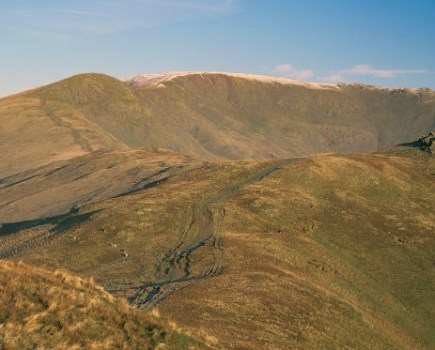
Unfortunately, when I set out to walk the Fairfield Horseshoe with photographer Dougie Cunningham for TGO, we didn’t see any of this. We started out in dense fog, which got denser as the day wore on, and gave absolutely no clue as to magnifi cence of the surroundings or the far-reaching splendidness of the views. Instead we got close-up views of dry stone walls and peat bogs. In order that you don’t have to take my word for it, we’ve cheated and included some pictures of the Fairfield Horseshoe with the sun out, despite the fact that our day was probably a more authentic experience of typical Lakeland weather. That was what we told ourselves, anyway.
We set out from Kendal on the weekend of the town’s legendary annual Mountain Festival, a sprawling gathering where outdoor folk come down from the mountains for a few days to watch films and listen to talks about people doing impressive/certifiable things, usually between equally heroic bouts of real ale consumption. I’d been watching fi lms like ‘Cold’, the tale of the first winter climb of Gasherbrum II in Pakistan by alpinists Simone Moro, Denis Urubko and Cory Richards. It was the first time one of Pakistan’s 8,000m mountains had been climbed in winter, and it looked rough. They survived some of the conditions most hostile to life, human or otherwise, on earth during their ascent – temperatures of nearly -50C, oxygen deprivation, hurricane strength winds, lethal avalanches….
Dougie and I, by contrast, were staring at the most listless, pointless, nondescript grey murk imaginable, the sort of weather that inspires no feelings except a vague sense of existential hollowness. They weren’t the most motivating conditions in which to begin a walk. At least life-threatening Himalayan storms would have been exciting on some level.
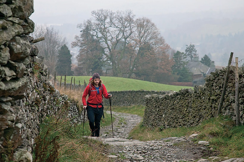
We started by getting lost in the confusing warren of backstreets and cobbled alleyways that is Ambleside (this despite the fact I had done this walk several times before) then were spat out of the urban jungle on the path to High Sweden Bridge – which wasn’t the one I was aiming for, but which goes in the right direction anyway.
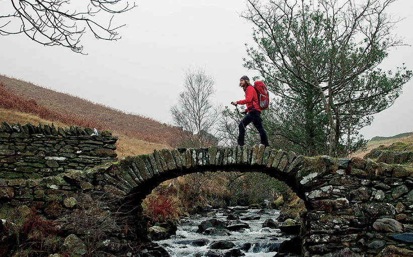
A stroll through the woods took us to the aforementioned bridge, one of those exquisitely picturesque spots – and there are a lot of them in Lakeland – that people walk to in order to simply sit for the day. Even under these ropey skies, half a dozen groups of picnickers were sat on the banks around the old packhorse bridge, watching the water tumble underneath its arch and curve round to dance on down the beck. I’m not sniffy about such behaviour – in fact, on a day like this, I was half-tempted to join them. But we pushed on up the hill instead, into the ever-thickening gloom. What sparse detail there was in the surrounding landscape faded away, and we entered the nether-realms of fog.
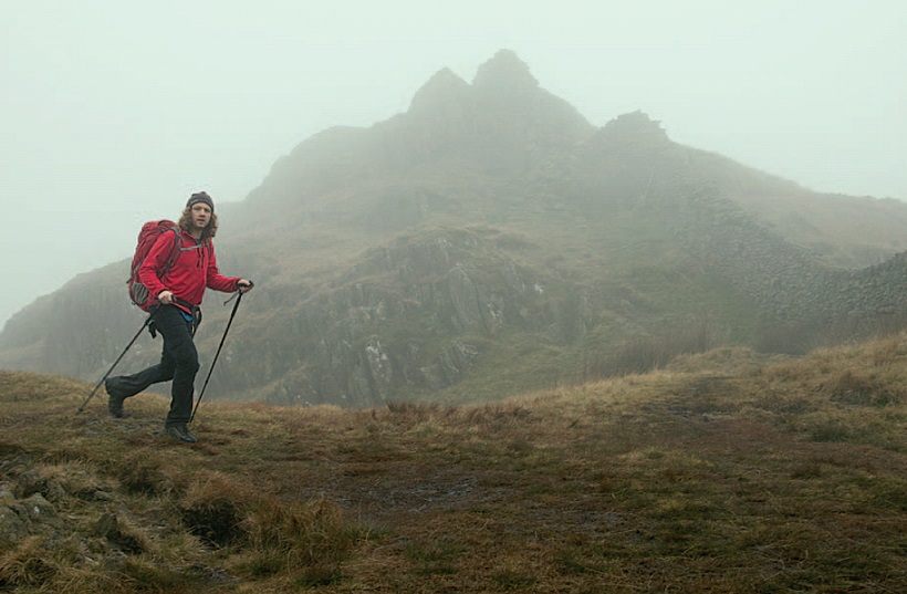
We climbed up the rocky-ish slopes of Low Pike, and before long, the visibility had shrunk around us like a cocoon closing in. Our only companion in the landscape was a dry stone wall that travelled alongside us until close to Dove Crag, a huge thing that ran unfazed by natural obstacles like rocky slopes or peaks, plotting a heedless course over the line of most resistance as if to make a point. Once over the summit of High Pike, walking alongside it became a bit Twilight Zone, a hypnotically repetitive march only broken by the cawing of a jackdaw that kept swooping out of random points in the murk.
When we finally saw some others walkers looming out of the mist, we were relieved to find they weren’t future versions of ourselves, walking back towards us in some kind of nightmare time-loop. The gloom was descending in both our heads as well, until we bumped (almost literally, given the low visibility) into a woman coming towards us. “It’s clear on the tops!” she exclaimed, in place of the usual hello. This side of the horseshoe, she elaborated, was encased in clag, but on the other, she had stridden along the ridge in glorious sunshine while looking down over a great cloud inversion. Dougie and I were a little incredulous. We had no reason not to believe her, but it didn’t feel likely, somehow (I partially suspected our mist-addled minds might have hallucinated her), and in any case the cloud would have probably enveloped the high tops by the time we got there. Nevertheless, the prospect of getting out of this grey universe was enough to buoy our spirits, and we set off with renewed purpose.
Looking up as we climbed, there did seem to be traces of blue, and soon there were teasing glimpses of the sun. For a moment on Dove Crag, we started to think we may be in luck. A window in the fog appeared, and for about 10 seconds it was like the first moments of surfacing above the cloud sea in a plane. It closed over again, snapping our view shut once more, but we were hopeful Fairfield – about 80m higher, and the tallest spot on the round – would just about give us the leg-up we needed to poke our heads into the heavens. It was not to be. If it had been cloud-free an hour or so before on top of Fairfield, there was no hint of it now. We didn’t even get the glimpses of sun we had on Dove Crag. If anything, it was denser here than it had been at any other point on the walk. The most interesting sight was a nearby sheep. We consulted the compass to make sure we took the right route off the featureless, almost flat plateau, to join the return ridge over Great Rigg and Rydal Fell.
The sunset consisted of the gloom slowly growing gloomier as what light there was drained from the grey, and the orb that gives light to the world went down somewhere unknown. We returned to Ambleside in the dark. “Great day!” said Dougie, as we changed footwear by the light of headtorch while perched on the lip of the car boot. “Yeh,” I replied, and I meant it. To be honest, it hadn’t been a great day, at least not on paper. But that’s the thing about walking in the hills – even when you reach the top and can’t see anything except unholy grey, it’s still worth it, whether it’s an 8,000m peak in the Himalayas or the high point of a relatively gentle horseshoe in the Lake District. That, at least, is something you can’t learn on Wikipedia.
Words: Carey Davies
Article images: Dougie Cunningham
Main image: Andy Stothert
Shorter routes
Not got quite so much time to spare? Click here for two shorter routes that’ll still pack a punch


