
Vivienne Crow describes one of her favourite routes in the Lakes: a Glaramara and Allen Crags walk
The ridge linking Glaramara with Allen Crags has long been one of my favourites – constantly undulating and with some rocky bits to slow progress, it’s always longer than it looks on the map. And, when a ridge is less than 2.5km long, that has to be a bonus – more time to savour its delights. The walk itself is 17km/10.5 miles in length, involves 957m/3140ft of ascent, and takes about 6-7 hours.
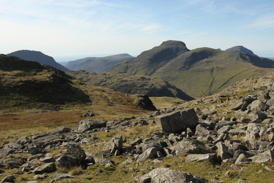
My day started in Borrowdale, following a good path climbing steadily on to Thornythwaite Fell. Across the steep-sided, glacial valley to the east were the countless crags of Rosthwaite Fell, culminating, at the lonely head of Combe Gill, in the buttress of Combe Head. As the gradient eased, I could see fresh views: Skiddaw, Blencathra and Helvellyn to the north and east, while the western vista was dominated by the more exciting, craggier faces of Great Gable, Lingmell and Great End.
Scrambling on Glaramara
Stashing away my walking poles, I scrambled up the rocks protecting the summit of Glaramara. Safe ledges, where you can rest and decide on your next move, divide the seven-metre climb into easily manageable sections. The worst is over within the first few manoeuvres, but, when I found these lower sections sheathed in ice on a winter trip a few years ago, I discovered an easy gap in the fell’s defences a few metres to the west.
Do you know how to locate yourself on a map? Here’s our guide to understanding grid references.
I can’t say for sure what it is that I love about the ridge route from Glaramara to Allen Crags: at no point could it even vaguely be described as narrow, so it’s definitely not its airiness. Maybe it’s the close proximity of dramatic summits such as Great End and Great Gable, or the feeling of being in the heart of the mountains, surrounded and dwarfed by grandeur; or simply the ridge itself, undulating, slightly rocky and with a few small, glittering pools dotted about. On this particular day, the air was startlingly clear; the detail in the views, both near and far, were unusually vivid. Even the valleys and ridges of the Forest of Bowland, across the Lancashire border, stood out clearly on the horizon.
Esk Hause
From Allen Crags, I looked straight across the vast expanse of Esk Hause to the Irish Sea. Paths come and go in all directions on the pass, promising many days of adventures on the high fells. From Esk Hause, I would normally return to Borrowdale via Grains Gill, but on my last trip, I couldn’t bear the thought of such an exceptional day ending. So, turning south-east instead, I dropped to Angle Tarn and then towards Stake Pass. From here, joining the route of the Cumbria Way, I dropped down the zig-zagging path recently repaired by the National Trust. (It still looks a little ‘raw’, incongruous even within such a verdant landscape, but it will eventually blend in better with its surroundings.)
Langstrath to Stonethwaite
Finally, I entered Langstrath, the aptly named ‘Long Valley’ – with more than four kilometres still to walk to get back to Stonethwaite. It had been a tiring day, but there was no sense of weariness in the lonely dale that evening; just an immense sense of satisfaction and continuing elation.
A GPS watch can be useful in the big hills. Here’s our guide to a few of the best models.
ROUTE DESCRIPTION
- Turn L out of car park and take lane on L. About 150m beyond the farmyard, turn R at fingerpost, signposted Burthwaite Bridge. Turn L at road and then L along Thornythwaite Farm track. After 80m, go L through kissing-gate.
- Path climbs beside wall, swings R and passes through gate on to open fell, climbing steadily. Nearing summit of Glaramara, bear R at fork. Short, easy scramble leads to summit cairn.
- Head roughly SSW at first, veering SW, across undulating ridge to Allen Crags’ summit cairn.
- Descend stony ground towards shelter below Esk Hause. Just before shelter, turn L, soon joining clear path descending SE.
- Immediately after Angle Tarn’s outlet stream, turn L along mostly level, grassy path (mostly NE).
- About 2.1km beyond Angle Tarn, as path swings R, strike off L (NE). As ground begins to drop away, swing E and then turn L along clear Stake Pass path.
- Nearing valley bottom, cross bridge over Stake Beck and, after a few metres, strike off NNW across damp ground to bridge over Langstrath Beck. Cross and turn R to follow Langstrath Beck downstream. The track eventually becomes a surfaced lane and leads back into Stonethwaite.
Photo: Shutterstock
Vivienne Crow describes one of her favourite routes in the Lakes: a Glaramara and Allen Crags walk
The ridge linking Glaramara with Allen Crags has long been one of my favourites – constantly undulating and with some rocky bits to slow progress, it’s always longer than it looks on the map. And, when a ridge is less than 2.5km long, that has to be a bonus – more time to savour its delights. The walk itself is 17km/10.5 miles in length, involves 957m/3140ft of ascent, and takes about 6-7 hours.
My day started in Borrowdale, following a good path climbing steadily on to Thornythwaite Fell. Across the steep-sided, glacial valley to the east were the countless crags of Rosthwaite Fell, culminating, at the lonely head of Combe Gill, in the buttress of Combe Head. As the gradient eased, I could see fresh views: Skiddaw, Blencathra and Helvellyn to the north and east, while the western vista was dominated by the more exciting, craggier faces of Great Gable, Lingmell and Great End.
Scrambling on Glaramara
Stashing away my walking poles, I scrambled up the rocks protecting the summit of Glaramara. Safe ledges, where you can rest and decide on your next move, divide the seven-metre climb into easily manageable sections. The worst is over within the first few manoeuvres, but, when I found these lower sections sheathed in ice on a winter trip a few years ago, I discovered an easy gap in the fell’s defences a few metres to the west.
Do you know how to locate yourself on a map? Here’s our guide to understanding grid references.
I can’t say for sure what it is that I love about the ridge route from Glaramara to Allen Crags: at no point could it even vaguely be described as narrow, so it’s definitely not its airiness. Maybe it’s the close proximity of dramatic summits such as Great End and Great Gable, or the feeling of being in the heart of the mountains, surrounded and dwarfed by grandeur; or simply the ridge itself, undulating, slightly rocky and with a few small, glittering pools dotted about. On this particular day, the air was startlingly clear; the detail in the views, both near and far, were unusually vivid. Even the valleys and ridges of the Forest of Bowland, across the Lancashire border, stood out clearly on the horizon.
Esk Hause
From Allen Crags, I looked straight across the vast expanse of Esk Hause to the Irish Sea. Paths come and go in all directions on the pass, promising many days of adventures on the high fells. From Esk Hause, I would normally return to Borrowdale via Grains Gill, but on my last trip, I couldn’t bear the thought of such an exceptional day ending. So, turning south-east instead, I dropped to Angle Tarn and then towards Stake Pass. From here, joining the route of the Cumbria Way, I dropped down the zig-zagging path recently repaired by the National Trust. (It still looks a little ‘raw’, incongruous even within such a verdant landscape, but it will eventually blend in better with its surroundings.)
Langstrath to Stonethwaite
Finally, I entered Langstrath, the aptly named ‘Long Valley’ – with more than four kilometres still to walk to get back to Stonethwaite. It had been a tiring day, but there was no sense of weariness in the lonely dale that evening; just an immense sense of satisfaction and continuing elation.
A GPS watch can be useful in the big hills. Here’s our guide to a few of the best models.
ROUTE DESCRIPTION
- Turn L out of car park and take lane on L. About 150m beyond the farmyard, turn R at fingerpost, signposted Burthwaite Bridge. Turn L at road and then L along Thornythwaite Farm track. After 80m, go L through kissing-gate.
- Path climbs beside wall, swings R and passes through gate on to open fell, climbing steadily. Nearing summit of Glaramara, bear R at fork. Short, easy scramble leads to summit cairn.
- Head roughly SSW at first, veering SW, across undulating ridge to Allen Crags’ summit cairn.
- Descend stony ground towards shelter below Esk Hause. Just before shelter, turn L, soon joining clear path descending SE.
- Immediately after Angle Tarn’s outlet stream, turn L along mostly level, grassy path (mostly NE).
- About 2.1km beyond Angle Tarn, as path swings R, strike off L (NE). As ground begins to drop away, swing E and then turn L along clear Stake Pass path.
- Nearing valley bottom, cross bridge over Stake Beck and, after a few metres, strike off NNW across damp ground to bridge over Langstrath Beck. Cross and turn R to follow Langstrath Beck downstream. The track eventually becomes a surfaced lane and leads back into Stonethwaite.
Photo: Shutterstock


