
At 1001 metres, the rocky top of Glyder Fawr is Wales’ fifth highest summit and the tallest of the Glyderau massif.
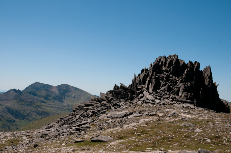
It’s a fascinating mountain – a lofty, rock-strewn plateau punctuated by jumbled clusters of spiky rock that form quite formidable turrets in places, such as Castell y Gwynt – the castle of the wind – and the slightly more pronounced summit of Glyder Fach. All make up the Glyderau massif, a classic mountain route in Eryri (Snowdonia).
Below is the full route description for this tricky mountain climb.
Hike the Glyderau: route guide
Start/finish: Idwal Cottage GR: SH649604 | Maps: OS Explorer OL17 (1:25k), OS Landranger 115 (1:50k) | Distance: 9.5km/6 miles | Ascent: 820m/2690ft | Duration: 5-6 hours | Transport: Buses from Bethesda and Capel Curig
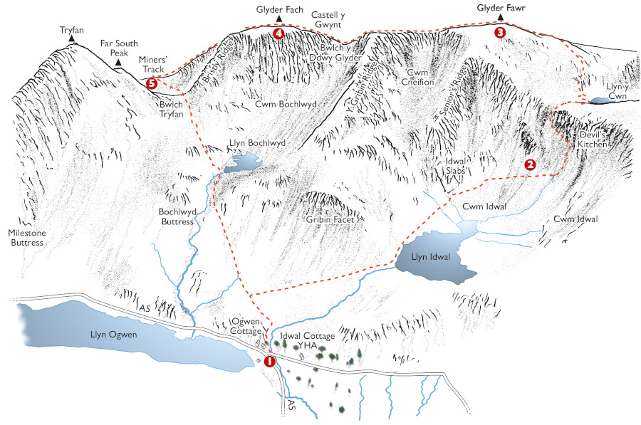
Illustration: Jeremy Ashcroft Maps
START/FINISH: Idwal Cottage
- GR: SH649604: Leave the car park by walking past the toilet block and take the well-surfaced Cwm Idwal path over the bridge and around a sharp right-hand bend to continue to Llyn Idwal. Here, break R, to keep the water to your L, and cross a beach before following a good path along the W shores of the lake. Continue beyond the water and ignore a path dropping L to climb steeply up into the head of the cwm.
- SH643589: Continue upwards, eventually ignoring another L turn to climb even more steeply through a narrow niche that leads onto easier ground close to Llyn y Cwn. At the lake, turn L to climb steeply through scree towards the summit of Glyder Fawr. The top is hidden in one of the many clusters of broken rock.
- SH642579: From the top, head E, first across a featureless plateau then dropping slightly into Bwlch y Ddwy-Glyder. Climb away from here and pass the impressive turrets of Castell y Gwynt – the castle of the wind – before continuing to the slightly more pronounced summit of Glyder Fach.
- SH656583: Leave the summit to the E again, passing the dramatic Cantilever Stone, and follow the escarpment edge. Care is definitely needed in poor visibility. You’ll start to drop quite steeply, passing the top of Bristly Ridge – a Grade 1 scramble. Keep ahead (E) and continue to descend steeply for another 1km; this is slow going so it may take longer than you’d expect. As the gradient starts to ease, keep your eyes open for a path that leads sharply L. If you reach the lake at Llyn Caseg-fraith, you’ve gone 200m too far.
- SH661588: Take this path, which cuts through the headwall of Cwm Tryfan, dropping to the valley floor and then climbing slightly again into Bwlch Tryfan. Cross the stile in the saddle and keep ahead to drop on a good path down to the shores of Llyn Bochlwyd. Keep the lake to your L and continue to the N tip of the lake, where a steep path drops alongside the outfall and then leads easily back into Cwm Idwal and the path you walked in on.
If you’d like to see other Eryri (Snowdonia) routes then check out our guide to the best here.


