
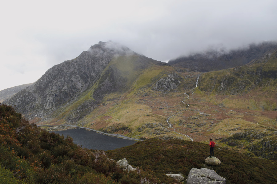
If you need your fix of Snowdonia ruggedness but want to bypass the crowds flocking to Tryfan, the Glyderau and Snowdon’s serrated Crib Goch ridge, the Carneddau range is a wise choice.
Below is the full route description for this tricky mountain climb of the Carneddau.
Hike the Carneddau: route guide
Start/finish: the westernmost parking layby off the A5 next to Llyn Ogwen; GR: SH656602 | Maps: OS Explorer OL17 (1:25k), OS Landranger 115 (1:50k), Harvey British Mountain Map Snowdonia North (1:40k) | Distance: 16.4km/10.2 miles | Ascent: 1356m/4449ft | Duration: 7 hours
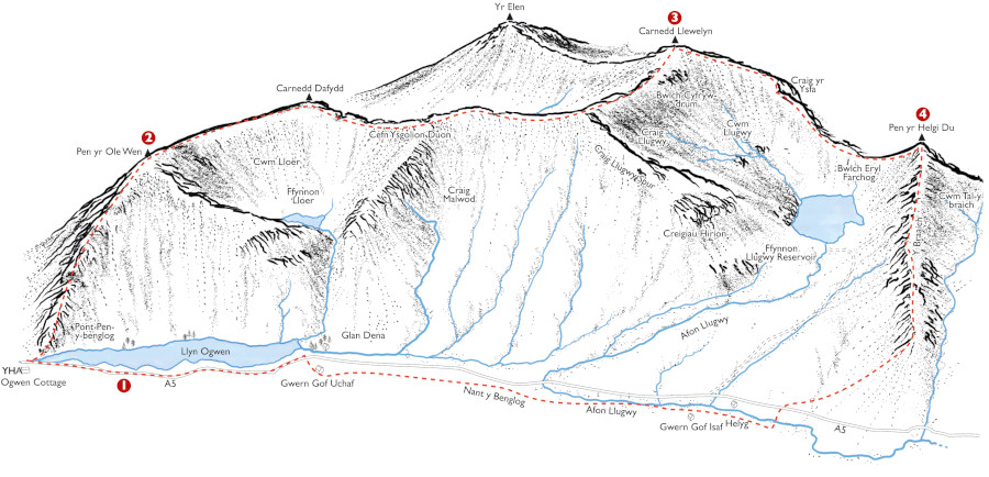
START/FINISH: the westernmost parking layby off the A5 next to Llyn Ogwen
- SH656602: Head W along the A5. Pass Ogwen Cottage and, after the road bears NW over a bridge, turn R at a fingerpost sign. Fork L and scramble NNE over rocky outcrops. Emerge onto a clear path with sections of stone pitching. The ascent ahead is steep with some easy scrambling. Cross a flat, boggy section on stepping stones before resuming the steep climb. Take the trod ahead over loose scree, aiming to the L of a huge crag. Continue ascending just E of N and scramble up a gully-like groove between jagged rocks, negotiating a few awkward rocky steps. Emerge to gentler terrain at the 750m contour line. Ascend to the R of the western cliffs, maintaining the same bearing. Pick a line over boulder fields, where the path is intermittent. Pass a wind shelter at 960m and veer R over grassier slopes to arrive at the summit.
- SH655619: Head NE to a cairn and pick up a clear path bearing N for the ridge. Descend briefly before climbing again over undulating terrain. Veer NE and climb over boulders to Carnedd Fach. Continue NE over rockier ground on an intermittent path. Pass two cairns close together and beyond to a prominent wind shelter, before emerging at the Carnedd Dafydd summit. Bear E following a series of cairns and descend gently to the R of the Ysgolion Duon cliffs. Veer away from the cliffs, aiming NE over boulder-strewn slopes for the narrow ridge to Bwlch Cyfryw-drum. A clear path guides the way over the crest of the undulating ridge, which merges into the bulk of the mountain. Continue to climb N, heading parallel to an old drystone wall, and arrive at a wind shelter. Turn L momentarily to the summit of Carnedd Llewelyn.
- SH683643: Head to the L of the wind shelter and descend SE to a large cairn. The steep, winding path bears E initially before turning SE again. At a path junction, turn left over higher ground to a cairned top. Descend gently SE and S. Beyond a final hump, negotiate a tricky section of rocky scrambling down towards the narrow spine of land at Bwlch Eryl Farchog. A clear trod heads SE over the ridge. At the end of the ridge, a cone-shaped climb lies ahead. The ascent requires a touch of easy scrambling but the best line is well-defined. Arrive at the grassy summit of Pen yr Helgi Du.
- SH698630: Descend S over rounded, gentle slopes. Pass to the L of a small tarn and continue easily down on a clear, grassy path. Go through a gap in a drystone wall and aim S for a footbridge over the weir channel.Go over a ladder stile, cross the bridge and turn R. Head SW on an intermittent trod, bearing to the R of a cluster of sheepfolds. Cross a ladder stile and descend SW, guided by two white-tipped marker posts. Reach a track and turn R. Beyond a cattle grid, cross the road and go over a ladder stile onto a path ahead. Cross a bridge and another ladder stile before turning R onto a lane. Go through a gate, bear R and walk through the campsite at Gwern Gof Isaf. Continue W on a wide track running parallel to the A5. Cross the footbridge over Nant Gwern y Gof and pass to the L of Gwern Gof Uchaf. Go through a series of gates and veer R to emerge at the road. Turn L along the pavement back to the car park.
If you’d like to see other Eryri (Snowdonia) routes besides the Carneddau then check out our guide to the best.


