
The Great Outdoors investigates what the future holds for map, compass, GPS and smartphone navigation
By Alex Roddie
For decades, map and compass have been the last word in getting up the hill and back down again. But ever more sophisticated digital tools are now available, and in 2018 we stand at a crossroadsne. What does the future hold for the way we navigate in the mountains and on the trail? As this profound change takes place, what do we stand to gain, and what do we stand to lose?
In our research, we contacted a range of users and brands to discover how people are using these tools in 2018 – and what the future holds.
The landscape right now
Our research indicates that, in early 2018, most hill-goers use both digital and traditional forms of navigation. While the map-and-compass combo is regarded as the safest, most reliable choice – and one everyone should know how to use – most people also use smartphone or GPS navigation for some tasks. For some users, the smartphone is just a last-resort backup, while for others it plays a far more active role, and the map is the backup system. Other users prefer to keep a dedicated GPS as their backup or supplementary system.
“Now that hardware is catching up with what the software can do, more people are gravitating towards using digital devices”
As part of our research, we conducted a Twitter poll with the question “Do you feel strongly about mapping on the hill – digital (phone/GPS) or paper + compass?”. 439 people voted.
- 10% said digital is better;
- 14% said paper and compass is better;
- 76% said that both have their place.
Despite this balanced picture, choice of nav tools remains a contentious subject and debate is energetic.
The case for map and compass
Proponents of traditional methods have many excellent arguments to back up their point of view. A topographical map and a baseplate compass have been crucial items for every hillwalker for decades, and there’s a lot to be said for the tried-and-true reliability of this combo. You know where you are with map and compass (literally).
We asked a number of hill-goers why they still prefer to use map and compass.
Emily Woodhouse
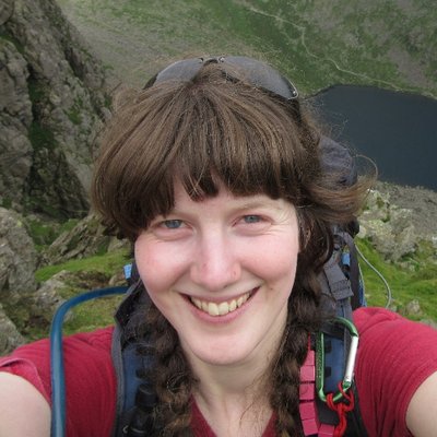 Emily is an outdoor writer and magazine editor, summer Mountain Leader, and Mountain Rescue team member.
“I have never used a smartphone on the hill (I don’t actually own one),” she says. “I’ve been on enough call outs to never trust a GPS location as certain. Signals from satellites can be blocked by mountains or bounce off them.
“I carry a map and compass every time I go into the hills. Most importantly, I know how to use them and take them out of my bag long before I need them! I’ve got to the level I’m at today through DofE, Ten Tors, the Mountain Leader award and many days (and nights) out practising.
“I think the biggest issue with GPS is the fallacy that ‘because the computer said it, it must be right’. It’s hard to go wrong with map and compass if you know how to use them. I’m more aware of my surroundings and more questioning of where I’m going.”
Ben Dolphin
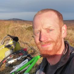 Ben is President of Ramblers Scotland, an outdoor writer and wildlife ranger, and an experienced hillwalker.
“I carry a map and compass, although the compass only comes out in bad visibility,” he says. “I have a very basic GPS. It’s been in my rucksack for 15 years in case of emergency, but I can’t recall ever having used it. I don’t think GPS is likely to improve or enrich my enjoyment of the hills.”
When asked why this was his favoured approach, Ben said, “Map and compass is how I learned. I like the tactile element, the sound and feel of the paper. I also enjoy the challenge and satisfaction of guiding myself rather than being guided by someone or something else.
“Safety concerns about choosing one method over another don’t really apply for me. I think concerns are manageable whatever means you use so long as you are aware of the limitations of your own method.”
Inaki Diaz de Etura
 Inaki is a lightweight backpacker who has completed many world-class long-distance trails, including the Pacific Crest Trail and Haute Route Pyrenees, and more esoteric trips in Newfoundland and Iceland.
Inaki favours a back-to-basics approach: “I follow the classic set of priorities: first, direct observation. If this is not enough, then map reading. When not yet enough, compass work, and if still in doubt, GPS (nowadays with digital mapping). Route finding is an innate human ability and it’s important to practise this skill, before even map use. Focus on the terrain first.”
“It’s not only about you can do, but about what you think you can do.”
Inaki is conscious of the less obvious drawbacks of GPS technology. “I’ve found that advanced digital navigation resolves issues so well and so quickly that it may make itself look more essential than it really is – as if you wouldn’t have fared well without it. This may kill your trust in more basic instruments or skills, leaving you helpless if the digital tool fails (even if you’re still carrying map and compass backups).
“It’s not only about you can do, but about what you think you can do,” Inaki adds.
The case for digital navigation tools
Persuasive as the arguments are in favour of map and compass, digital proponents are just as enthusiastic – and there are some compelling reasons to include digital tools in your navigation arsenal.
Alex Nail
 Alex is a professional mountain photographer, hillwalker, and TGO contributor. He’s out and about in both British and international mountain ranges in all weathers.
“I use my iPhone 6 loaded with ViewRanger almost exclusively for navigation,” Alex says. “I always have an external battery with me so the only realistic failure would be if the phone ceased to function. I carry a map and compass as a backup, and I occasionally practise to keep things fresh.
“Being able to position myself exactly is great. I also use ViewRanger as a planning aid. We are already at the point where smartphone navigation is better for most people most of the time. Maps are only better in fringe cases where reliability is totally essential, where power is an issue or where there is no backup. A compass is still far more accurate on heading than a phone though, so that would need to improve considerably before I left it behind.”
Oli Reed, ViewRanger
 Oli Reed is Communications Manager at ViewRanger, and spoke to us on behalf of the popular smartphone navigation app, which puts offline mapping and GPS tools on your handset.
“There’s been a perception shift in recent years. As the outdoor capabilities of apps, smartphones and smartwatches have increased, so has the sense of trust people place in them.
“The ViewRanger app is robust and offers a completely different experience to map-and-compass navigation. And now that hardware is catching up with what the software can do, more people are gravitating towards using digital devices.
“As someone who’s been hillwalking for a good few decades, I would never say there’s no place for printed maps. Technology is developing so quickly that it’s hard to say what we’ll all be using in a couple of years’ time, but at the moment I just see it as personal preference.
“Obviously printed maps will never run out of battery or smash on a rock, but you’ve only got to look at new devices like the rugged CASIO Pro Trek Smart watch and the incredibly exciting Land Rover Explore Outdoor phone that was unveiled at the ISPO show in Munich to see that digital navigation is constantly improving and evolving.”
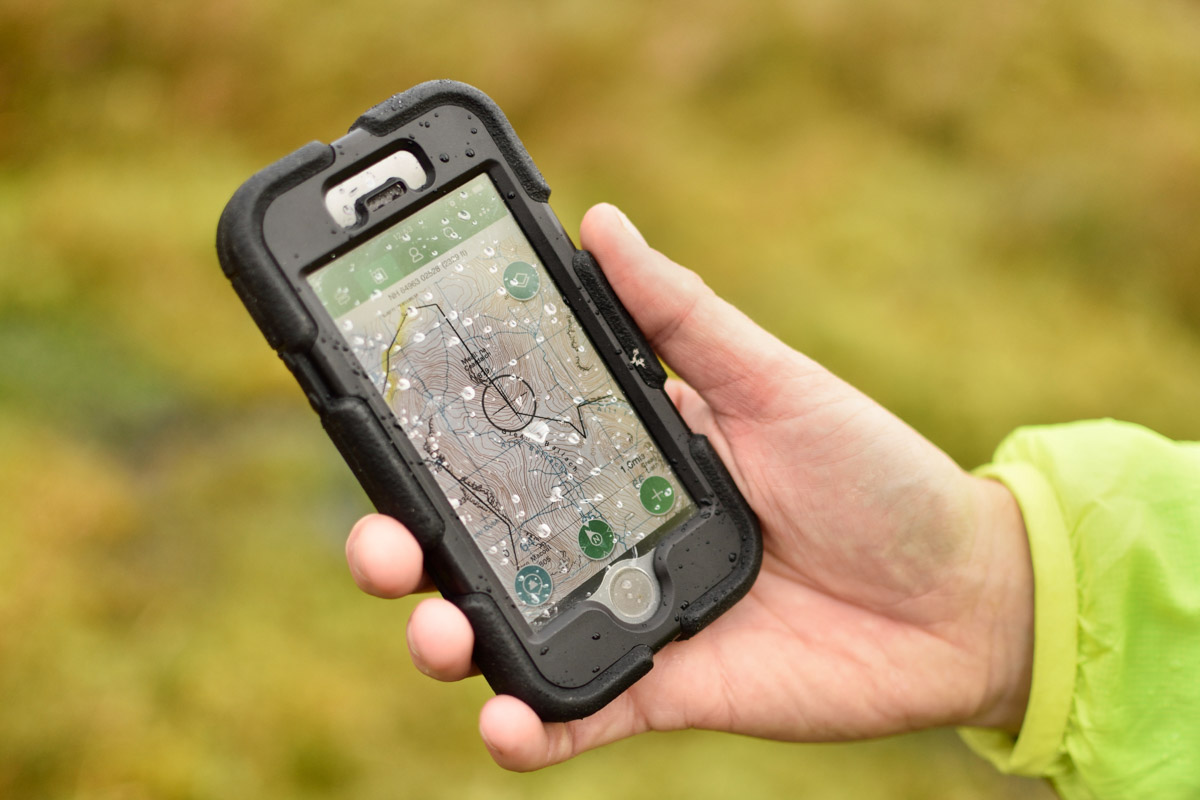
ViewRanger is one of the most popular and reliable mountain navigation apps (image © James Roddie)
Keith ‘Fozzie’ Foskett
 Another TGO contributor, Fozzie is perhaps best known for his long-distance trails in the USA, including the Pacific Crest Trail and Appalachian Trail. He’s the author of several books on long-distance hiking, and regularly goes backpacking in the UK.
“I use map and compass rarely,” Fozzie says, “although I practise occasionally to retain my knowledge. I do have a GPS but stopped using it because it wasn’t offering me anything that my smartphone couldn’t do.
“I use my smartphone 95% of the time, and store OS maps on my phone. Things changed for me in 2012 when I was thru-hiking the Appalachian Trail. The route was so well marked that most of us didn’t carry maps, just a smartphone app. On the Continental Divide Trail, with the need to pull in 20 or 30 miles every day, map and compass didn’t feature in my plans – however, I always carry a spare smartphone and a battery pack.
“I think we’ve already reached the point where digital is better: it’s more accurate, easier, and more readily available. Of course, it has drawbacks like battery dependence, and we need to hold on to map and compass – it’s a wonderful skill to have, and understanding these tools forms a closer connection with the landscape.”
The future
Three British brands leading the way towards the future of mountain navigation are ViewRanger, the Ordnance Survey, and Satmap. We’re grateful to the spokespeople from these brands for taking the time to illustrate how they are striving to create a future where safety, improved education and reliability go hand-in-hand with the convenience of digital tools. However, another important theme is emerging: nobody thinks it likely, or even desirable, that traditional tools will be completely replaced by new methods.
The Ordnance Survey
 The Ordnance Survey is the world’s longest-established mapping agency. In addition to their rich heritage in paper mapping, the OS is building a robust set of digital tools for both smartphones and dedicated GPS devices.
We spoke to Nick Giles, Director of Ordnance Survey Leisure.
“We provide the best of both worlds,” Nick said. “All of our paper maps come with a mobile download. This is a popular feature with our customers, as is our digital application OS Maps, which allows users to print accurate and to-scale mapping with routes overlaid.
“We work closely with Mountain Rescue to promote safety in outdoor environments.”
“We hear from people who use paper maps and compass as primary navigation, and use the app for quick position checks. Others tell us that they mainly use the app and keep paper map and compass as backup. The ability to download maps for offline use without a phone signal is also a popular feature.”
When we asked Nick about areas where technology hasn’t yet caught up with users’ demands, Nick said, “We always advise people to take a paper map too – our Landranger and Explorer maps are available in weatherproof Active Maps.
“OS’s focus is on how tech can be used appropriately and safely. Heavy usage can drain battery, which is something we’ve worked very hard on when developing OS Maps. As battery life improves, along with water and shock resistance, then smartphone navigation may become more viable.
“But if you value your safety (and Mountain Rescue’s) then traditional skills and paper may save your life.”
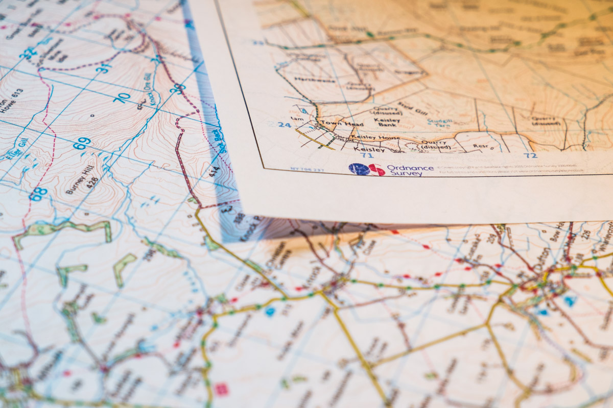
Print-on-demand mapping is a big innovation straddling the digital/analogue divide, and has many benefits over traditional shop-bought map sheets (image © Alex Roddie)
And how does the OS see the role of paper maps evolving? Nick was firm: “We see paper maps remaining core to safe outdoor activities, but there will be an increase in maps for specialist needs and bespoke areas. This will become easier with technological advances.
“Our paper maps are still very popular and sales have been consistent over the past four or five years, so it still has a role to play.”
What about education for digital users?
“Our GetOutside initiative has been running for several years and we have a range of how-to guides designed to encourage activity and promote safety. Our sixty OS GetOutside Champions are helping to support that safety message too, and we run regular navigation workshops at Cotswold stores nationwide. We also work closely with Mountain Rescue to promote safety in outdoor environments.”
What does the future hold for the Ordnance Survey?
“Recently we announced the launch of our new GPS devices, designed to be easy to use for the smartphone generation. We’ll continue to add features to the OS Maps mobile and web apps, including enhancements to Augmented Reality and 3D features.”
ViewRanger
 ViewRanger was the first practical smartphone app for mountain navigation, and today is one of the most popular solutions for serious users both in the UK and abroad. The app offers offline map downloads for many countries and a full-featured set of GPS tools.
Oli Reed, ViewRanger’s Communications Manager, spoke to us about the app.
“Our aim is to provide people with as many tools as possible to explore the outdoors safely,” Oli said. “For example, we introduced the augmented reality feature Skyline in 2016. Rather than replace the traditional map view, Skyline can be used for following routes and navigating, or purely for identifying peaks on the horizon – it’s down to personal choice.”
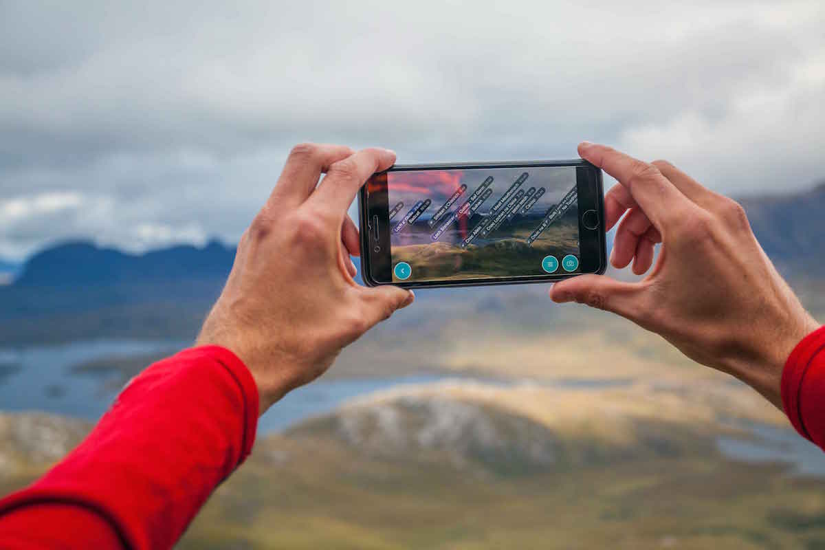
The Skyline Augmented Reality feature can give you a new perspective on mountain navigation – but it isn’t a replacement for existing techniques (image © ViewRanger)
ViewRanger take reliability and safety very seriously, but it’s reassuring to see that the team has a realistic view of what smartphones are capable of: “I have complete trust in the ViewRanger app, but as software developers we obviously can’t control the performance of the device you’re using,” Oli said.
“We’re committed to making sure ViewRanger is the best and most reliable mountain navigation app out there”
“It’s true that not all smartphones can be fully relied on in extreme weather and tough mountain conditions, but huge advances are being made. Battery life, durability, improved GPS capabilities and the ability to withstand water are so important. Although we can’t yet say that every phone is completely bombproof there could come a time when that’s close to becoming a reality.
“We work closely with Mountain Rescue and are proud to say that over 350 teams worldwide now use and trust the ViewRanger app. We receive constant feedback from Mountain Rescue and consult them regularly on new features, because the safety of ViewRanger users is of paramount concern to us.”
And how does ViewRanger help train and educate users of its app?
“We work closely with the Mountain Training Association to make sure anyone attending their Hill and Mountain Skills courses understands how to properly use the app, and smartphone navigation in general, when they’re on the hill.
“We’re constantly trying to educate our users on best practices when they’re in the mountains. We encourage everyone to download all of their maps for offline use so they aren’t reliant on phone signal. Our BuddyBeacon feature allows people to share their real-time location with friends, which is another tool regularly used to great effect by Mountain Rescue teams.
“I fully understand the concerns people still have with regard to smartphone navigation, which is why we always listen to feedback from our users, including thousands of mountain professionals.”
Image © ViewRanger
What about ViewRanger’s future plans?
“Let’s just say we’re committed to making sure ViewRanger is the best and most reliable mountain navigation app out there – and there will be plenty more announcements to come from us throughout the year. Watch this space…”
Satmap
 Satmap is a British brand specialising in rugged GPS handsets for mountain use in the most demanding scenarios. We spoke to Howard Dyson, Managing Director.
“Our Active 20 is packed with a host of advanced features: outstanding GPS reception, hi-res OS mapping on a bright screen, a super-robust case. But users need to be able to use them correctly. We always advocate a backup means of navigation for big trips. Reliability of these devices has increased hugely, but nonetheless things can go wrong.
“We advise a backup power source for long trips. Sadly, the power density of LiPol batteries hasn’t changed much in a number of years – but more manufacturers are offering power-saving measures, and GPS units are no exception.
“There’s a strong temptation to grab a smartphone app and go, but there’s a case for using a dedicated GPS device and preserving the smartphone as Plan B. Smartphones notoriously gobble battery life, and preserving emergency comms is vital.”
How is Satmap promoting safety through training or education, and what are your tips for safe mountain navigation?
“We work closely with the team at GPSTraining.co.uk as we believe that map-and-compass skills are a core element of safety on the hills. We support both online and classroom-based learning.
“Always start with a good paper map of the area, great for planning and as a backup. Learn some basics of how to read a topographic map, and know how to use your GPS. Ensure you have backup battery power and have a navigation Plan B. Have comms and comms backup, expect the unexpected, and enjoy!”
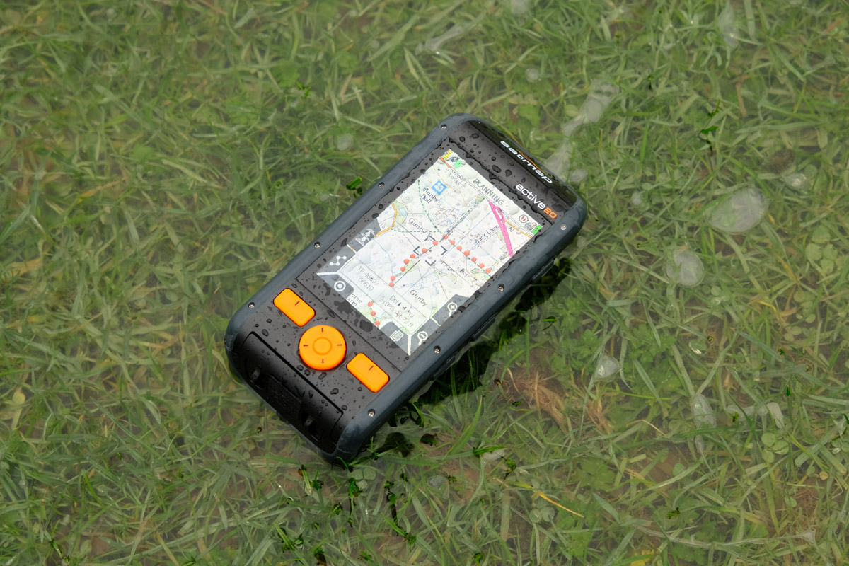
Satmap’s Active 20 handset combines a touch screen and OS mapping in a rugged, waterproof handset suitable for the very worst mountain weather
And how is Satmap developing and evolving as more users adopt digital or hybrid methods?
“Our recent focus has been on increased connectivity on our Active 20 handset. This includes linking the GPS to the internet via Wi-Fi, allowing greater search functionality, adding routes from the cloud, team tracking, and so on.
“Xpedition2 (our new planning web suite) will be a big step forward – allowing ease of route planning on any device, providing a host of national mapping and routing functions.”
Last words
The future of mountain navigation is not about the extinction of traditional methods we know and love: it’s about choice.
Users will be able to choose the appropriate tool for the job, and these tools will be safer, more reliable, and more convenient to use than ever before. This doesn’t just apply to smartphone apps and GPS handsets. Print-on-demand mapping is a major innovation in paper maps, allowing users to retain the advantages of real maps while tailoring them to their precise needs. The level of customisation possible will only increase in the future, catering for niche requirements and esoteric pursuits.
We’re also seeing augmented reality – pioneered by ViewRanger and quickly adopted by the OS – emerge as an interesting additional tool.
What about the people who put their lives on the line to rescue us when we get in trouble? Mountain Rescue’s position is simple: be competent.
Donald MacRae, Team Leader at Dundonnell Mountain Rescue Team, told us: “Digital navigation aids are certainly more readily used today. So long as users know how to use them then they have a place in your kit, but this should NOT fully replace paper map and compass and the knowledge of how to properly use them.”
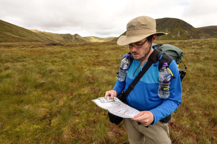
Header image © James Roddie. If you use disposable plastic water bottles on the hill, reuse and recycle them!


