
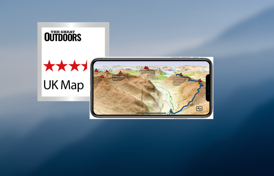
The main map screen on the UK Map App is clear and presents an uncluttered view of the map, with just a few buttons around the edge of the screen. Zooming in and out is fluid. Contour shading for hills is on by default (but can be turned off). I like how easy it is to get an OS grid ref – just tap a button and a cross-hair appears, showing the grid ref as you scroll around. You can also search for locations and this even works offline. A button lets you toggle between 2D and 3D mode.
- Platforms: iOS
- Price: base maps are free and good enough for most uses; OS mapping from £1.99 per region
- Maps: free 1:25k and 1:10k UK maps based on OS VectorMap with footpaths superimposed from OpenStreetMap; paid OS maps at 1:50k and 1:25k scale
- Features: route planning, OS grid ref, track recording, GPS import/export, 3D route preview
- Offline?: yes, all functionality except downloading maps
- ukmapapp.com
Beyond the map screen, the interface feels confusing and cramped due to the custom interface that doesn’t look at home on an iPhone. Unusually, the downloadable free mapping is based on OS data and is of excellent quality – almost as good as ‘real’ OS maps, complete with contours, footpaths and crags/rocks. Traditional OS 1:50k and 1:25k maps are also available. These are affordable on a regional scale (for example, Cumbria at 50k is only £2.99) but expensive if you need the whole UK. There is no subscription option.
GPX file management is mostly very good. You can import and export GPX files offline, view elevation graphs and distances along the route, and display multiple tracks and waypoints on the map. They can also be colour-coded, and you can choose from different icons for the waypoints. Route planning, however, is rudimentary with no snap-to-path.
I like the fact that this is an old-school navigation app, focused on offline functionality and GPX file management with no social or online features whatsoever. However, there are times when it feels just a bit too old-school. If you can get past the somewhat confusing interface, don’t need maps for the entire UK, and prefer an old-school app with a focus on data and GPX files,
this could be a good option for you.


