Popular outdoor navigation app ViewRanger launches £3.99 yearly bundle offering augmented reality, 3D flyovers, unlimited offline mapping, and more.
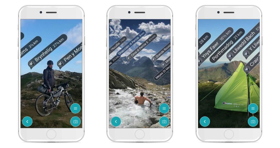
ViewRanger has long been one of the best apps for outdoor navigation. In recent years it has added features such as Skyline (an augmented-reality feature using your phone’s camera to identify nearby peaks and waymarks), smartwatch support, and more.
ViewRanger’s new Premium subscription bundles four features in a £3.99 yearly payment:
- Skyline: “Use your camera to identify peaks, places, and other points with augmented reality. See direction arrows and waypoints when following a route too.”
- 3D Flyovers: “See tracks and routes in amazing 3D. Replay your recorded tracks. Pan and zoom around your own pre-planned routes and route guides shared by other publishers.”
- BuddyBeacon: “Bring safety to every outing. Privately share your real-time location with friends and family.”
- Unlimited offline maps
This service differs from the previous ViewRanger Premium map subscription in that unlimited offline Ordnance Survey maps are not offered on the £3.99 tier; this still requires the existing £24.99 yearly subscription, now called Premium+. However, all Premium+ subscriptions also include all Premium features as standard.
SkyLine and BuddyBeacon were previously free features. However, Kris Wagner, Marketing Director at ViewRanger, told The Great Outdoors that more features for Premium subscribers are on their way. Our view is that £3.99 is a small price to pay for such useful additions to the core ViewRanger experience.
viewranger.com/premium