
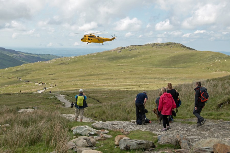
what3words is being hailed by emergency services across the UK, but Mountain Rescue is ‘wary’ of reliance on such technology – and there are questions regarding the sustainability of its business model.
Updated 27 September 2019 with response from what3words.
what3words is an app that allows anywhere in the world to be described by a combination of three unique words, precise to 3m x 3m – effectively, a more user-friendly version of grid coordinates, or the universal latitude and longitude system.
Some emergency services in the UK have encouraged individuals to download it to help with emergency responses. The Thames Valley Air Ambulance and UK Coastguard are among organisations listed on the app’s website as users of the technology, and the BBC reported last month that some 999 call-handlers are advising people in trouble to download the app.
The Great Outdoors contributor and tech expert Alex Roddie has tried the app, and said this about it: “The app is simple to use and does not require phone signal for basic functionality, although it does rely on GPS. On launch, the app gives you a three-word reference – for example, marble.messaging.hacksaw for the summit of Ben Nevis – and you can also zoom, pan and tap on the app to find the reference for any other grid square.
“The map view is powered by Google Maps and needs an internet connection to show anything. You can toggle between standard Google Maps view (not very useful for the outdoors) or satellite view (slightly more useful). There is no ability to use any form of topographic map.
“There’s also an extremely basic ‘navigate here’ function, which lets you ‘navigate’ to a square either using a rudimentary compass screen or a mapping application such as Google or Apple Maps. At the time of writing, it cannot be used with popular outdoor apps such as ViewRanger or OS Maps. This makes the navigation function almost useless on the hill.
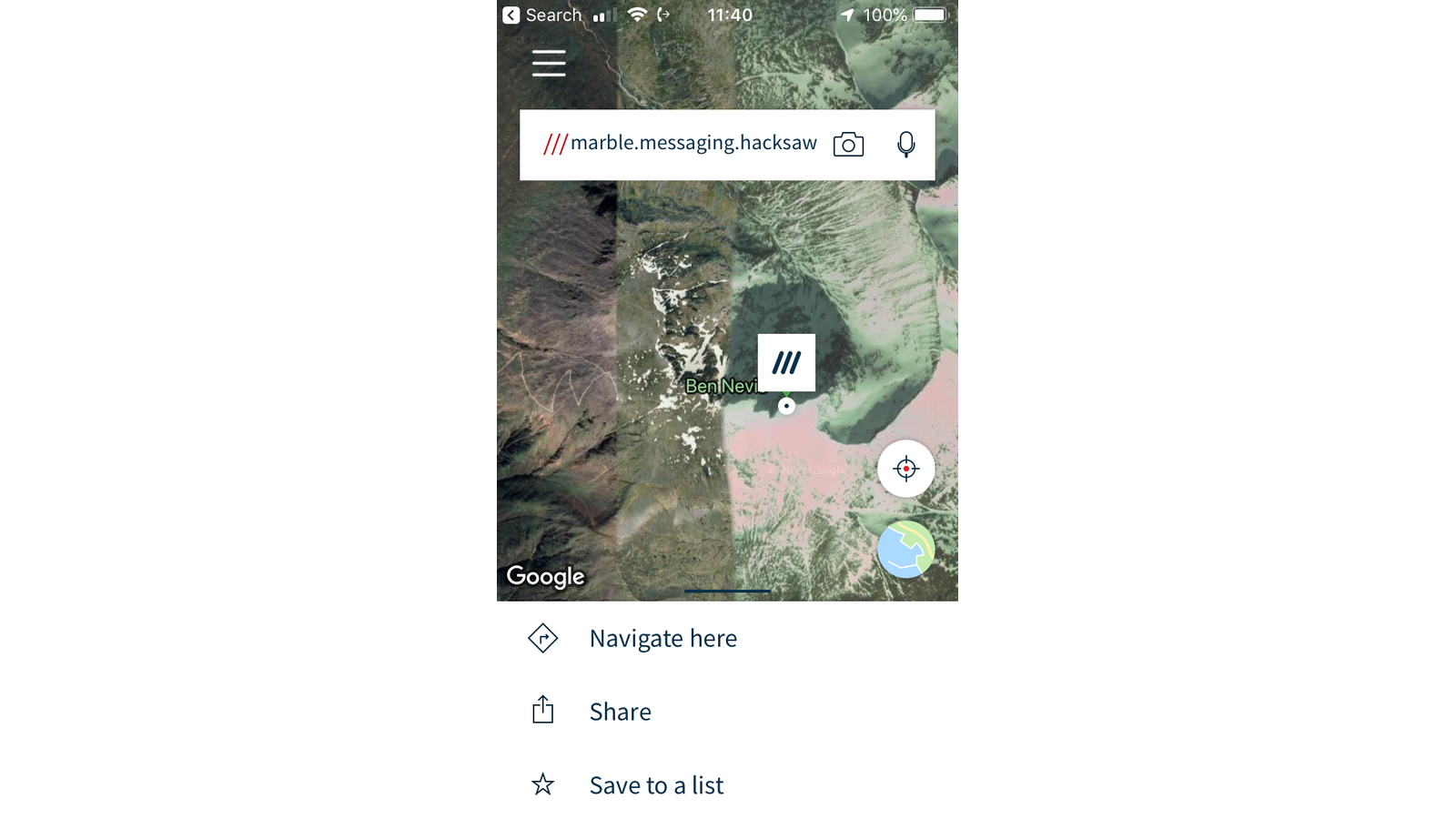
The main screen
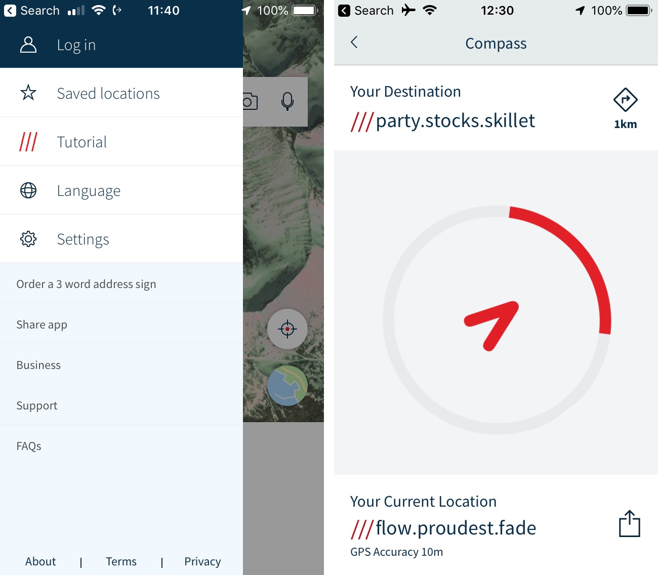
Left: main menu, including a link to ‘order a 3 word address sign’
Right: an extremely basic navigation screen, unsuitable for anything but the most basic mountain use
“The app is worth having on your phone in case of emergency, but it is not a replacement for being able to provide a grid reference if things go wrong – and it is certainly not a replacement for the ability to read a map and navigate using established techniques.”
False sense of security
Mountain Rescue England and Wales (MREW) welcomed the app but cautioned against technology creating a false sense of security. Mike Margeson, Vice Chairman and Operations Lead, said:
“In an emergency situation, mobile phones are very useful but people need to use them first and foremost to raise the alarm and to keep in touch with rescue services. We’d encourage everyone to register for the Text 999 service to make that first contact as easy as possible.
“Apps like what3words and OS Locate are a great help in pinpointing a location but they also use up precious battery power so, while we welcome anything that could contribute to safety, we’re wary of adding to people’s reliance on their mobile phones.
“MREW is keen to encourage those planning a day in the outdoors to carry a paper map and a compass, to know how to use them and also to carry a torch so that these tools can be used if it gets dark.”
A potential problem
An aggressive marketing push on social media has seen interest in the app explode over the past few weeks, although some professional mountaineering instructors are wary that emergency services and businesses are already at risk of placing too much reliance on a free app that could disappear – or radically change its business model – at any time.
The Great Outdoors contacted Rebecca Coles, winter mountaineering and climbing instructor at All But Essential Travel, who said that she could see its uses but was wary of anything that further increased reliance on smartphones in the hills:
“It may be especially useful in countries without good mapping. In these cases using latitude and longitude is laborious, and the long string of numbers open to errors and miscommunication. I can also see what3words having potential in urban areas when an address or street name are unknown.
“However, in the UK the British Grid system is very effective and the hillwalking community is widely knowledgeable of it.
“Being able to read a map and give a grid reference is still a core skill for going out in the hills. I’d always encourage people to not only give a grid reference but also a description, like the name of the crag or hill, to enable a cross-check location. The OS Locate app can help as tool for double checking a grid reference but, like what3words, is beset with the limitations of relying on smartphones in the hills.”
Outdoor instructor Richard Prideaux of Original Outdoors, who has extensive experience as a search manager in Mountain Rescue and now trains Search And Rescue teams and emergency services, is concerned that the app is being adopted with little scrutiny. He is also worried that what3words is built on a closed, commercial infrastructure – bad news for something positioned as an essential safety tool.
“It is undoubtedly a slick, well-managed and intriguing tool that has created a unique position format system that somebody who is scared off by grid references and lat/long can use easily,” he told The Great Outdoors. “The tool itself doesn’t concern me, and I have occasionally used it to direct people to gateways or meeting points when ‘dropped pins’ on other mapping apps or OS grid reference became lost in translation. It seems to work, although it doesn’t replace something that existed before – it just repackaged it.
“What concerns me is the aggressive marketing of the app and the media response to it. Tools for locating missing persons and casualties using their smartphones have existed for many years, and one of the best (SARLOC) was open-source, offered to UK MRTs for free and has saved many lives. It requires minimal effort from the casualty, and if it suddenly disappears from existence it can be recreated overnight with some simple coding.
“Organisations that have been happily locating and retrieving people from remote locations all over the UK are suddenly being asked to comment on a commercial app, with demands to know how and why they are using it in their command and control systems.
“what3Words does not replace any navigation tools, does not help somebody find their way across a landscape and is built on a closed infrastructure that relies on commercial licensing to keep itself running.
“When it’s used as a tool for individuals to share locations between smartphones then it’s one of the best of a flotilla of apps that do the same thing. When emergency services and businesses are urging each other, driven by a clever marketing campaign and social media influencers, to tie this application into their safety plans and infrastructure then we have a potential problem.”
A robust product
We contacted what3words for comment. Giles Rhys Jones, CMO of what3words, gave us this statement:
“what3words is a simple way to communicating location. This can be useful when existing methods may not be known, or not preferable or practical – for example, giving a string of coordinates over the phone in an emergency situation, a landmark based description or a postcode. We by no means see ourselves as a replacement for learnt navigation skills, traditional addresses themselves and we echo the need for people to be prepared when venturing out.
“We are being used across the UK by rural emergency services – from Search & Rescue through to Air Ambulance teams – to great effect. They are encouraging people who might be in poorly addressed locations to download the app because it helps them attend the scene faster – and in an emergency situation, every minute is critical.
“We’ve heard many stories over the past year where what3words has helped to recover victims and save lives. Plenty of the stories have been covered in the press.
“We are also used for various humanitarian projects and in disaster relief and rescue operations around the world. These include the UN, the Red Cross in the Philippines, the Mexican Government and Traveller Assist.
“Our app is free and we are not charging emergency services for use of our technology.
“We licence our code to amount others, automotive, delivery and navigation business including Mercedes-Benz, Tata motors and DB Shenker. Operating as a business enables us to continually develop a robust product by adding more features, more languages and it allows us to offer the service free for individuals, small businesses and humanitarian organizations.
“what3words has also been integrated into navigation apps like Navmii, Pocket Earth and ViewRanger.”
Header image: Shutterstock / Alan M Barr


