Home/Long Reads/What Lies Beneath: photographing Scotland’s mountains from above
What Lies Beneath: photographing Scotland’s mountains from above
Documentary photographer Richard Cross rises above the shortbread tin romanticism colouring our outdoor heritage with a novel perspective on Scotland's mountains as applied to the land use issues of our day.
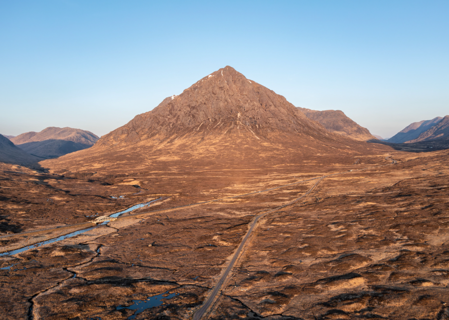
Main image: Buachaille Etive Mòr is one of Scotland’s mountain icons | Credit: Richard Cross
There’s a myth that clings to the Scottish Highlands and Scotland’s mountains — of vast, untamed wilderness, untouched by human hand. It’s a powerful story, rooted in romanticism and reinforced by tourism campaigns, films, and even maps that designated areas as “wild land.” But once you spend time here – walking, looking, seeing – that illusion begins to unravel. The truth is more complex, caveated and potentially even more hopeful.
The iconic Buachaille Etive Mòr (Great Herdsman of Etive) stands as a sentinel on the edge of Rannoch Moor, its pyramidal form instantly recognisable. From above, the road across the moor blends into the background, hardly more visible than the deer trails that crisscross the ground below. In a postcard view of the landscape, human intervention can seem diminished, while the deer (whose trails are largely invisible from ground level) leave shape the vegetation in ways we’ve stopped noticing, their impact hidden in plain sight.
I moved to Scotland with a background in documentary photography and a love of the outdoors. At first, I saw the Highlands like many others do – open spaces and dramatic views that seemed to confirm the myth of wilderness. But over time, my perspective shifted. That change didn’t happen overnight. It’s been a slow, evolving process, shaped by more than 30 years of walking, reading, and reflecting on what I’ve seen. And once you learn to see the landscape differently, it’s impossible to unsee.
As above, so below
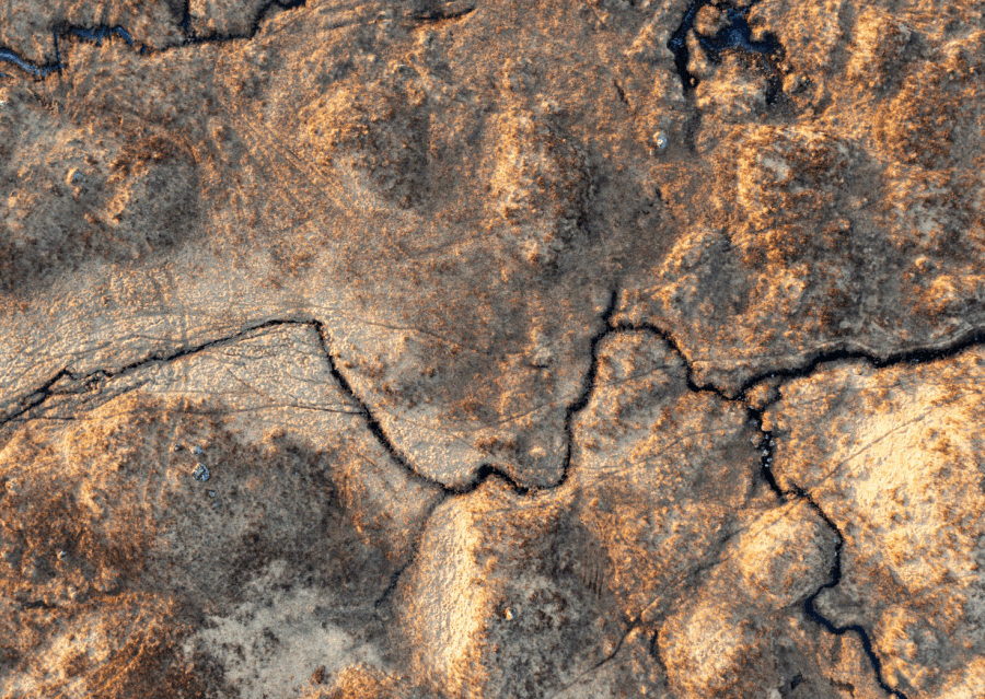
What Lies Beneath is an ongoing photography project that pairs more traditional landscapes with aerial images taken directly overhead. Shot over the last six years, it attempts to reframe familiar terrain and reveal the marks of human presence often overlooked: animal and vehicle tracks, drainage channels scars from burning, and the outlines of abandoned enclosures.
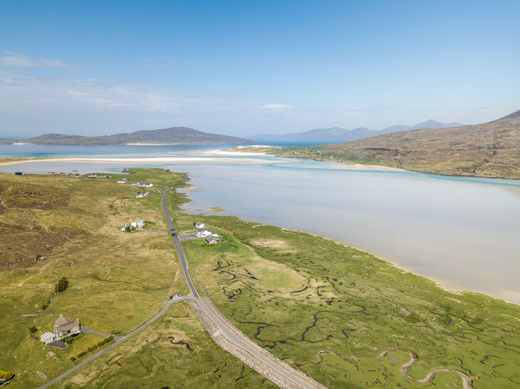
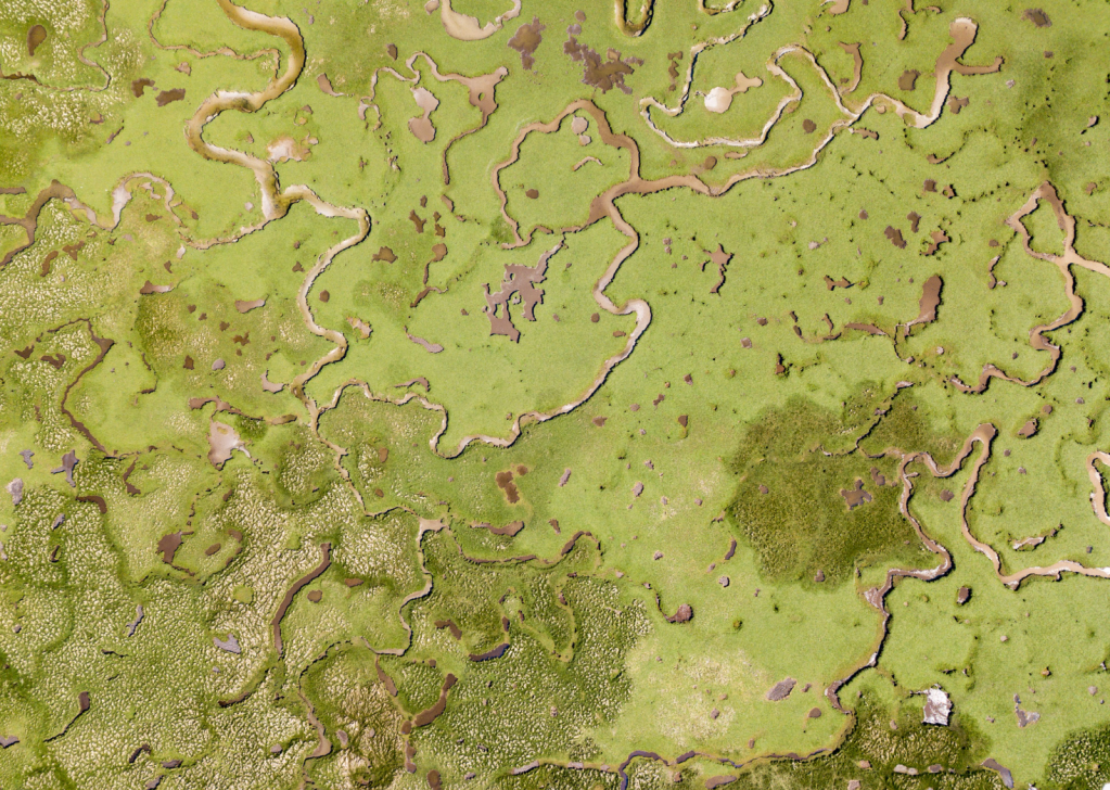
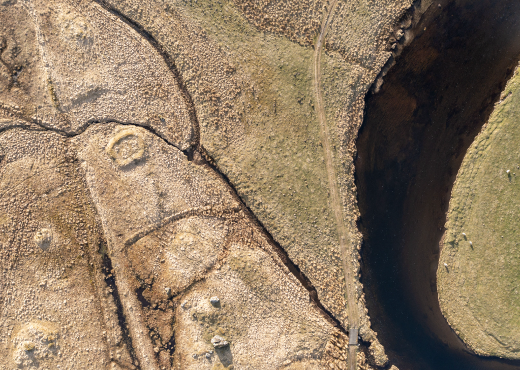
The machair near Luskentyre on the Isle of Harris showcases a rare coastal habitat where fertile grasslands meet expansive beaches, a unique ecosystem supporting wildflowers, birds, and insects. Historically, traditional low–intensity grazing and crofting practices maintained this balance. However, like many fragile ecosystems, it faces threats from climate change, rising sea levels, and changing land use practices. The intricate patterns visible from above hint at both the resilience and vulnerability of this ancient landscape.
These aren’t manipulated images. They simply show what’s there. They challenge the idea of wilderness by revealing what lies beneath, both literally and metaphorically.
Often, the paired images also show historic changes over time — transitions, tensions, and contradictions. Sometimes they reveal nature’s resilience; in others, they capture its degradation. The visual contrast between ground and aerial views can highlight these changes. But while change is constant, it isn’t always progress.
Walk through any glen or over any hill and you’ll find the signs of management are everywhere. Deer fences line the hills. Bulldozed tracks provide access for field sport. Forest plantations grow in geometric blocks, while remnants of native woodland survive only on steep, inaccessible slopes.
Some landscapes are overtly constructed – grouse moors, plantations, hydro schemes. Others speak more quietly: in depleted vegetation, drained bogs, or the absence of wildlife we’ve forgotten should be there. These absences matter. And from the air, they’re harder to ignore.
A key moment in the change of my understanding of the landscape was reading about the idea of shifting baselines – how each generation accepts a more depleted version of nature as normal. What once would have been seen as barren now passes for pristine.
Photography has helped me see these anomalies – and challenge them.
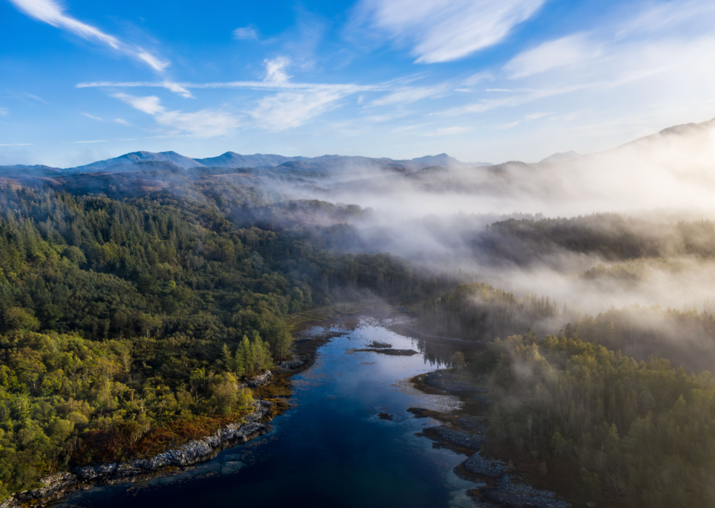
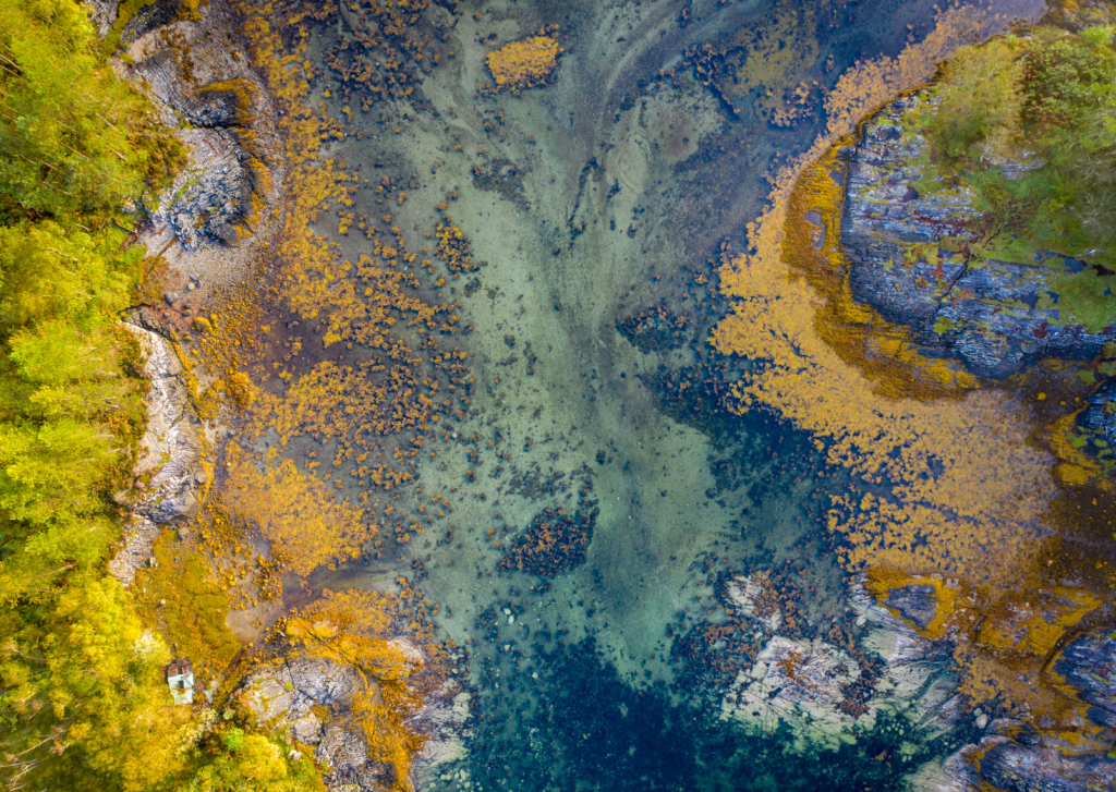
Sàilean nan Cuileag on Loch Sunart, translated from Gaelic as the Bay of Flies, has long served as a natural harbour. Once used to export goods such as charcoal, oak bark, and brushwood – and said to have sheltered Viking boats through the winter months – its shoreline has seen centuries of human activity. Yet over time, these traces have been eroded by wind and water. Seen from above, the tidal shallows reveal a mosaic of kelp and bedrock, its colours and textures not obvious from the ground.
New point of view
The drone, especially, offers a broader, more detached perspective. It reveals patterns, textures, and interventions that aren’t visible from the path. But this project isn’t a critique. It’s about seeing the changes.
Across Scotland, rewilding and restoration efforts are gaining ground. I’ve seen native trees returning, peatland re-wetted, and biodiversity beginning to recover. These changes may be slow and localised, and they’re often more visible from above. When grazing is reduced, the land responds.
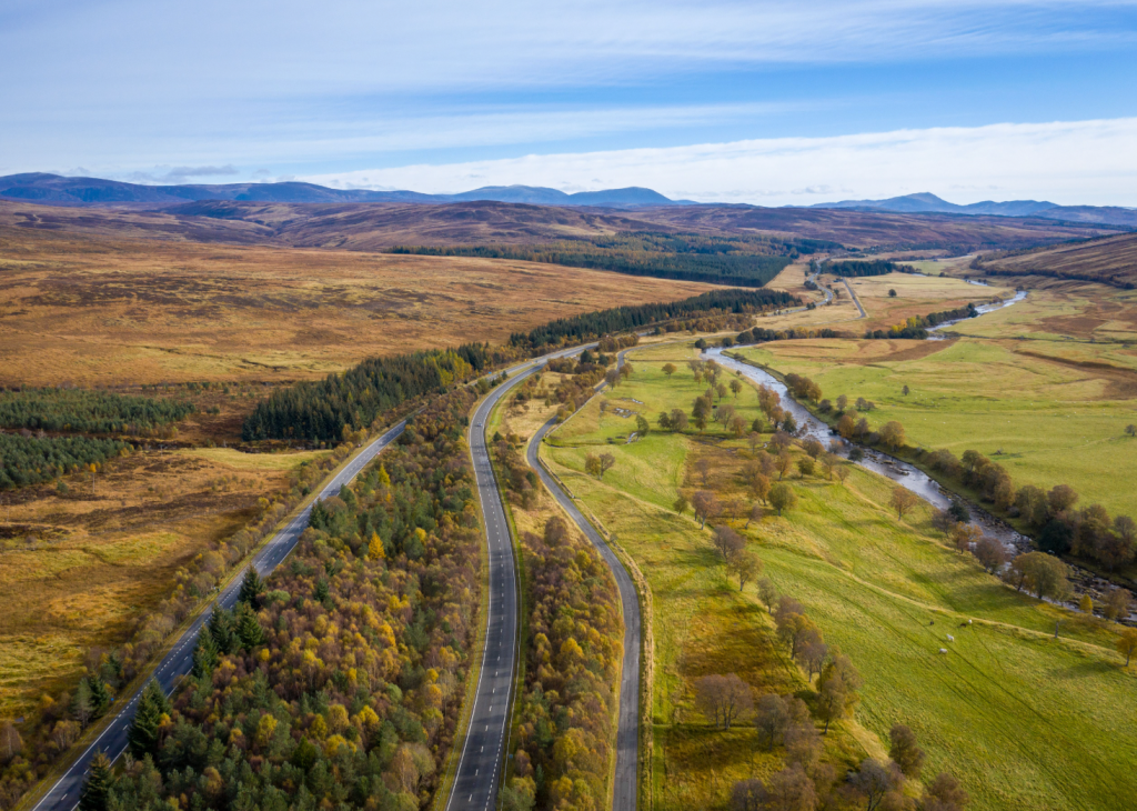
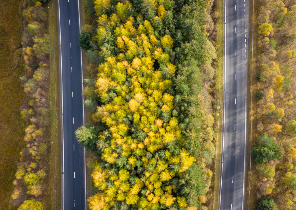
The A9 cuts a line through the Highland landscape – a corridor of movement carved through moorland and pasture. On either side, grazed fields and open hills show the long reach of farming and the hand of estates managed for sport. But the narrow strip between the carriageways is protected from grazing, and over time trees have taken hold, revealing how quickly nature reasserts itself when grazing pressure is removed.
Photography helps me see these transitions. It slows me down and encourages me to revisit the same places with fresh eyes. For me, the drone doesn’t diminish the outdoor experience – it deepens it. I carry it with the usual hill gear and only bring the drone out when conditions allow and when no one is around. I’m careful not to fly near other people, mindful of how respect for the land includes respect for how others experience it too.
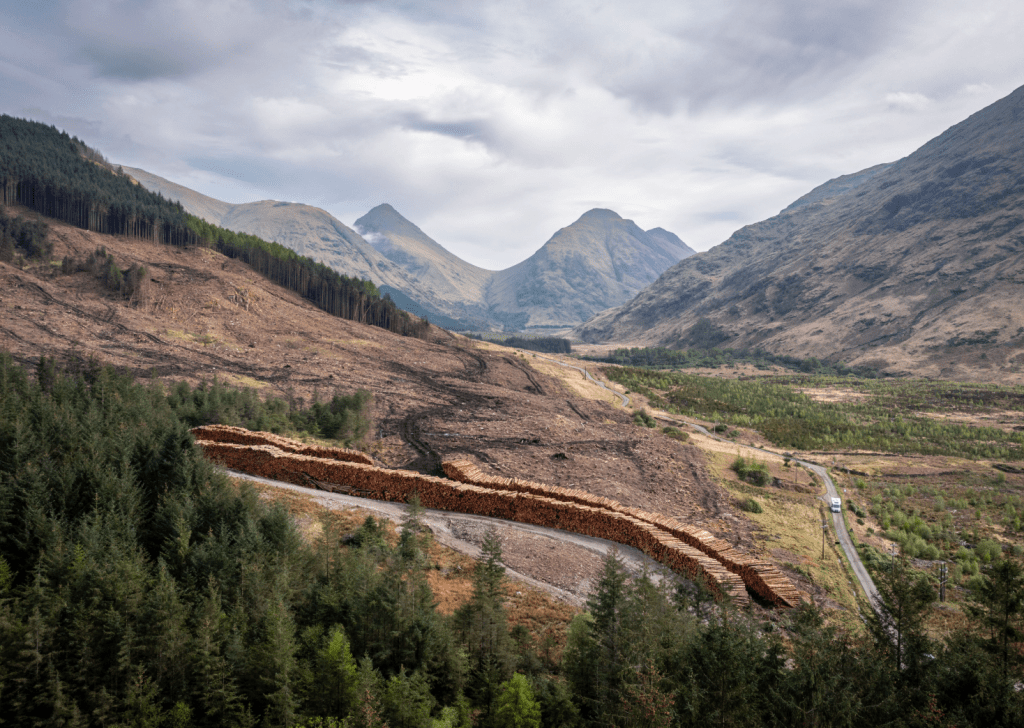
Most of the images here were unearthed while out walking, not pre-planned. I’ve learnt to keep an open mind. I visit a place with a fixed idea of what I’ll find, I often have my expectations confounded. In Glen Etive, for instance, I expected the run-of-river hydro schemes to dominate the view. But from above, they blend into the landscape far more than I’d anticipated.
What struck me instead was the scale of the felling of the surrounding plantations, great patches of bare hillside, raw and exposed. Both are legitimate uses of land – we need energy and timber. But the perceived impact varies depending on our perspective, and it rarely matches our assumptions. It’s complicated.
The aftermath of clear-felling exposes the scale of industrial forestry in Glen Etive. Vast tracts of plantation have been harvested, leaving behind a stark, scarred hillside and long stacks of timber. While run-of-river hydro schemes in this area have blended more discreetly into the land, tree felling leaves an unmistakable visual and ecological impact. Glen Etive is a designated National Scenic Area, yet economic land use and environmental values visibly collide.
Seeing Scotland’s mountains anew
Seeing degraded landscapes in areas designated as “wild,” including our National Parks, creates a dissonance. But it’s also revealing. If we’re going to talk honestly about land use and restoration, we need to move beyond the wilderness fantasy. We need to ask hard questions: Who owns this land? Who benefits? What does meaningful regeneration look like? Can our celebrated rights of access survive land reform and ecological repair?
There’s power in seeing the land clearly – not just as a backdrop for recreation or a resource to be extracted, but as a living system, shaped by people, policy, and history. And still capable of healing. That healing won’t come from nostalgia. It will come from listening – to ecologists, to historians, to local communities, and to the land itself.
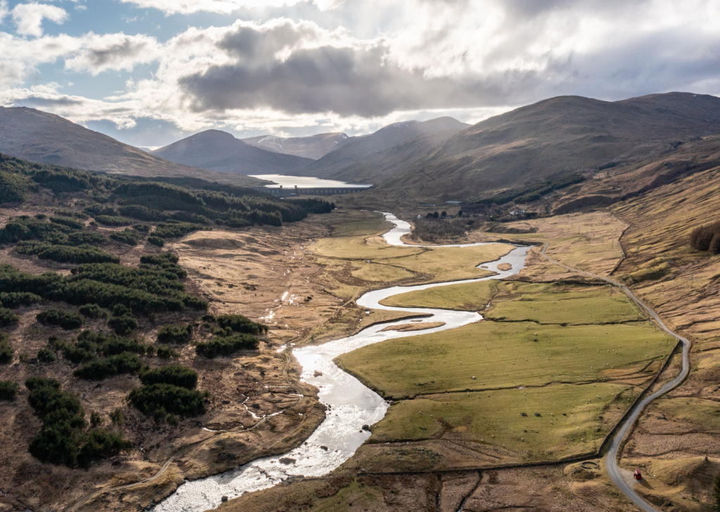
A dammed river, plantations, sheep pasture, bare hillsides – it could be almost any Scottish glen. But beneath this familiar landscape lie hidden stories. The remains of abandoned buildings hint at lost settlements, while close to this spot is a memorial cairn for Robert Campbell (1808–1894), a native of the glen and a notable explorer of the Arctic regions of Canada. His life spanned a time when sweeping changes forced many to seek opportunity far beyond their home – a pattern that continues today, as economic pressures and limited prospects still drive people from the land.
What Lies Beneath doesn’t offer answers. I hope it offers perspective — a different view of places we think we know. A reminder that what we call “natural” is often anything but. And that if we’re serious about restoring and protecting the places we love, we need to see them clearly — and completely.
The Highlands aren’t just a landscape. They’re a document — layers of memory, use, and meaning. And what lies beneath Scotland’s mountains is not only the past. It’s the future too.
The Great Outdoors
About
The Great Outdoors is Britain’s original mountain magazine. We've been helping people explore from sea to summit, valley to mountaintop for more than 40 years. Through compelling, long form storytelling and eye-catching photography, we seek to convey the thrill of adventure, the joy of exploration and the wonder of the natural world. The Great Outdoors exists to help you make the most of your time outdoors.
Father's Day Special OfferFree gift!
Gift The Great Outdoors this Father's Day and save up to 31%!