

Zahra Al-Kateb enjoys a varied section of the Thames Path
The historic Windsor Castle provided a distant backdrop – a reminder that you are walking along a Royal river – and I marvelled at the Runnymede memorials, including the Magna Carta temple of 1957, designed by Sir Edward Maufe for the American Bar Association, as well as the John F. Kennedy memorial of 1965, by Geoffrey Jellicoe. At Shepperton Lock, which marked the end of my walk, I found a small refreshment hut – perfect timing for a snack and a chance to reflect on the day I had enjoyed.
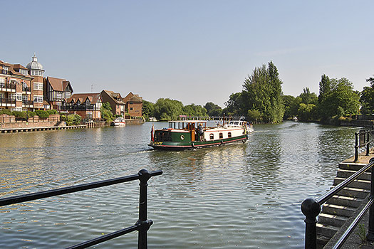
The Thames Path is an easy walk yet still manages to offer a remarkable amount of variety with many different aspects to explore, and can take you from the busy waterside by a small town to total tranquillity. The 184-mile Thames Path National Trail, from the source of the river in the Cotswolds to the Thames Barrier, is easily split up into sections that are accessible by public transport. For my walk, I chose to start at Windsor and amble down to Shepperton.
ROUTE DESCRIPTION
- From Windsor & Eton Riverside Station, walk down to Windsor Bridge, and take the steps down to the riverside promenade. Walk past the Slater’s Office until you reach a spit of land called The Cobbler.
- Pass through the kissing gate into the open fields. Walk along until you reach Black Potts Railway Bridge and can see Victoria Bridge. Bear R on the grass to a point where the white railings of the bridge approach the end of the road. Once over the river, go down the steps and follow the path until it leads away from the river and back to the road.
- Once you have reached Datchet, continue to follow the riverside until you reach a footbridge. Once over it, walk under Albert Bridge, up the slope to cross the bridge and turn down the steps to rejoin the path. A display panel by a car park will locate the entrance to the Runnymede memorials. Both are within easy access of the Thames Path.
- As the river begins to curve L, go through a gate and follow it. The path is now heading towards Staines. Go past Bellweir Lock and carry on under the double motorway bridge. Walk beside Staines Bridge to join the Thames and turn under Staines Bridge to walk down the stream again. Cross the River Colne where you will reach a small garden with fountains.
- Continue through the gates along the riverfront of the Thames Lodge Hotel. From Staines Railway Bridge, the path continues past riverside houses. Continue walking until you reach an open grass area where a broad track will lead to Penton Hook Lock.
- In another 800m, a turning up Blacksmiths’ Lane will lead directly to Laleham Church. Past the bridge is Chertsey Lock from where the path continues to Chertsey Bridge. Head under the bridge and through a kissing gate. Follow the riverbank to open meadows.
- Once you join the riverside road you will eventually find yourself looking across the Thames to Shepperton Weir. For Shepperton Station, turn up the Ferry Lane, turn R at the top and follow the road for 800m. At the war memorial roundabout, carry on up the High Street, at the traffic lights the station is on the R.
Zahra Al-Kateb enjoys a varied section of the Thames Path
The historic Windsor Castle provided a distant backdrop – a reminder that you are walking along a Royal river – and I marvelled at the Runnymede memorials, including the Magna Carta temple of 1957, designed by Sir Edward Maufe for the American Bar Association, as well as the John F. Kennedy memorial of 1965, by Geoffrey Jellicoe. At Shepperton Lock, which marked the end of my walk, I found a small refreshment hut – perfect timing for a snack and a chance to reflect on the day I had enjoyed.
The Thames Path is an easy walk yet still manages to offer a remarkable amount of variety with many different aspects to explore, and can take you from the busy waterside by a small town to total tranquillity. The 184-mile Thames Path National Trail, from the source of the river in the Cotswolds to the Thames Barrier, is easily split up into sections that are accessible by public transport. For my walk, I chose to start at Windsor and amble down to Shepperton.
ROUTE DESCRIPTION
- From Windsor & Eton Riverside Station, walk down to Windsor Bridge, and take the steps down to the riverside promenade. Walk past the Slater’s Office until you reach a spit of land called The Cobbler.
- Pass through the kissing gate into the open fields. Walk along until you reach Black Potts Railway Bridge and can see Victoria Bridge. Bear R on the grass to a point where the white railings of the bridge approach the end of the road. Once over the river, go down the steps and follow the path until it leads away from the river and back to the road.
- Once you have reached Datchet, continue to follow the riverside until you reach a footbridge. Once over it, walk under Albert Bridge, up the slope to cross the bridge and turn down the steps to rejoin the path. A display panel by a car park will locate the entrance to the Runnymede memorials. Both are within easy access of the Thames Path.
- As the river begins to curve L, go through a gate and follow it. The path is now heading towards Staines. Go past Bellweir Lock and carry on under the double motorway bridge. Walk beside Staines Bridge to join the Thames and turn under Staines Bridge to walk down the stream again. Cross the River Colne where you will reach a small garden with fountains.
- Continue through the gates along the riverfront of the Thames Lodge Hotel. From Staines Railway Bridge, the path continues past riverside houses. Continue walking until you reach an open grass area where a broad track will lead to Penton Hook Lock.
- In another 800m, a turning up Blacksmiths’ Lane will lead directly to Laleham Church. Past the bridge is Chertsey Lock from where the path continues to Chertsey Bridge. Head under the bridge and through a kissing gate. Follow the riverbank to open meadows.
- Once you join the riverside road you will eventually find yourself looking across the Thames to Shepperton Weir. For Shepperton Station, turn up the Ferry Lane, turn R at the top and follow the road for 800m. At the war memorial roundabout, carry on up the High Street, at the traffic lights the station is on the R.


