
Human and natural history dominate a beautiful walk across Downland near Arundel
I had imagined writing up this walk would be all about castles and churches, battles and sieges – and indeed there’s a very rich history in the area around Arundel, but it was the astonishing range of birdlife that lingered longest in my mind.
It was a cold, clear February morning when I set off from the 11th-century parish church of Findon, just north of Worthing. I would follow part of the Monarch’s Way west, a 615- mile trail following the escape of Charles II after the Battle of Worcester in 1651, before climbing onto the ridge of the South Downs and looping back. The westernmost point would be the River Arun, overlooking the great castle at Arundel.
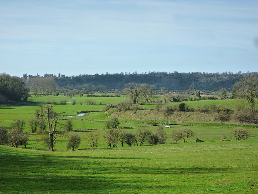
I left the churchyard and climbed Church Hill, to see a pair of proud, silent buzzards, perched on a tree so steeply below me they were at eye-level. We looked at each other for a few moments before they flew away, slowly and heavily. I’d never seen such big birds of prey so close in the wild, and then moments later two smaller sparrowhawks flitted across the sky as I trudged along a very muddy path. A solid, wide logging track proved much swifter going through Wepham Wood and I quickly emerged onto Warningcamp Hill with a view over Arundel Castle. It was from this high point that during the English Civil War, 370 years ago this year, 5,000 Parliamentarian soldiers trapped 800 Royalists in the castle, draining their water supply and cutting off food lines. After 18 days, the Royalists surrendered and the men took Arundel under heavy snow and bedded in for the harsh winter of 1643/44. (Seven years later the fleeing Charles II would stay at Amberley Castle, two miles north.)
I’d planned a meandering walk along the River Arun but the low-lying land around it was flooded, so I stayed high and went through Burpham (pronounced ‘burfam’) with its fine pub, the George & Dragon, and a 12th-century flint church (where writer and illustrator Mervyn Peake is buried in the churchyard). As I cut north through fallow farmland two red kites, with their distinctive forked tails, swooped low enough that I involuntarily ducked, clearly displaying their rusty plumage and white tips. I’d never seen them so far south. I followed the South Downs Way east along the ridge overlooking the low-lying Weald to the north and the glowing sea to the south before turning off south and back to Findon, eyes skyward.
ROUTE DESCRIPTION
- From Findon Parish Church follow footpath NW and cross A280 at Tolmare Farm jumping on to the Monarch’s Way heading W. Follow clear signs through Myrtle Grove Farm and Michaelgrove and up into woodland, being careful to follow white Monarch’s Way signs. Follow wide track through Wepham Wood. Just after emerging from woodland at Warningcamp Hill turn N at (GR: TQ045077).
- Walk to road and through Burpham and turn onto Peppering Lane to Peppering High Barn. Take bridleway to The Burgh.
- At The Burgh turn R and immediately L and follow bridleway NE to South Downs Way (SDW). Follow SDW E to barn after Sullington Hill (GR: TQ096116) and branch off R. Follow bridleway SE then S back to A280 and retrace steps back to Findon Parish Church.

Human and natural history dominate a beautiful walk across Downland near Arundel
I had imagined writing up this walk would be all about castles and churches, battles and sieges – and indeed there’s a very rich history in the area around Arundel, but it was the astonishing range of birdlife that lingered longest in my mind.
It was a cold, clear February morning when I set off from the 11th-century parish church of Findon, just north of Worthing. I would follow part of the Monarch’s Way west, a 615- mile trail following the escape of Charles II after the Battle of Worcester in 1651, before climbing onto the ridge of the South Downs and looping back. The westernmost point would be the River Arun, overlooking the great castle at Arundel.
I left the churchyard and climbed Church Hill, to see a pair of proud, silent buzzards, perched on a tree so steeply below me they were at eye-level. We looked at each other for a few moments before they flew away, slowly and heavily. I’d never seen such big birds of prey so close in the wild, and then moments later two smaller sparrowhawks flitted across the sky as I trudged along a very muddy path. A solid, wide logging track proved much swifter going through Wepham Wood and I quickly emerged onto Warningcamp Hill with a view over Arundel Castle. It was from this high point that during the English Civil War, 370 years ago this year, 5,000 Parliamentarian soldiers trapped 800 Royalists in the castle, draining their water supply and cutting off food lines. After 18 days, the Royalists surrendered and the men took Arundel under heavy snow and bedded in for the harsh winter of 1643/44. (Seven years later the fleeing Charles II would stay at Amberley Castle, two miles north.)
I’d planned a meandering walk along the River Arun but the low-lying land around it was flooded, so I stayed high and went through Burpham (pronounced ‘burfam’) with its fine pub, the George & Dragon, and a 12th-century flint church (where writer and illustrator Mervyn Peake is buried in the churchyard). As I cut north through fallow farmland two red kites, with their distinctive forked tails, swooped low enough that I involuntarily ducked, clearly displaying their rusty plumage and white tips. I’d never seen them so far south. I followed the South Downs Way east along the ridge overlooking the low-lying Weald to the north and the glowing sea to the south before turning off south and back to Findon, eyes skyward.
ROUTE DESCRIPTION
- From Findon Parish Church follow footpath NW and cross A280 at Tolmare Farm jumping on to the Monarch’s Way heading W. Follow clear signs through Myrtle Grove Farm and Michaelgrove and up into woodland, being careful to follow white Monarch’s Way signs. Follow wide track through Wepham Wood. Just after emerging from woodland at Warningcamp Hill turn N at (GR: TQ045077).
- Walk to road and through Burpham and turn onto Peppering Lane to Peppering High Barn. Take bridleway to The Burgh.
- At The Burgh turn R and immediately L and follow bridleway NE to South Downs Way (SDW). Follow SDW E to barn after Sullington Hill (GR: TQ096116) and branch off R. Follow bridleway SE then S back to A280 and retrace steps back to Findon Parish Church.


