
You could say Wast Water is photographer Mark Gilligan’s muse. Here he picks his favourite two walks from Wasdale
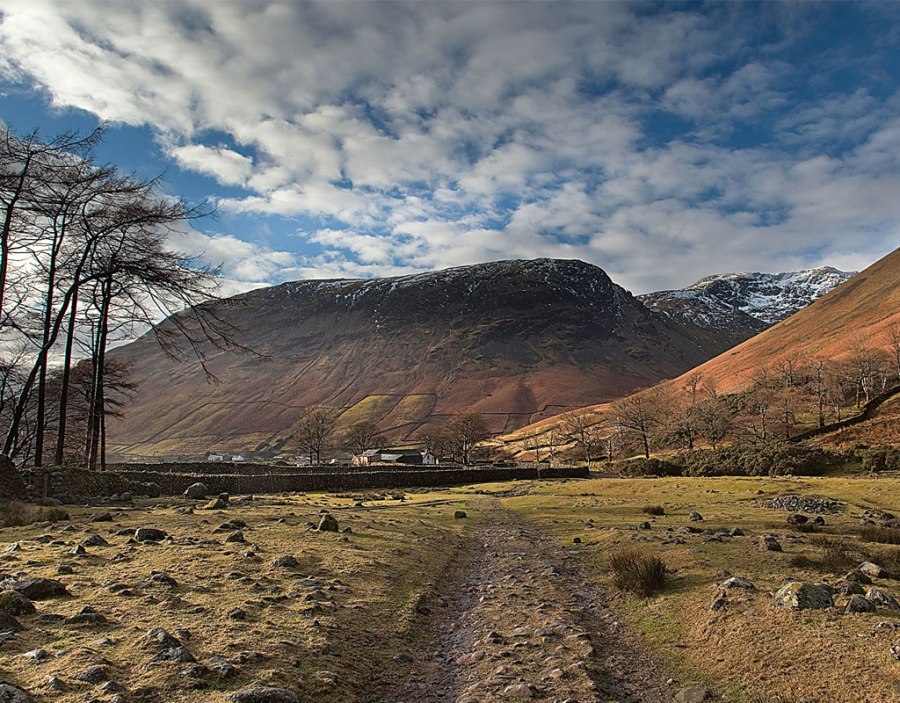
I never tire of walking around Wasdale. It is blessed with an endless array of fells, tarns and the most magnificent vistas this country has to offer. All in such a small, tight space that invites you to return time and time again. At its heart are the highest points in England and of course my own particular favourite, the deepest lake that is Wast Water. It is bounded on one side by the daunting Screes, that produce the most glorious sunrises and sunsets I have ever seen. The first walk I’ve chosen is 9km/6 miles in length, with 800m/2630ft of ascent, and takes about 6 hours; the second walk is 10km/6.5 miles, 585m/1950ft of ascent, and takes 6.5 hours.
Of course it is the pilgrimage of most to venture out atop the lofty hights of the Scafells, but for me it’s looking at them and moving around the perimeters of the water that give this area its true appeal. Whatever the time of year, it seems to have its followers, but in the spring and summer the view looking up Brown Tongue can seem like your witnessing an endless line of soldier ants going about their business. For that reason, I have chosen two routes that don’t involve ‘The Big One’ but still give you a great sense of achievement and, just as importantly, views that are awesome.
Black Sail Pass and Kirk Fell
The first involves a little bit of everything. It takes in Black Sail Pass and ascends the wonderfully positioned Kirk Fell. Always in the shadow of the big boys (literally) it may be, but it still deserves your respect. It rises above Mosedale affording fantastic views along Wast Water to the Isle of Man, Northern Ireland and Southern Scotland on clear days.
A favourite Wasdale walk
The second is actually my favourite walk. It is a shortened version of my mammoth 19-miler! It takes in Middle Fell, which on a good day has fabulous views of the ‘Pikes’, isn’t arduous but gives you a lift due to the vistas that you gain with a 360-degree sweep. The lower views are simply some of the best you’ll find in the whole of England as you skirt Wast Water and find yourself in its ‘hidden gem’ near the water house at the source of the River Irt.
Looking for a different way to experience Wasdale? Check out this walk guide, including a paddle across Wast Water!
ROUTE DESCRIPTION
ROUTE 1 – KIRK FELL VIA BLACK
- From Wasdale Head car park, make towards the Inn (don’t go in yet!), and pass between the pub and the Barn Door shop. With the beck in front of you, turn R, ignore the packhorse bridge on the L and continue along the footpath. Kirk Fell is now directly in front of you.
- Follow the path for approx 400 metres and as it forks to the R look for the signpost which will take you L along the foot of Kirk Fell. As you slowly ascend, the Ritson Falls are in the valley on L and you will enter Mosedale. A ‘bowl of fells’ almost envelop you here. It’s an imposing wall that wraps around you!
- After around 1km take the R fork and begin to climb with Gatherstone Beck on L. Rise sharply up towards Black Sail, crossing the beck as you progress.
- At the top of the pass, turn right and begin your ascent up to the summit of Kirk Fell. It is a steep ascent over Black Sail Buttress which eventually lessens as you near the top.
- From the summit, continue along the path. You will drop down, rise, then drop down to Beck Head. You are now ‘sat’ nicely between Kirk Fell and the magnificent Great Gable. Turn R and descend the path that affords great views of the valley with Wast Water to the W.
- Eventually you will be alongside the waterfalls which are spectacular when in spate. Head for the bridge that will come into view at the valley bottom. Cross and head back towards the car park.
- When you pass through Burnthwaite Farm, take the actual lane that returns to the car park and if you have time, call in at St Olaf’s church that nestles in the trees on your right hand side some 300 metres from the finish. Now you might consider calling in for that pint!
ROUTE 2 – GREENDALE CIRCULAR VIA MIDDLE FELL
- Begin at Greendale at the foot of Middle Fell. The path is usually clear but can sometimes be ‘hidden’ by bracken. Head up the obvious route to Middle Fell.
- Climb this path, heading to a well defined ridge that leads up to the summit of Middle Fell (en route there is a detour to the R that affords fantastic views of Wast Water and the valley). From the summit head N, skirting the ridge and then descend a steep path running beside Ladcrag Beck.
- This joins Nether Beck and will take you down to the road alongside the shoreline of Wast Water. Turn R along the road. There are paths that run alongside the road and I would urge you to take these.
- After approx 1.5 km you will pass the signpost and fork in the road that takes you back to Greendale. Do not turn R here. Instead, carry on towards the shelter that is above you to the R. It’s a great stopping point for the usual Wast Water photographs.
- Continue alongside Wast Water and as the road turns sharply R, don’t take it. Look straight ahead and you will see a stile in the wall directly before you. Cross it and begin your walk which will pass the front of the YHA and take you to the foot of the water.
- Continue along the path which skirts ‘the lagoon’ that opens out before you. This is the source of the River Irt. Follow the path and go through the woods. You will rise gently across a field and eventually come out opposite Woodhow Farm that houses rare and exotic goats!
- Turn R and follow the lane back past the YHA entrance. Some 100 metres further up, there is a track and a signpost on your L hand side. Follow this back across the fields to your start point at Greendale.


