

In search of the best view on ‘the island’. By Geoff Barton
What constitutes a good view? Is it all about what fills the view, the features, hills and other aspects of the landscape? Or is it more quantifiable? Can it be measured in terms of the distance you can see and the number of degrees in the panorama? Is there such a thing as a ‘best’ view?
I was intrigued recently when a friend, an Isle of Wight resident, told me of a walk I might be interested in, which features a view that he considered could be ‘the best’ on the island. The spot in question is the Worsley Monument that dates back to 1774 and stands on the downs above the villages of Godshill and Wroxall. It enjoys an outlook taking in all four points of the island’s (roughly) diamond shape.
Godshill, then, would be our start point – ideal as it’s the location of one of our favourite pubs on the island, The Taveners. The thought of one of their steak and ale pies would be ample motivation during the walk.
I awoke on the morning chosen and immediately flung open the curtains, fingers crossed for good weather. Although it was, apparently, hailing further along the coast, I was greeted with blue skies and sunshine. We set off east from Godshill, through the village and into the marshy woodland along Bleak Down. A boardwalk that has seen better days provides a path over the wettest areas, and careful footing was needed in places. After the boardwalk the route led mainly through woodland, touching on the occasional country lane. We skirted the odd field, and momentarily a narrow view would open up behind us, but on the whole the outlook was somewhat… close-range.
After following Dolcoppice Lane, we crossed a field leading to the path up St Catherine’s Down. A fallen tree blocked the route, but after clambering over (and through) it, we began our ascent. The path was wooded on one side with high bushes on the other, but then, suddenly, the first moment that I’d really been waiting for – the bushes to our right opened up, and stretching away from us was a view of the south-west island. Shimmering in the distance I could even see one of the Needles. One point down, three to go!
We continued up, and soon reached the Hoy Monument, a 72ft column erected in 1814. We then walked south along St Catherine’s Down, and finally the views started to open up around us. We stopped at St Catherine’s Oratory, built as a lighthouse in 1313 and known as the ‘Pepperpot’. We rested for a few minutes, content to take photos and take in the views. If we were headed for ‘the best’ view on the island, then this would surely run it close.
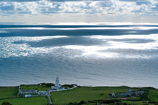
Continuing south, we descended the Down and made our way to the coastal path, stopping for lunch at a bench overlooking St Catherine’s Point lighthouse, the very southern tip of the island. Two down!
I’ve eaten at this bench several times before, and each time is a joy – the view out across the channel, and the dappled patterns on the waves created by the clouds and sunlight. Soon though, it was time to leave the bench and set off on the homeward leg of our journey, through Niton and Whitwell towards our ultimate goal of the Worsley Monument.
So what of ‘the view’, then? As we reached the monument the air was crystal clear, visibility stretching north over Cowes and the mouth of the River Medina, across the Solent all the way to the South Downs, west past the Needles to Swanage, south out over the channel to the horizon, and east past Culver Down and along the south coast of the mainland. Almost as far as the eye could see – in every direction. And all four points? Well, the Needles had disappeared below the end of Tennyson Down, as had St Catherine’s Lighthouse and some of the southern island, but – very nearly – this was a view of the whole island.
Does this qualify it as the best then? I realised as I looked out that what’s more important is how such an experience can make you feel. Earlier in the day I had been wowed by the simple beauty of the view of light and water at St Catherine’s Point, but now at the Worsley, I felt something extra. I’m a regular visitor to the island, but not until today had I felt the connection to the place as I now did. Seeing the island laid out at my feet in this way has, somehow, brought me closer to it.
“The thing I like about this view”, said my friend, pointing westwardly, “is that you can see more or less everywhere you’ve been. Beacon Alley, the Hoy Monument, the Pepperpot…”. We traced our route, enjoying the sense of accomplishment at the ground covered. We sat at the base of the monument for some time, taking in the view and periodically moving from one face of the obelisk to another, changing our outlook. Soon my stomach was rumbling – the pub was calling me – and it was time to walk back down to Godshill.
Perhaps it’s not the best view on the island – perhaps there’s no such thing – but it’s the one that I hold dearest, and a spot to which I know I’ll return soon.
ROUTE DESCRIPTION
- From the Old Smithy car park, go R along the road through the village of Godshill. Go L into West Street. Go straight on at the corner with Whitwell Road, and take the footpath R when you reach the farm. The path leads through a boggy wooded area, with a boardwalk over the wettest section.
- At the road, go R towards Holden farm. Walk through the farm, then cross the road and continue on the path opposite. When you reach the road, follow it L, and then right along Dolcoppice Lane.
- Before reaching the end of the lane, look out for a path, though a metal gate, on the right-hand side. Go across the field to another metal gate, and then up the path to the Hoy Monument.
- From the Hoy Monument, follow the top of the down S towards St Catherine’s Oratory. From there continue S, towards the road. Go through the car park at the bottom and take the path on the far side.
- The path follows the cliffs above Blackgang Chine and the southern point of the island. The bench overlooking St Catherine’s Lighthouse makes for a good lunch stop!
- The path leads towards Niton, at the road take the path marked ‘Ventnor’, which continues from slightly down the road to the right. At the end of this path follow Allotment Road to the R, which turns to a track after a few minutes. Take the L fork, then the path straight ahead.
- Cross over the road at Whitwell, then after the following track go diagonally to the L, across the field. At the road to Nettlecombe, the path continues to the R.
- The path meets another going N to S, overlooking Wroxall and Ventnor. Turn L towards the Obelisk (Worsley Monument). Continue E briefly down the hill and pick up the path back to Godshill.

In search of the best view on ‘the island’. By Geoff Barton
What constitutes a good view? Is it all about what fills the view, the features, hills and other aspects of the landscape? Or is it more quantifiable? Can it be measured in terms of the distance you can see and the number of degrees in the panorama? Is there such a thing as a ‘best’ view?
I was intrigued recently when a friend, an Isle of Wight resident, told me of a walk I might be interested in, which features a view that he considered could be ‘the best’ on the island. The spot in question is the Worsley Monument that dates back to 1774 and stands on the downs above the villages of Godshill and Wroxall. It enjoys an outlook taking in all four points of the island’s (roughly) diamond shape.
Godshill, then, would be our start point – ideal as it’s the location of one of our favourite pubs on the island, The Taveners. The thought of one of their steak and ale pies would be ample motivation during the walk.
I awoke on the morning chosen and immediately flung open the curtains, fingers crossed for good weather. Although it was, apparently, hailing further along the coast, I was greeted with blue skies and sunshine. We set off east from Godshill, through the village and into the marshy woodland along Bleak Down. A boardwalk that has seen better days provides a path over the wettest areas, and careful footing was needed in places. After the boardwalk the route led mainly through woodland, touching on the occasional country lane. We skirted the odd field, and momentarily a narrow view would open up behind us, but on the whole the outlook was somewhat… close-range.
After following Dolcoppice Lane, we crossed a field leading to the path up St Catherine’s Down. A fallen tree blocked the route, but after clambering over (and through) it, we began our ascent. The path was wooded on one side with high bushes on the other, but then, suddenly, the first moment that I’d really been waiting for – the bushes to our right opened up, and stretching away from us was a view of the south-west island. Shimmering in the distance I could even see one of the Needles. One point down, three to go!
We continued up, and soon reached the Hoy Monument, a 72ft column erected in 1814. We then walked south along St Catherine’s Down, and finally the views started to open up around us. We stopped at St Catherine’s Oratory, built as a lighthouse in 1313 and known as the ‘Pepperpot’. We rested for a few minutes, content to take photos and take in the views. If we were headed for ‘the best’ view on the island, then this would surely run it close.
Continuing south, we descended the Down and made our way to the coastal path, stopping for lunch at a bench overlooking St Catherine’s Point lighthouse, the very southern tip of the island. Two down!
I’ve eaten at this bench several times before, and each time is a joy – the view out across the channel, and the dappled patterns on the waves created by the clouds and sunlight. Soon though, it was time to leave the bench and set off on the homeward leg of our journey, through Niton and Whitwell towards our ultimate goal of the Worsley Monument.
So what of ‘the view’, then? As we reached the monument the air was crystal clear, visibility stretching north over Cowes and the mouth of the River Medina, across the Solent all the way to the South Downs, west past the Needles to Swanage, south out over the channel to the horizon, and east past Culver Down and along the south coast of the mainland. Almost as far as the eye could see – in every direction. And all four points? Well, the Needles had disappeared below the end of Tennyson Down, as had St Catherine’s Lighthouse and some of the southern island, but – very nearly – this was a view of the whole island.
Does this qualify it as the best then? I realised as I looked out that what’s more important is how such an experience can make you feel. Earlier in the day I had been wowed by the simple beauty of the view of light and water at St Catherine’s Point, but now at the Worsley, I felt something extra. I’m a regular visitor to the island, but not until today had I felt the connection to the place as I now did. Seeing the island laid out at my feet in this way has, somehow, brought me closer to it.
“The thing I like about this view”, said my friend, pointing westwardly, “is that you can see more or less everywhere you’ve been. Beacon Alley, the Hoy Monument, the Pepperpot…”. We traced our route, enjoying the sense of accomplishment at the ground covered. We sat at the base of the monument for some time, taking in the view and periodically moving from one face of the obelisk to another, changing our outlook. Soon my stomach was rumbling – the pub was calling me – and it was time to walk back down to Godshill.
Perhaps it’s not the best view on the island – perhaps there’s no such thing – but it’s the one that I hold dearest, and a spot to which I know I’ll return soon.
ROUTE DESCRIPTION
- From the Old Smithy car park, go R along the road through the village of Godshill. Go L into West Street. Go straight on at the corner with Whitwell Road, and take the footpath R when you reach the farm. The path leads through a boggy wooded area, with a boardwalk over the wettest section.
- At the road, go R towards Holden farm. Walk through the farm, then cross the road and continue on the path opposite. When you reach the road, follow it L, and then right along Dolcoppice Lane.
- Before reaching the end of the lane, look out for a path, though a metal gate, on the right-hand side. Go across the field to another metal gate, and then up the path to the Hoy Monument.
- From the Hoy Monument, follow the top of the down S towards St Catherine’s Oratory. From there continue S, towards the road. Go through the car park at the bottom and take the path on the far side.
- The path follows the cliffs above Blackgang Chine and the southern point of the island. The bench overlooking St Catherine’s Lighthouse makes for a good lunch stop!
- The path leads towards Niton, at the road take the path marked ‘Ventnor’, which continues from slightly down the road to the right. At the end of this path follow Allotment Road to the R, which turns to a track after a few minutes. Take the L fork, then the path straight ahead.
- Cross over the road at Whitwell, then after the following track go diagonally to the L, across the field. At the road to Nettlecombe, the path continues to the R.
- The path meets another going N to S, overlooking Wroxall and Ventnor. Turn L towards the Obelisk (Worsley Monument). Continue E briefly down the hill and pick up the path back to Godshill.


