
Is this the best route for Great Whernside, asks Ian Battersby?
The day had dawned with high cloud that cast a uniform grey shadow over the Dales. Nothing unusual about that, but the forecasters had promised wall-to-wall sunshine. I guessed there was nothing unusual about that either, so I swallowed my disappointment, and set out from sleepy Kettlewell, aiming for Dowber Gill. The usual approach to Great Whernside’s sweeping summit climbs unswervingly via Hag Dike. Just south of this spur is a confining gill. The map shows a path that ends at Providence Pot, but within Access Land. A steep pull out of the gill looked possible, so I set out to see for myself.
The ground was frozen solid, with a fine coating of frost feathering the edges of every rock and tree. Small cascades gurgled around serpentine bends in the beck, and glistening ice coated every stream-splashed frozen rock, hanging like stalactites from limestone ribs. The dusting of frost added millennia to the peeling corpses of fallen trees, still lying by shattered roots that had sustained them. After this enticing introduction to the gill I came to a spectacular waterfall, cascading over tiers of smooth limestone bedrock. Further on, a thrilling side stream gushed out of the land.
Towards the top of the gill, Providence Pot divides the stream, falling sheer into the black belly of Earth. Above it a green tongue of land laps at the stream, offering easier than expected access to the upper gritstone landscape of Great Whernside. Unlike on the eastern flanks of the mountain the going here is easy, through coarse grasses and short heather. What little bog I stumbled across was frozen hard. I’ll have to return when the land is thawed, but this ascent seemed easier than the hags above Hag Dike, so may well become my favourite way up.
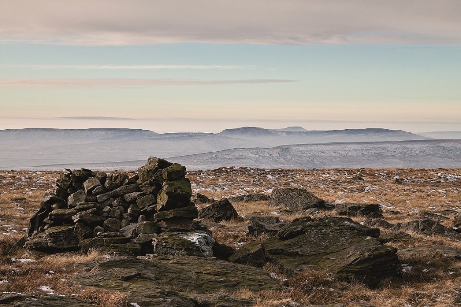
Grouse griped across the moor where every north-facing recess protected a pocket of frost. Above the hills the lid of cloud slid away, allowing sunlight to bathe the land through low haze. On the crest, water had drained from large pools, but not before freezing into surface sheets of ice that now sagged and strained. The wind blew cold over the gritstone outcrops along the edge, creating lift for an opportunist kestrel, its wings vibrating on invisible currents, before it sliced over to Tor Dike. I followed it down over land that had been flooded and frozen into a snapshot of preceding rivers of rain, so instead of sinking into bog there was another danger – of sliding uncontrollably over it where vegetation was sparse.
The day ended clear and cold, with restrained winter sun dying too early behind Old Cote Moor. As I dropped over Cam Pasture, I struggled to make out the regiments of dry stone walls dipping into darkness.
ROUTE DESCRIPTION
- Head E through Kettlewell keeping south of the beck. As road turns to track it veers N, crossing Dowber Gill Beck.
- Turn E here along the path that follows the beck east for 2km where it splits.
- Climb the spur ahead, and make your own way east across Whernside Pasture to climb Great Whernside. NNW to summit.
- Path N for 750m, then drop NW to Cam Gill Road.
- Bridleway W along Tor Dyke, turning southwest to Cam Head.
- Turn S following a bridleway down over Cam Pasture to Cam Gill Road, which descends to Kettlewell.

Is this the best route for Great Whernside, asks Ian Battersby?
The day had dawned with high cloud that cast a uniform grey shadow over the Dales. Nothing unusual about that, but the forecasters had promised wall-to-wall sunshine. I guessed there was nothing unusual about that either, so I swallowed my disappointment, and set out from sleepy Kettlewell, aiming for Dowber Gill. The usual approach to Great Whernside’s sweeping summit climbs unswervingly via Hag Dike. Just south of this spur is a confining gill. The map shows a path that ends at Providence Pot, but within Access Land. A steep pull out of the gill looked possible, so I set out to see for myself.
The ground was frozen solid, with a fine coating of frost feathering the edges of every rock and tree. Small cascades gurgled around serpentine bends in the beck, and glistening ice coated every stream-splashed frozen rock, hanging like stalactites from limestone ribs. The dusting of frost added millennia to the peeling corpses of fallen trees, still lying by shattered roots that had sustained them. After this enticing introduction to the gill I came to a spectacular waterfall, cascading over tiers of smooth limestone bedrock. Further on, a thrilling side stream gushed out of the land.
Towards the top of the gill, Providence Pot divides the stream, falling sheer into the black belly of Earth. Above it a green tongue of land laps at the stream, offering easier than expected access to the upper gritstone landscape of Great Whernside. Unlike on the eastern flanks of the mountain the going here is easy, through coarse grasses and short heather. What little bog I stumbled across was frozen hard. I’ll have to return when the land is thawed, but this ascent seemed easier than the hags above Hag Dike, so may well become my favourite way up.
Grouse griped across the moor where every north-facing recess protected a pocket of frost. Above the hills the lid of cloud slid away, allowing sunlight to bathe the land through low haze. On the crest, water had drained from large pools, but not before freezing into surface sheets of ice that now sagged and strained. The wind blew cold over the gritstone outcrops along the edge, creating lift for an opportunist kestrel, its wings vibrating on invisible currents, before it sliced over to Tor Dike. I followed it down over land that had been flooded and frozen into a snapshot of preceding rivers of rain, so instead of sinking into bog there was another danger – of sliding uncontrollably over it where vegetation was sparse.
The day ended clear and cold, with restrained winter sun dying too early behind Old Cote Moor. As I dropped over Cam Pasture, I struggled to make out the regiments of dry stone walls dipping into darkness.
ROUTE DESCRIPTION
- Head E through Kettlewell keeping south of the beck. As road turns to track it veers N, crossing Dowber Gill Beck.
- Turn E here along the path that follows the beck east for 2km where it splits.
- Climb the spur ahead, and make your own way east across Whernside Pasture to climb Great Whernside. NNW to summit.
- Path N for 750m, then drop NW to Cam Gill Road.
- Bridleway W along Tor Dyke, turning southwest to Cam Head.
- Turn S following a bridleway down over Cam Pasture to Cam Gill Road, which descends to Kettlewell.


