
Roger Butler takes an appealing walk through a quiet corner of the Cotswolds
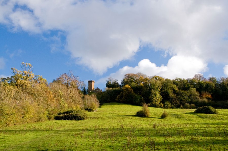
Nestled beneath Edge Hill, Radway is the perfect English village with a tiny chapel, a few creaking cottages and a couple of old barns. Beyond a pond filled with waterweed, my first view of the four-mile escarpment was dominated by a castellated skyline turret built as an 18th century folly. Now an unusual pub, its flanks were wrapped in dense beech trees which cascaded downhill to meet the flowerrich pasture.
This northernmost finger of the Cotswolds projects well into Warwickshire and is quite different from those better known bits further south. Firstly, there are no tourists and, secondly, the local russet ironstone creates a distinctive landscape character. Shakespeare may have played around here, but in his day Edge Hill would have been open and bare. The wooded slopes arrived long after the first battle of the Civil War was fought in the fields below the ridge in 1642. The Parliamentarians and the Royalists slogged out a draw, but it’s said their primitive cannons could be heard more than 20 miles away.
A narrow path slipped through mature trees, occasional yews and a few suckering elms. The slopes were wet and King John’s Lane – muddy and strewn with leaves – crept up the hill like a dark historic artery. Hundreds of troops had marched down here on the morning of the battle with standards raised and nerves ablaze. The path broke free from the trees on Spring Hill, which was just like stepping straight onto the South Downs. Steep grass plunged down to a maze of ridge and furrow which swayed all the way to Meon Hill in the west and Brailes Hill in the south. A newly fallen oak branch showed how exposed it can be up here, where the wind can howl all the way from Wales.
To the east of the escarpment, the land fell away in great scallops which might have been carved by a giant excavator. The map doesn’t really do justice to these empty twisting valleys, and their sheltered slopes were a complete contrast to airy Edge Hill. Mixed plantations, thick hedges and clumps of gorse all nestled into a patchwork of scenery with more folds than a piece of origami. Shenington was another showstopper, with a network of interlocking greens and a lane that tumbled down to a fast-flowing stream. Hornton nestled in a deep valley, beyond which I dropped towards the Sor Brook. The soil was the colour of peanut butter and just as sticky, but the track into Ratley was dry. There must be a dozen different ways out of this secretive village and I was soon back on top of the edge. Wizened trees lined the steps known as Jacob’s Ladder, which led down to a damp meadow and Radway’s cluster of ironstone houses.
ROUTE DESCRIPTION
- From pond by old village green take track past chapel and walk SE uphill to reach woods.
- Turn R through trees and continue on narrow path to A422. Turn L, then R after 70m and past stables to path to Spring Hill. Continue S for 1km, then turn L on good track.
- Cross lane, continue on path E, then SE, and take path on R after wood leading to Shenington. At houses, turn L into village, L again at road, then take path on L down into valley.
- Cross footbridge and walk N. Fork R at end of wood and take path NE to meet road. Turn L, then R at next road for 250m.
- Take track on L leading to Hornton. Walk N through village to meet road. Cross onto farm track, go past Poplars Farm then descend N into valley. Cross stream and follow path uphill to track. Turn L into Ratley.
- Take lanes and paths out of village to join road leading NW to Edge Hill. Cross road, take steps through trees. Go through gate and walk down to Radway to return to start.

Roger Butler takes an appealing walk through a quiet corner of the Cotswolds
Nestled beneath Edge Hill, Radway is the perfect English village with a tiny chapel, a few creaking cottages and a couple of old barns. Beyond a pond filled with waterweed, my first view of the four-mile escarpment was dominated by a castellated skyline turret built as an 18th century folly. Now an unusual pub, its flanks were wrapped in dense beech trees which cascaded downhill to meet the flowerrich pasture.
This northernmost finger of the Cotswolds projects well into Warwickshire and is quite different from those better known bits further south. Firstly, there are no tourists and, secondly, the local russet ironstone creates a distinctive landscape character. Shakespeare may have played around here, but in his day Edge Hill would have been open and bare. The wooded slopes arrived long after the first battle of the Civil War was fought in the fields below the ridge in 1642. The Parliamentarians and the Royalists slogged out a draw, but it’s said their primitive cannons could be heard more than 20 miles away.
A narrow path slipped through mature trees, occasional yews and a few suckering elms. The slopes were wet and King John’s Lane – muddy and strewn with leaves – crept up the hill like a dark historic artery. Hundreds of troops had marched down here on the morning of the battle with standards raised and nerves ablaze. The path broke free from the trees on Spring Hill, which was just like stepping straight onto the South Downs. Steep grass plunged down to a maze of ridge and furrow which swayed all the way to Meon Hill in the west and Brailes Hill in the south. A newly fallen oak branch showed how exposed it can be up here, where the wind can howl all the way from Wales.
To the east of the escarpment, the land fell away in great scallops which might have been carved by a giant excavator. The map doesn’t really do justice to these empty twisting valleys, and their sheltered slopes were a complete contrast to airy Edge Hill. Mixed plantations, thick hedges and clumps of gorse all nestled into a patchwork of scenery with more folds than a piece of origami. Shenington was another showstopper, with a network of interlocking greens and a lane that tumbled down to a fast-flowing stream. Hornton nestled in a deep valley, beyond which I dropped towards the Sor Brook. The soil was the colour of peanut butter and just as sticky, but the track into Ratley was dry. There must be a dozen different ways out of this secretive village and I was soon back on top of the edge. Wizened trees lined the steps known as Jacob’s Ladder, which led down to a damp meadow and Radway’s cluster of ironstone houses.
ROUTE DESCRIPTION
- From pond by old village green take track past chapel and walk SE uphill to reach woods.
- Turn R through trees and continue on narrow path to A422. Turn L, then R after 70m and past stables to path to Spring Hill. Continue S for 1km, then turn L on good track.
- Cross lane, continue on path E, then SE, and take path on R after wood leading to Shenington. At houses, turn L into village, L again at road, then take path on L down into valley.
- Cross footbridge and walk N. Fork R at end of wood and take path NE to meet road. Turn L, then R at next road for 250m.
- Take track on L leading to Hornton. Walk N through village to meet road. Cross onto farm track, go past Poplars Farm then descend N into valley. Cross stream and follow path uphill to track. Turn L into Ratley.
- Take lanes and paths out of village to join road leading NW to Edge Hill. Cross road, take steps through trees. Go through gate and walk down to Radway to return to start.


