

North Devon’s remarkable history and the largest dune landscape in Europe fascinate Tim Gent
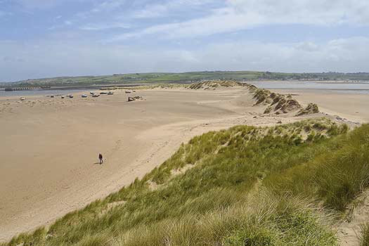
Despite the sea and sand, Braunton Burrows on the North Devon coast is far from a cosy beach destination. So wild are the dunes and the tides that scour its estuary edge that the Royal Marines choose to train here. Walk the burrows and you’re more likely to see a camouflaged landing craft than a sun lounger.
The area was first used for a military role during World War Two, when troops destined for the horrors of the Normandy landings practised a range of offensive skills across the burrows and beyond. A small group of concrete landing craft mock-ups still stand among the dunes and bramble patches as eerie monuments to past bravery.
In dramatic contrast, this exotic dune landscape, one of the largest in Europe, was later to portray the Cybermen’s home planet in an early Dr Who programme. Pink Floyd twice succumbed to the allure of this bizarre sand setting, using the Burrows in their film The Wall and on the album cover for A Momentary Lapse of Reason, and more recently the dunes formed a backdrop in Robbie Williams’ Angels video. Today, the burrows provide a home to a splendid range of rare flowering plants, including French toadflax. Introduced in the 1890s, it grows nowhere else in Britain.
For bird lovers the area is just as important, with curlew, dunlin, ringed plover, godwits, sanderling, turnstone and numerous other waders, a regular sight at the right time of year. Oystercatchers are particularly plentiful, with in excess of 2,000 sometimes recorded. A list of all the flora and fauna within a mile or two of Crow Point would run for pages. All this results in the burrows forming the core of Britain’s first UNESCO Biosphere Reserve. This international designation places the estuary alongside Uhuru (Ayers Rock) and Yellowstone National Park. Not a bad place for a walk then.
Hayley, Tristan and I set out from a useful car park at the end of the toll road (£1.50 at time of writing) to Crow Point. The South-West Coast Path is well marked, and apart from a detour to find the replica landing craft (GR: SS462331), we followed it north along the inner edge of the dunes towards Saunton. A short road section intervened here, but soon led back to the footpath, which dropped to the vast expanse of Saunton Sands. Feeling as if we were embarking on a desert crossing, we set off south along the beach and back to Crow Point.
Good as the beach is, with views across to Westward Ho! and out to Lundy Island, it is worth taking the chance to deviate. Wild flowers speckle the dunes at almost all times of year. With Devon Red Cattle busy keeping unwanted vegetation at bay, and occasional relics of a less peaceful time, any meander into the burrows repays the effort.
ROUTE DESCRIPTION
- From the car park follow the South-West Coast Path N to Saunton.
- Turn L on meeting the road (B3231), then L again soon after to rejoin the path to the beach.
- Follow the beach, or the edge of the dunes, S to Crow Point.
- Round the point, then wind N around the edge of the bay (with care at high tide) back to the car park.

North Devon’s remarkable history and the largest dune landscape in Europe fascinate Tim Gent
Despite the sea and sand, Braunton Burrows on the North Devon coast is far from a cosy beach destination. So wild are the dunes and the tides that scour its estuary edge that the Royal Marines choose to train here. Walk the burrows and you’re more likely to see a camouflaged landing craft than a sun lounger.
The area was first used for a military role during World War Two, when troops destined for the horrors of the Normandy landings practised a range of offensive skills across the burrows and beyond. A small group of concrete landing craft mock-ups still stand among the dunes and bramble patches as eerie monuments to past bravery.
In dramatic contrast, this exotic dune landscape, one of the largest in Europe, was later to portray the Cybermen’s home planet in an early Dr Who programme. Pink Floyd twice succumbed to the allure of this bizarre sand setting, using the Burrows in their film The Wall and on the album cover for A Momentary Lapse of Reason, and more recently the dunes formed a backdrop in Robbie Williams’ Angels video. Today, the burrows provide a home to a splendid range of rare flowering plants, including French toadflax. Introduced in the 1890s, it grows nowhere else in Britain.
For bird lovers the area is just as important, with curlew, dunlin, ringed plover, godwits, sanderling, turnstone and numerous other waders, a regular sight at the right time of year. Oystercatchers are particularly plentiful, with in excess of 2,000 sometimes recorded. A list of all the flora and fauna within a mile or two of Crow Point would run for pages. All this results in the burrows forming the core of Britain’s first UNESCO Biosphere Reserve. This international designation places the estuary alongside Uhuru (Ayers Rock) and Yellowstone National Park. Not a bad place for a walk then.
Hayley, Tristan and I set out from a useful car park at the end of the toll road (£1.50 at time of writing) to Crow Point. The South-West Coast Path is well marked, and apart from a detour to find the replica landing craft (GR: SS462331), we followed it north along the inner edge of the dunes towards Saunton. A short road section intervened here, but soon led back to the footpath, which dropped to the vast expanse of Saunton Sands. Feeling as if we were embarking on a desert crossing, we set off south along the beach and back to Crow Point.
Good as the beach is, with views across to Westward Ho! and out to Lundy Island, it is worth taking the chance to deviate. Wild flowers speckle the dunes at almost all times of year. With Devon Red Cattle busy keeping unwanted vegetation at bay, and occasional relics of a less peaceful time, any meander into the burrows repays the effort.
ROUTE DESCRIPTION
- From the car park follow the South-West Coast Path N to Saunton.
- Turn L on meeting the road (B3231), then L again soon after to rejoin the path to the beach.
- Follow the beach, or the edge of the dunes, S to Crow Point.
- Round the point, then wind N around the edge of the bay (with care at high tide) back to the car park.


