
James Carron takes a meander over the remote hills above Glen Lethnot
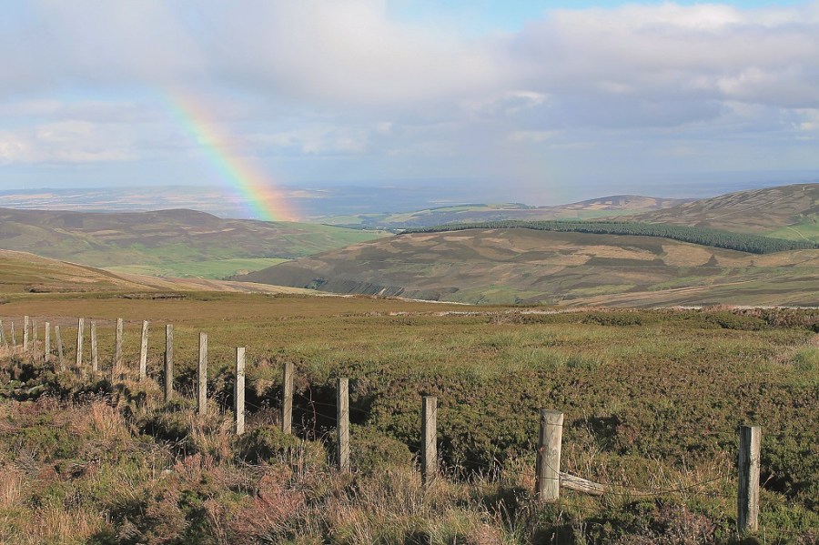
THERE ARE FEW places in Eastern Scotland that feel as remote as Glen Lethnot. Down in the valley, where houses are few and far between, an air of loneliness prevails. It is a secluded vale, isolated from the world by a battery of sentinel hills. Ascend the high ground, however, and extensive panoramas unfold, proof if it were needed that Glen Lethnot is not quite as introverted as first appearances suggest.
Located right in the heart of the valley and linked by a broad, elevated ridge, Tamhilt and Hill of Mondurran offer an unrivalled outlook not only over the glen but also right across the county towards the coastal fringes of Angus and the North Sea beyond.
Aware that the bulk of the day’s ascent would present itself early on, I hastened up the track. It rose sharply through a wide arc before straightening out to cross rough pasture where sheep grazed amid the ruins of old cottages and enclosures, evidence that Glen Lethnot once had a more buoyant population.
At the top of a series of tight hairpin bends I paused briefly to catch breath before sauntering up into the col between Craig Duchrey and Tamhilt. A brief detour to the top of Craig Duchrey was rewarded with views over the glen to Hill of Wirren.
Back in the col I rejoined the track for a spell of level walking. It was not long, however, before I was climbing once again. The route snakes up the eastern flank of Tamhilt before descending briefly, running alongside a fence, to a junction. Here I turned left, passing through an opening in the fence. The track doubled back on itself before striking west over Tamhilt.
At the next junction, I walked straight ahead, an elevated highway conveying me effortlessly along the ridge. Down to the right, the pink edifice that is Hunthill Lodge was clearly visible as was the Water of Saughs and, above it, the craggy bowl of Corrie na Berran.
With a stiff breeze caressing the high ground, I was glad to find shelter midway along the ridge. A short spur on the left led me to a stalkers’ hut where I ducked out of the wind.
Fortified, I returned to the main track and let it lead me west, up on to the airy summit of Hill of Mondurran. A prominent cairn, separated from the track by an easily negotiated fence, marked the high point.
Clambering back over the fence, I followed the track down into the next col, where it ended abruptly. Here, a wooden stile marked the start of a rather vague path that conveyed me round the eastern slope of Mount Sned. Careful footing was required to avoid patches of squelching moss.
As I progressed, the route became clearer, leading to a second stile. I did not cross but instead turned left, following the adjacent fence across heather moor to join a track that led me on to Hill of Garbet. This was the last real climb of the day and, after reaching its high point, the track ambled over the ridge to a junction, where I descended Shank of Ducharr. Beyond a stream crossing, the gradient eased and the route swung east.
Close by there are four memorial stones. One commemorates the life of Peter Grant, a Jacobite who fought at the Battle of Culloden in 1745 where he was captured and taken to Carlisle. After escaping he found refuge in Glen Lethnot. At the age of 100, he was awarded a pension by King William IV and became known as the King’s oldest enemy.
Skirting the southern slope of Nathro Hill, the track descends to Nathro Farm then drops steeply to cross Burn of Calletar by a bridge sitting amid a cluster of holiday huts. A surfaced lane beyond guided me back down to the asphalt.
ROUTE DESCRIPTION
- Walk W on gravel track, passing under overhead cables. Follow track as it climbs steeply through wide bend before rising NW to gate. Go through and continue straight ahead, ignoring peaty track branching R. Climb zigzags to col between Craig Duchrey and Tamhilt.
- Remain on track as it curves L and ascends the eastern flank of Tamhilt. Descend briefly to junction. Turn L and pass through open gateway in fence. Follow track as it doubles-back on itself, then curves R and leads W over Tamhilt. At next junction, go straight ahead.
- At junction midway along ridge, continue straight ahead. After passing through a gap in a fence, the track curves R and momentarily descends before climbing to summit of Hill of Mondurran.
- Descend W on track to col between Hill of Mondurran and Mount Sned. Cross wooden stile and walk S on initially indistinct path contouring round E slope of Mount Sned. Continue to second wooden stile. Do not cross this. Instead bear L and follow fence SE to meet track.
- Follow track E up on to Hill of Garbet and continue E over broad ridge to track junction. Turn L and descend N over Shank of Ducharr. Beyond stream crossing, follow track E. Ignore a track branching L and continue to next junction. Go L, descending to base of valley. Cross two small streams and walk E to Nathro Lodge.
- Follow track E to Nathro Farm then continue down to cross Burn of Calletar by bridge. Above bridge, join surfaced lane, turn R and follow this through Craigendowie Farm to meet Glen Lethnot road.
- Turn L and walk 1.5km on single-track road.

James Carron takes a meander over the remote hills above Glen Lethnot
THERE ARE FEW places in Eastern Scotland that feel as remote as Glen Lethnot. Down in the valley, where houses are few and far between, an air of loneliness prevails. It is a secluded vale, isolated from the world by a battery of sentinel hills. Ascend the high ground, however, and extensive panoramas unfold, proof if it were needed that Glen Lethnot is not quite as introverted as first appearances suggest.
Located right in the heart of the valley and linked by a broad, elevated ridge, Tamhilt and Hill of Mondurran offer an unrivalled outlook not only over the glen but also right across the county towards the coastal fringes of Angus and the North Sea beyond.
Aware that the bulk of the day’s ascent would present itself early on, I hastened up the track. It rose sharply through a wide arc before straightening out to cross rough pasture where sheep grazed amid the ruins of old cottages and enclosures, evidence that Glen Lethnot once had a more buoyant population.
At the top of a series of tight hairpin bends I paused briefly to catch breath before sauntering up into the col between Craig Duchrey and Tamhilt. A brief detour to the top of Craig Duchrey was rewarded with views over the glen to Hill of Wirren.
Back in the col I rejoined the track for a spell of level walking. It was not long, however, before I was climbing once again. The route snakes up the eastern flank of Tamhilt before descending briefly, running alongside a fence, to a junction. Here I turned left, passing through an opening in the fence. The track doubled back on itself before striking west over Tamhilt.
At the next junction, I walked straight ahead, an elevated highway conveying me effortlessly along the ridge. Down to the right, the pink edifice that is Hunthill Lodge was clearly visible as was the Water of Saughs and, above it, the craggy bowl of Corrie na Berran.
With a stiff breeze caressing the high ground, I was glad to find shelter midway along the ridge. A short spur on the left led me to a stalkers’ hut where I ducked out of the wind.
Fortified, I returned to the main track and let it lead me west, up on to the airy summit of Hill of Mondurran. A prominent cairn, separated from the track by an easily negotiated fence, marked the high point.
Clambering back over the fence, I followed the track down into the next col, where it ended abruptly. Here, a wooden stile marked the start of a rather vague path that conveyed me round the eastern slope of Mount Sned. Careful footing was required to avoid patches of squelching moss.
As I progressed, the route became clearer, leading to a second stile. I did not cross but instead turned left, following the adjacent fence across heather moor to join a track that led me on to Hill of Garbet. This was the last real climb of the day and, after reaching its high point, the track ambled over the ridge to a junction, where I descended Shank of Ducharr. Beyond a stream crossing, the gradient eased and the route swung east.
Close by there are four memorial stones. One commemorates the life of Peter Grant, a Jacobite who fought at the Battle of Culloden in 1745 where he was captured and taken to Carlisle. After escaping he found refuge in Glen Lethnot. At the age of 100, he was awarded a pension by King William IV and became known as the King’s oldest enemy.
Skirting the southern slope of Nathro Hill, the track descends to Nathro Farm then drops steeply to cross Burn of Calletar by a bridge sitting amid a cluster of holiday huts. A surfaced lane beyond guided me back down to the asphalt.
ROUTE DESCRIPTION
- Walk W on gravel track, passing under overhead cables. Follow track as it climbs steeply through wide bend before rising NW to gate. Go through and continue straight ahead, ignoring peaty track branching R. Climb zigzags to col between Craig Duchrey and Tamhilt.
- Remain on track as it curves L and ascends the eastern flank of Tamhilt. Descend briefly to junction. Turn L and pass through open gateway in fence. Follow track as it doubles-back on itself, then curves R and leads W over Tamhilt. At next junction, go straight ahead.
- At junction midway along ridge, continue straight ahead. After passing through a gap in a fence, the track curves R and momentarily descends before climbing to summit of Hill of Mondurran.
- Descend W on track to col between Hill of Mondurran and Mount Sned. Cross wooden stile and walk S on initially indistinct path contouring round E slope of Mount Sned. Continue to second wooden stile. Do not cross this. Instead bear L and follow fence SE to meet track.
- Follow track E up on to Hill of Garbet and continue E over broad ridge to track junction. Turn L and descend N over Shank of Ducharr. Beyond stream crossing, follow track E. Ignore a track branching L and continue to next junction. Go L, descending to base of valley. Cross two small streams and walk E to Nathro Lodge.
- Follow track E to Nathro Farm then continue down to cross Burn of Calletar by bridge. Above bridge, join surfaced lane, turn R and follow this through Craigendowie Farm to meet Glen Lethnot road.
- Turn L and walk 1.5km on single-track road.


