Heather Morning, Mountain Safety Advisor with The Mountaineering Council of Scotland, takes a look at mountain locations in the Scottish Highlands that are the scenes of frequent accidents, and offers advice on how you can avoid falling victim to them
A look through Scottish Mountain Rescue statistics reveals the most common accident ‘blackspots’. The tourist track on Ben Nevis is top of the league table for Mountain Rescue call-outs to one specific location in Scotland. Other challengers are the Aonach Eagach and Coire na Tulaich on Buachaille Etive Mor in Glen Coe, the Cuillin of Skye and the Goat Track in Coire an t-Sneachda in the Cairngorms. Blackspots are marked on the maps to the right, with recommended alternative routes marked in red. These are provided as guidelines only.
Terrain traps
A terrain trap is a geographical feature where avalanched snow will accumulate because it has nowhere else to run. It may be a depression or flattening in the hillside, such as a gully, corrie basin or even an abrupt change in slope angle which would allow avalanche debris to accumulate rather than carry on down the mountainside.
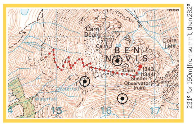
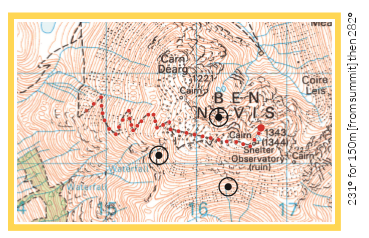
Ben Nevis Tourist Track
Start of track at GR: NN125728
Due to the Ben’s iconic status as the highest mountain in the UK, it attracts huge numbers of people. Recent figures from the John Muir Trust electronic people-counters on the tourist track reveal that a staggering 20,000 people a month ascend Ben Nevis via this route alone during the busy summer months. By the law of averages, the more people there are, the more accidents there will be.
For your average hillwalker, the tourist track is a straightforward constructed footpath with very little objective danger. Problems come from users’ poor fitness levels, predisposed medical conditions, inadequate clothing and equipment, lack of navigation skills or poor general ‘hill sense’. Common navigation errors occur in various locations.
The map below highlights where people often end up. Cairns are now in place to mark the correct descent route from the summit on the tourist track (a grid bearing of 231° for 150m from the summit, then a grid bearing of 282°) but in deep snow or a white-out they won’t always be seen, so make sure you can navigate without them. See mcofs. org.uk/ben-nevis-navigation.asp for detailed information.
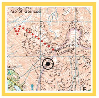
Aonach Eagach, Glen Coe
Start descent at GR: NN133581
‘Notched Ridge’ is the Gaelic translation of this infamous ridge, which gives us a clue as to why the Aonach Eagach is up there on the’ leaderboard’ of blackspots. It is often claimed to be the most difficult ridge traverse on the mainland. Certainly to link the two Munros of Meall Dearg and Sgorr nam Fiannaidh requires a good head for heights across exposed horizontal sections, combined with some steep scrambling both in ascent and descent.
Accidents do happen on the ridge traverse itself, but it’s the descent that catches people out. The ridge is normally tackled from east to west and descent off the western end by any route is steep and loose. Most accidents have occurred while descending the traditional route directly down the side of the Clachaig Gully. Even those with the best of knees will find this 825m of descent direct to the Clachaig Inn gruelling.
With many loose rocky steps underpinned with consequential drops below. A far more user-friendly alternative is to descend north off the final summit and pick up the track which descends west from the Pap
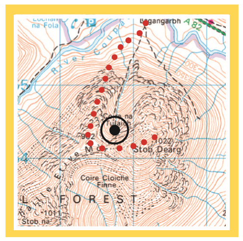
Coire na Tulaich, Buachaille Etive Mor
GR: NN217545
Look in any Munro guide and the suggested route will take you directly up through Coire na Tulaich en-route to the popular Munro of Sgurr Dearg on Buachaille Etive Mor. The path is now constructed virtually all the way up to the head of the corrie. However, in winter this corrie accumulates a huge amount of snow, stripped from the high ground to the south with the prevailing southwesterly winds. There have been several incidents of multiple fatalities as a result of deep burials in this serious ‘terrain trap’.
This route MUST be avoided during periods of high avalanche risk. Check out the Scottish Avalanche Information Service website prior to your visit (www.sais.gov.uk) and consider your options. Your option may be to leave this one for another day or choose an alternative route to minimise the risk. An alternative route is shown on the map following the line of a ridge to the west of the coire.
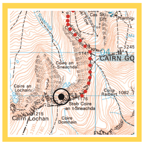
The Goat Track, Coire an t-Sneachda, Cairngorms
GR: NH991029
In summer, this ‘track’ is steep, loose and badly eroded and provides one of only a few options for exiting Coire an t-Sneachda to access the Cairngorm Plateau. A well-established, constructed track takes you from the Coire Cas car park at 635m into the boulder field in the base of Coire an t-Sneachda then the terrain dramatically changes.
This ease of access is almost certainly the reason why a high number of incidents occur here. In winter, Coire an t-Sneachda is arguably the most accessible and therefore popular venue for winter mountaineers. The ‘Goat Track’ is a popular descent route back into the Coire for climbers having completed routes. It faces north and in winter, accumulates snow stripped from the plateau with the prevailing south-westerly winds.
Knowledge of avalanche conditions is vital in addition to the use of axe and crampons to negotiate this access route safely. For both summer and winter, alternatives are available – see map below.