
Mapping software has been around for many years and there are quite a few different products. Of those I’ve tried I think RouteBuddy is the best for desktop computer use. It runs on both Windows PCs and Apple Macs. It can also be used on Apple iPhones and iPads but not as yet on other smartphones and tablets. An Android version is promised, which I’m looking forward to as I use Android devices. This review is for the Windows version.
There are two big advantages to mapping software compared with paper maps. The first is being able to plan routes easily, with information on distance, ascent and more provided. The second is being able to print maps. The last might seem unnecessary but print-outs can cover just those areas needed and have routes on them. Unlike with paper maps you can print the same map again without the route or with different routes. Notes can be written on the maps and after a trip they can be filed away for future reference or reminiscence.
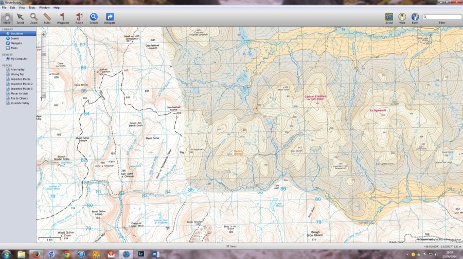
I judge mapping software primarily by how well it can perform these two functions and RouteBuddy does both extremely well. It’s quite easy to use and there’s a good online manual. Using RouteBuddy on Windows 7 on my quite old PC it operates smoothly and without any crashes or freezes.
Recently I used RouteBuddy to plan my 2014 The Great Outdoors Challenge route. The route planning tools are flexible and I was able to produce a continuous route for the whole walk and then split it into daily sections.
Before finalising any day’s route I could see how much distance and ascent was involved and back track if this seemed a bit too much. I then printed out A4 size maps with the main TGOC route plus foul weather alternatives marked on them. There were 27 sheets in total, with a total weight of 155 grams. I’d have needed 9 paper maps to cover the same route, at a total weight of 747 grams.
Route cards can be viewed for routes and also printed out. These contain information for the total walk and for each leg including grid references, distance, ascent, descent and even estimated time.
Both OS and Harveys maps are available for RouteBuddy. A neat feature I really like stitches the two together so that you can plan routes using both and not be limited by the restricted areas covered by Harveys maps. OS 1:50,000 and 1:25,000 maps can also be stitched together. To see more detail you can zoom in on any map and for a greater area you can zoom out. This means the same maps can be used for overall and detailed planning.
You can also view maps and routes on a satellite view by using the Aerial or Earth buttons. As well as giving more of an idea of the terrain this can show details, including tracks, that aren’t on the maps.
Map prices vary depending on the type and size of the map. OS Landranger size maps are £4.99 each, Harveys British Mountain Maps a rather expensive £29.99. OS National Park maps vary from £2.99 and £7.99. If you’re going abroad there are maps for the USA and France but as yet nowhere else. More countries should be covered in the future.
Downloading maps is a slightly long-winded process. After purchase RouteBuddy sends download links and licence codes. Installing the maps is then straightforward.
Overall RouteBuddy does everything I want from mapping software. The company is a dynamic one, constantly improving and upgrading, and I’m looking forward to seeing what comes next. There is a free trial version with a few maps so you can try it out and see if it’s for you.


