
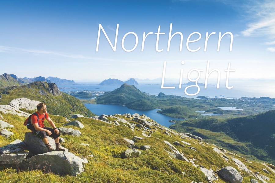
Cat Scully takes a whistlestop tour of the beautiful Lofoten and Vesterålen islands of Northern Norway, finding a fascinating land of mountains and fjords, and some rather youthful residents.
In our September 2018 issue, you’ll find our 35-page Scandinavia Outdoors supplement, which aims to demonstrate that Norway, Sweden and Finland can justifiably claim to be home to Europe’s best backpacking.
We’ve selected some features on Scandi hiking from our archives, and over the coming weeks we’ll be republishing them online in full for the first time.
This feature was first published in the April 2014 issue of The Great Outdoors
Northern Light by Cat Scully
From the top of Småtingdan mountain, some 700 metres above sea level, I gazed at the surrounding scenery. Below, the Norwegian Sea lapped at the tidy coastal inlets of the Lofoten Islands’ shores, while up top, fresh arctic air swept over the granite peaks. The clear blue sky made for perfect visibility: a colour-by-number of blue, green and grey. The view was exhilarating, with jagged mountains poking up from the sea from every direction.
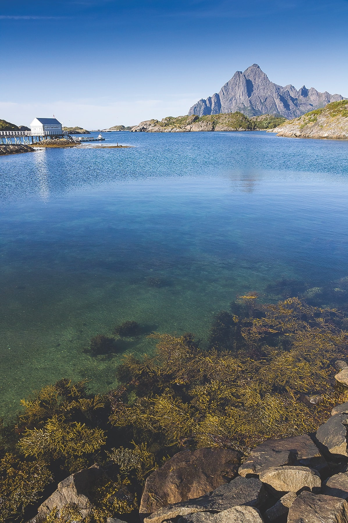
The Lofoten Islands (also referred to as simply Lofoten) extend along 160km of coastline in the north of Norway. The archipelago has provided shelter and livelihood for fishermen and their families for at least 1,000 years. Cod is the reason this part of the Arctic Circle has been populated. Yet while the seas have been claimed and charted, the mountains have, for the most part, been left untouched.
The day before, I had disembarked at Harstad Narvik Airport, a two-hour flight from Oslo and starting point for Lofoten Islands visitors, to be greeted by a captivating backdrop of striking mountains and crystal clear coastline – and this was the view from the arrivals lounge. My first impression was of a landscape that reminded me of Western Canada, with its two-tone split of green mountains above azure water. My second impression was that there is a high percentage of stunningly attractive people here. Everyone is beautiful. Seriously. Everyone.
As my hiking group assembled with bags and laced boots slung over shoulders, our guide for the trip marched over and introduced herself with a handshake strong enough to crush a walnut. Elisabeth Müller is a trilinguist, expedition leader, avid traveller, experienced hiker, member of the Lofoten kayak club and daily arctic swimmer. I assumed she was in her late 50s. She’s 67.
Elisabeth took us to the cosy and ‘very typical’ Borsen Spiseri restaurant in the picturesque fishing harbour of Slovær. We dined on arctic char and stockfish cod while she explained what our short tour would involve.
All levels of hiking catered for in Lofoten
© Cat Scully
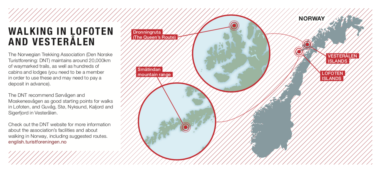
A six-hour walk was planned for the following day, which was to cover about 13 kilometres among the Småtindan mountain range, circling back to Kabelvåg. We were told it was not a well-known route and that the incline would be tough, but were promised beautiful scenery. The second walk, in two days’ time, was a popular trail known as ‘Dronningruta’ (‘The Queen’s Route’) at the northern tip of the Vesterålen archipelago, between the fishing villages of Nyksund and Stø. This 15km route was also considered challenging and came with the promise of excellent coastline views and varied and interesting terrain.
Our accommodation that night was at a group of converted fishing huts set right on the harbour water. Elisabeth had assured us the Lofoten air would leave even the most troubled insomniac sleeping like a baby and that sounded very appealing, but before turning in I stood outside a while to admire the uninterrupted view of the Småtindan range, its glacially sharp peaks imposing by twilight.
After a breakfast of rye cracker bread, cold cuts and Norway’s national treasure: brown cheese – Brunost – plus a shot of pure fish oil that Elisabeth assured us was a local hiking ritual, we regrouped at the start of the day’s walk.
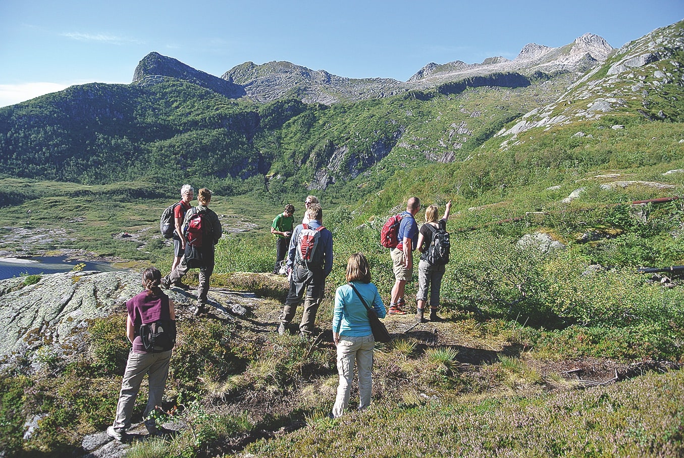
The route began with an immediate incline of alpine meadowland which hugged the edge of the mirror-surfaced lake Stor-Kongsvatnet. As we headed upwards, trees quickly gave way to wet mossy ground decorated with cotton flower, purple Alpine bistort and wild cloudberry shrubs. Absorbing the scenery (and incline) we managed to walk straight into several cleverly camouflaged Rock Ptarmigan. Perturbed by our intrusion, they flapped over our heads, while the quickest of our human troupe attempted to catch a dashing photo.
“The route began with an immediate incline of alpine meadowland which hugged the edge of the mirror-surfaced Lake Stor-Kongsvatnet”
Along the route, Elisabeth encouraged us to try the wild cloudberries, a Norwegian delicacy, hard to come by and full of antioxidants. They tasted like buttery raspberries. We filled our bottles up at fresh mountain springs. Then, after about three hours of walking, we stopped to rest and admire our surroundings. We sat down on the cusp of a change in scene: below lay a green and vibrant landscape; above, treeless, rocky terrain leading to the summit.
We had been informed several times that our hiking route (and, generally speaking, most routes in the area) was considered challenging by most visitors. “There are no leisurely strolls here,” I believe was the phrase. There are plenty of walks to choose from in these islands, and most are all-dayers. The best options for visitors are known as ‘DNT routes’, a network of clearly marked trails developed from local footpaths, sheep trails and ski paths maintained by the Norwegian Trekking Association. They are marked throughout with red ‘T’s painted on cairns and posts.
After lunch it was time for the summit push. The mountain was bare and windy, with large boulders underfoot. The incline was steep and we had to watch where to take our next step, but with a little hand-balancing and lunging it was a straightforward ascent to the jagged summit, from where we gazed down upon the landscape below. We could clearly see the glacial lake, the sea, islands and neighbouring mountains beyond. As the wind rippled against our jackets and immersed our bodies with its fresh arctic air, I was moved by how healthy and clean the view, the atmosphere and the walk itself felt. Thinking aloud, I asked what Lofoteners do when severe winters keep them indoors. Kristian, our local guide, scoffed: “I don’t need to sit inside and watch TV. When it’s winter I come here with my skis. This environment is my TV!”
Glacial rock formations turn a hike into a geology lesson
© Matthijs de Winter
After enjoying some time at the top to take in the unbroken view, we started on our descent. “Back to the hot tube!” Kristian announced (it is true that Norwegians speak nearly faultless English, however I couldn’t help but catch several deviations: ‘hot tube’ for hot tub being one example).
With cans of Arctic Beer in our hands, we joked and chatted in the ‘hot tube’ about the day’s hike, the true beauty of the place and its lucky inhabitants. Tilting our heads up, the night sky gave us what felt like a private screening of the cosmos. Elisabeth mused about the landscape and the outdoor lifestyle it offers. “There is a magic about this place,” she said. “If I am tired, the land gives me energy.” She followed her statement with a hearty chuckle and reminded us about an optional early arctic dip.

Nyksund
The continued, thriving existence of Nyksund is down to luck, perseverance and the vision of a creative thinker. Back in the 1980s a German student named Ssemjon Gerlitz came to the village as a kind of hippie helping hand. He initially intended to live cheaply with other students within the buildings left standing by the once prosperous fishing community, the last of whom had left in 1975. But Ssemjon was so inspired by the ghost town’s skeleton that the short stay transformed into long-term.
Almost single-handedly, he restored and renovated Holmvik Brygge to what is now his ‘living museum’/guesthouse. The building, historically a caviar and stockfish production house, is now a quirky and cosy lodging for hikers, outdoorsy couples, reclusive writers and the famous going incognito. A room which once housed 12 fishermen now sleeps two, but the view out the window can’t be far off what those fishermen gazed upon.
The success of Ssemjon’s Holmvik Brygge inspired others to restore more buildings and now the village has come back to life, complete with several restaurants, a few year-round residents, an active church/ community hall and, best of all, voices being spoken along its raised wooden walkways. For an intriguing and enjoyable hiking base, Nyksund is one of the most unique places you can possibly visit.
© Image © Cat Scully
Turquoise Sea of Lofoten
© Matthijs de Winter
The next morning, after another shot of fish oil, we headed north by car to Fiskebøl to take the ferry across to Melbu on the shores of the island of Hadseløya in Vesterålen. (It is worth noting that to get around northern Norway, you need to be prepared to fork out for private car hire or a group minibus, as public transport options are fairly minimal.) From Melbu, we drove futher north to Nyksund, a resurrected abandoned fishing village and our base for the next walk. As well as planning the hike, we spent much of the day chatting to Ssemjon, who had restored the village, about Nyksund’s unusual history and how he came to be living there.
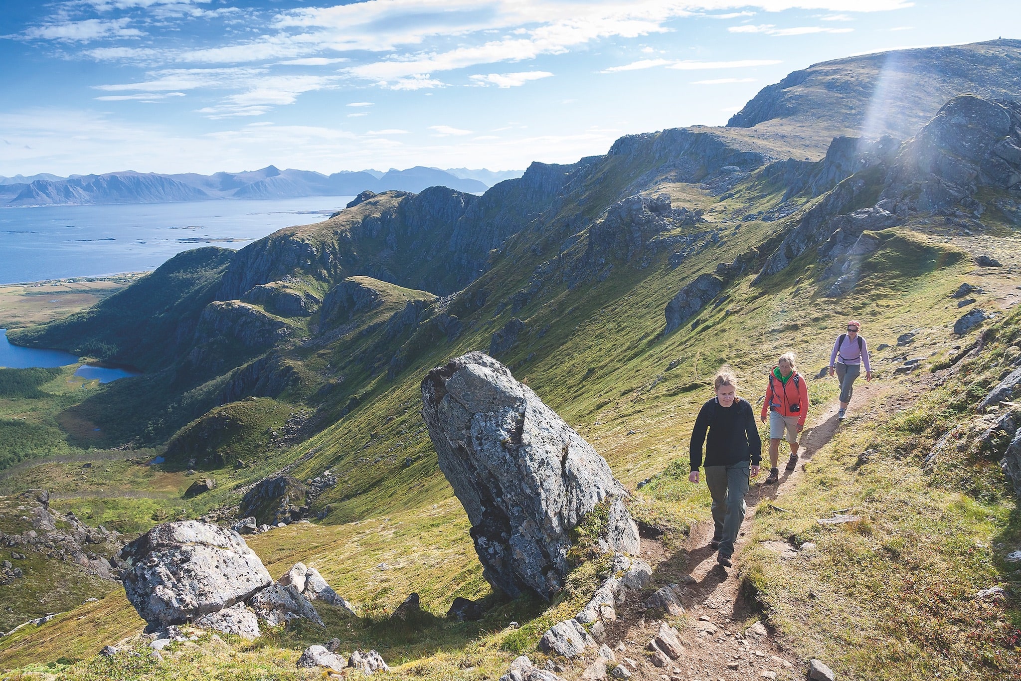
Another deep sleep was abruptly ended at 5am as the sun streamed in. I looked out my window to see an enchanting view of sunshine lighting up the mountain route we were to walk that day: Dronningruta, aka the Queen’s Route, a 15km path so named in honour of Norway’s Queen Sonja who walked it in 1994. It follows a sheep trail up the mountainside from Nyksund to the village of Stø (or vice versa) with terrain varying from soft peat to weather-beaten mountaintop, and returns via the coast. Most of the trail is high and narrow, and careful foot placement is needed, but what hurts the knees is generous to the eyes with high and magnificent views and excellent lookouts to the sea 450 metres below.
Peering down, I could see turquoise shoreline revealing hidden beaches, while glacial valleys made parts of the landscape look like New Zealand’s cousin. Stopping at the halfway point, we opened our daypacks for some stockfish and nuts. Ssemjon flopped down. He inhaled a deep breath. “After a hard day’s work I sit down and look out at views like this. It instantly relaxes me.” In unison, we all nodded as if to say: “How could it not?”
We took our time getting to Stø, not wanting the day to finish. You couldn’t fault the Queen’s Route, it was the perfect day-walk: a gorgeous landscape, acceptably rigorous inclines and declines, sunshine and the refreshing Norwegian air. I had heard Elisabeth emphasise the need to get involved within the landscape in order to fully enjoy the region. She had mentioned the phrase ‘active tourism’ and had stressed how the age of bus tourism or ‘baby-fed’ tourism was dying. Her words lingered in my mind with each step I took along the Dronningruta. The soundlessness of the peat path absorbing our footsteps helped to focus my mind on thoughts of the surrounding environment. Great glacial grooves carved the mountainside and giant boulders provided excellent platforms for lookouts onto isolated beaches. It all seemed so immense and untouched.
In Stø we regrouped for a final coffee and bar of chocolate (I had had enough stockfish for one lifetime). Rosy-cheeked and thankful for the calories, I sat down to look around at the landscape. The scene, like seemingly everything else I’d experienced in Norway, was fresh and healthy. Black and white kittiwakes flew towards the mountain crags, a gentle breeze rippled the serene harbour, while hikers descended the mountain with the sun on their backs. The answer to Elisabeth’s youthfulness and to Norwegian fitness stared back at me. This clean arctic air was a magic potion. It was true what I had heard over the past few days; this is an environment that re-energises and invigorates. All you have to do is breathe it in.
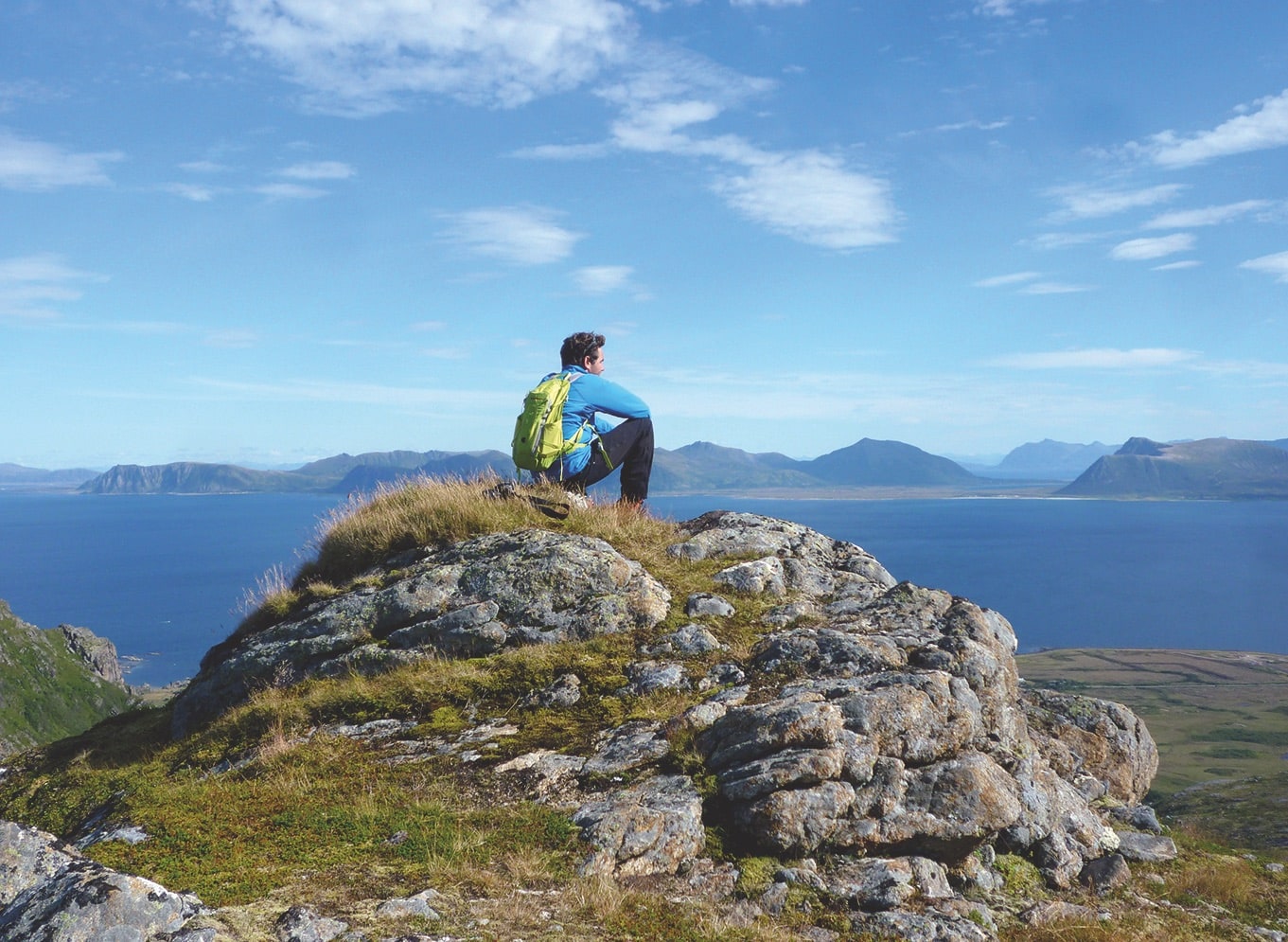
Looking out over Queen’s Route
© Cat Scully
Header image © Matthijs de Winter


