“A moment of overconfidence could ruin a whole day of good navigational decisions.”
This is part of our series of reader submissions on getting lost and lessons learned the hard way. To read more entries, and to find out how to submit your own, see this page.
Inaki Diaz de Etura is a long-distance backpacker from Spain who has completed many of the world’s classic thru-hikes, including the Pacific Crest Trail, Colorado Trail, Haute Route Pyrenees, and more. He blogs at viajarapie.info – a superb resource on long-distance backpacking, gear, technique, trips and more – and is active on Twitter at @viajarapie.
This is a simple, non-dramatic experience with a very important lesson to be learned that I have tried to apply ever since.
It happened back in the early 2000s when I had planned a summer thru-hike on a remote area, unknown to me, over exposed, mostly trail-less terrain. I wanted to assess my route-finding during the previous months to gain confidence on my skills. GPS handsets were a rather new thing back then. I got a basic, non-map-capable one for the summer trip but I didn’t have it with me on the day of this story.
One of the tests I wanted to do was navigating a whiteout. In early winter I chose an overcast day where the mountaintops were covered. I climbed on top of a main ridge where I found the right environment for the job: seamless snow cover, thick fog and otherwise relatively mild conditions with only moderate cold and wind, given the exposure. It wasn’t a full whiteout as the snow cover was thin and I could still see protruding rock. The ridge was several miles long with frequent safe escape routes and no real chance of getting seriously stranded or lost unless I had an accident.
“Just a few yards from the safety of a ridge fence to follow, I departed in what I thought was the right direction without checking map or compass”
This ridge was familiar terrain for me, a very popular walk in my local hills that I had done many times before in all seasons. Still, when I got to the top and left behind the relative safety of my climbing route, it felt intimidating. In front of me was a football-field-wide, featureless flat with no visible reference points other than the rocks sticking out of the crusty, wet snow.
I worked with map and compass, navigating from rock to rock in the intended line of travel. All should be cool as long as I didn’t find myself climbing down consistently.
After a couple of miles of this, I started going up the first of four successive peaks over more exposed, steeper terrain that was trickier to traverse – and, at the same time, simpler to navigate. First peak, tick. Second peak, tick, and I started to progress towards lower ground, knowing the most difficult part was over and I was still on track.
I reached the summit area of the third peak and eventually the small antenna at its far end. This point is only a few yards from the top of a ski lift and a fence marking the limits of the ski domain even though none of these were visible due to the dense fog. The resort was not yet open for the season so the sense of isolation was intense. I had met nobody for the whole day, yet I was feeling confident that it was going to be easy from there on. I took a brief break, using the tiny antenna building as a windbreak before resuming the walk.
And then I made a mistake: I relaxed.
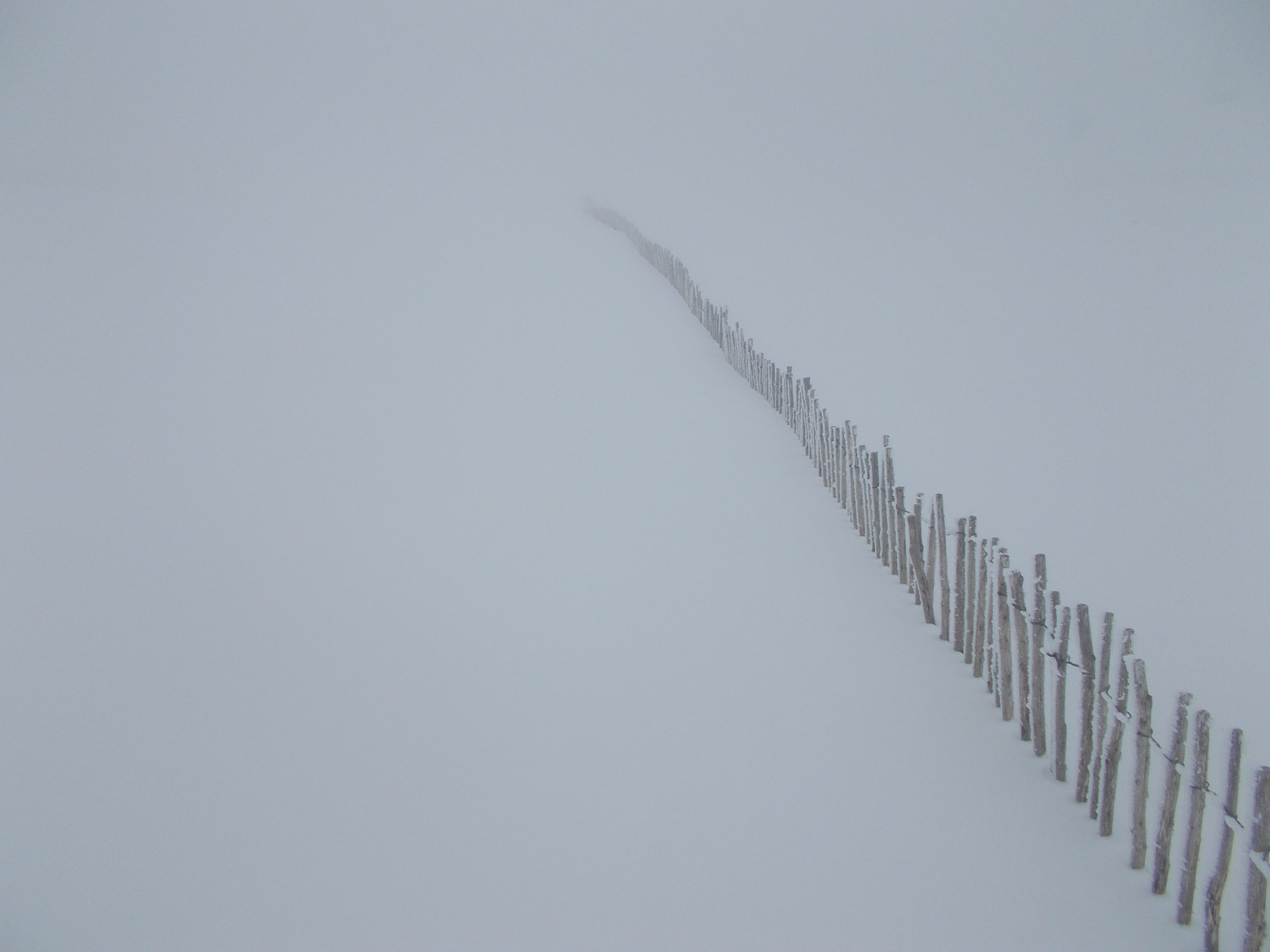
I had been clinging to my compass bearings for the whole day as if my life would depend on them, which in an over-dramatic way it did. At least my assessment would depend on them and all was going well. Here, just a few yards from the safety of a ridge fence to follow, I departed in what I thought was the right direction without checking map or compass. After a short while, I still hadn’t met the upper end of the fence. I should have checked my compass here but I didn’t. I could have tried to retrace steps back to the summit and started again from there but I was overconfident and I didn’t. Instead I went with the worst possible solution: trying to assess my error on the go and applying an unverified correction course.
“Assessing direction is difficult, even with such reference points as a known location and a known slope, and it’s too easy to go off course and not realise until who knows when. In such instances, the compass is invaluable”
After a short while, the terrain was not matching my expectations and I had no idea where I was. All of a sudden and to my relief I met a ski lift on what I felt was the wrong side of my course. The lift and the hillside were obviously right, it was me that was wrong and confused. I had no idea how I ended up there.
The rest was rather straightforward. I followed the lift up, found the fence and followed it downwards towards safety, my newfound euphoria tarnished by a reality check: I got lost, if only for a few minutes.
This is very typical of a full whiteout, as I was in at that moment. Assessing direction is difficult, even with such reference points as a known location and a known slope, and it’s too easy to go off course and not realise until who knows when. In such instances, the compass is invaluable. I should have used it one last time.
A moment of overconfidence could ruin a whole day of good navigational decisions. I try to remember this lesson to this day.
Read more in our reader series ‘Getting lost: lessons learned the hard way’