Langdale isn’t just the Pikes. Ronald Turnball takes it all the way on this Langdale walk from Elterwater to Mickleden
Langdale: whether you’re talking Pikes or car parks, it’s just about the busiest place in Lakeland. So when you want to wander lonely as a cloud, you have to be clever about it. The first clue for cloudwanderers is the name. Langdale is long. You don’t have to do it from Dungeon Ghyll. Wordsworth himself says to start from Grasmere – it’s the only actual hill route in his Guide to the Lakes. I didn’t want my Langdale quite that long – around 5-6 hours – so I started at Elterwater village, walking 16km/10 miles and climbing 865m/2837ft.
But these clouds don’t know their poetry. Those in Langdale weren’t wandering lonely as a Wordsworth. Rather, they were crowded together as close as cars in the Langdale pay-and-display. Waterproof trousers went on straight away for the sodden bracken above Elterwater’s car park.
Harrison Stickle
But when it came to solitude of the human kind, the grey day was a help – and so were the five kilometres that separate Elterwater from any normal way to Harrison Stickle. I wandered lonely as (not a cloud but) a poet, on small paths or none, all along that hummocky, lumpy ridgeline. A few hill names have been stuck on the map: Silver Howe, Raw Pike, Blea Rigg. But it’s actually just rocky knolls, and grassy glens, and pale sunspecks on the quarry spoil of lower Langdale. Bright Beck lived up to its name: not just lively with rainwater, but specked with the tiny yellow tormentil.
Camping? You’ll want a gas stove. Here’s our review of five of the best.
Suddenly the air split with a sharp crack of thunder, but much worse. The cloud moved apart with a blast of sulphur-smelling air, and the noise went on and on; it was now like a freight train heard from a few inches away. Pebbles and lumps of grey pumice clattered onto the rocks, and far above, the whole mountainside spilt open with a red glare. Smoke and ash choked the sky, as the massive landslide clattered and tumbled to a stop. Fortunately for me, all this happened 400 million years ago. A solitary sheep posed on the welded-together rubble, the rock called ‘block tuff’ that today makes up Pavey Ark.
Stickle Tarn
A light drizzle brings out the broken-up texture of the landslide boulders. At the same time it discourages some of the Stickle Tarn trekkers. But you know what? Stickle Tarn is at its best on a grey day of drizzle. Pavey Ark drips dismal above the water with little raindrop rings in it. The tower of Harrison Stickle wafts in and out like the landscape equivalent of the dance of the seven veils.
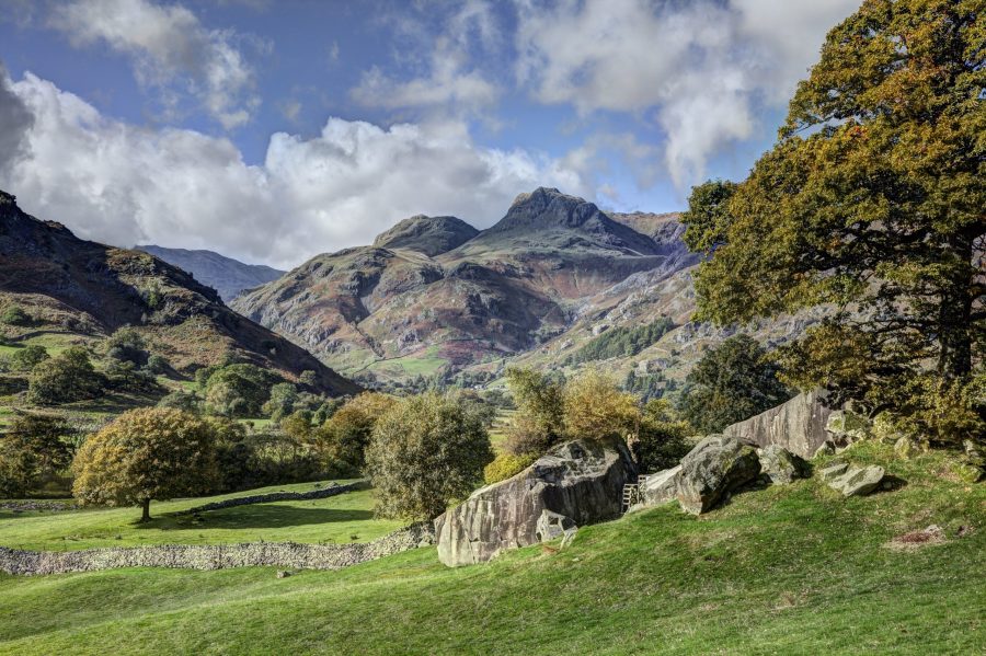
Dungeon Ghyll
The full length of Langdale means coming down by the Sticks Pass. It means half an afternoon enjoying the Pikes again, looking upwards, and from every angle. The wide stony spaces of Mickleden lead out to the field patterns of Dungeon Ghyll. Sculptural shapes of the quarry tailings, then grey-green oakwoods dripping into swirly brown waters. The river rumbles in the dusk under Elterwater bridge, and the Britannia Inn’s lights are twice as welcoming when reflected in wet paving.
Bringing your dog into the hills can be a rewarding experience, but is your dog ready? Check out our guide here.
ROUTE DESCRIPTION
- Head NE, up road, across Red Bank road, and up to small pass above Dow Bank.
- Turn up L and head NW along any ridge path to Blea Rigg; then down SW (faint path) to Stickle Tarn.
- From NE corner of tarn, take path up Bright Beck then left up E ridge to Pavey Ark.
- Cross Harrison Stickle and Pike of Stickle, then go down NW over Martcrag Moor to Langdale Comb.
- Turn L down pitched path: then follow wide path down Mickleden and above Old and New Dungeon Ghyll hotels. Take New DG driveway out to car park.
- Take track E, to rejoin road; at once turn off S across Langdale Beck.
- Track heads downstream on right bank. Cross stream and take signed bridleway along south edge Chapel Stile. After Wainwright’s Inn, cross footbridge and turn L downstream, to Elterwater bridge.
Photo: Shutterstock
Langdale isn’t just the Pikes. Ronald Turnball takes it all the way on this Langdale walk from Elterwater to Mickleden
Langdale: whether you’re talking Pikes or car parks, it’s just about the busiest place in Lakeland. So when you want to wander lonely as a cloud, you have to be clever about it. The first clue for cloudwanderers is the name. Langdale is long. You don’t have to do it from Dungeon Ghyll. Wordsworth himself says to start from Grasmere – it’s the only actual hill route in his Guide to the Lakes. I didn’t want my Langdale quite that long – around 5-6 hours – so I started at Elterwater village, walking 16km/10 miles and climbing 865m/2837ft.
But these clouds don’t know their poetry. Those in Langdale weren’t wandering lonely as a Wordsworth. Rather, they were crowded together as close as cars in the Langdale pay-and-display. Waterproof trousers went on straight away for the sodden bracken above Elterwater’s car park.
Harrison Stickle
But when it came to solitude of the human kind, the grey day was a help – and so were the five kilometres that separate Elterwater from any normal way to Harrison Stickle. I wandered lonely as (not a cloud but) a poet, on small paths or none, all along that hummocky, lumpy ridgeline. A few hill names have been stuck on the map: Silver Howe, Raw Pike, Blea Rigg. But it’s actually just rocky knolls, and grassy glens, and pale sunspecks on the quarry spoil of lower Langdale. Bright Beck lived up to its name: not just lively with rainwater, but specked with the tiny yellow tormentil.
Camping? You’ll want a gas stove. Here’s our review of five of the best camping stoves.
Suddenly the air split with a sharp crack of thunder, but much worse. The cloud moved apart with a blast of sulphur-smelling air, and the noise went on and on; it was now like a freight train heard from a few inches away. Pebbles and lumps of grey pumice clattered onto the rocks, and far above, the whole mountainside spilt open with a red glare. Smoke and ash choked the sky, as the massive landslide clattered and tumbled to a stop. Fortunately for me, all this happened 400 million years ago. A solitary sheep posed on the welded-together rubble, the rock called ‘block tuff’ that today makes up Pavey Ark.
Stickle Tarn
A light drizzle brings out the broken-up texture of the landslide boulders. At the same time it discourages some of the Stickle Tarn trekkers. But you know what? Stickle Tarn is at its best on a grey day of drizzle. Pavey Ark drips dismal above the water with little raindrop rings in it. The tower of Harrison Stickle wafts in and out like the landscape equivalent of the dance of the seven veils.
Dungeon Ghyll
The full length of Langdale means coming down by the Sticks Pass. It means half an afternoon enjoying the Pikes again, looking upwards, and from every angle. The wide stony spaces of Mickleden lead out to the field patterns of Dungeon Ghyll. Sculptural shapes of the quarry tailings, then grey-green oakwoods dripping into swirly brown waters. The river rumbles in the dusk under Elterwater bridge, and the Britannia Inn’s lights are twice as welcoming when reflected in wet paving.
Bringing your dog into the hills can be a rewarding experience, but is your dog ready? Check out our guide here.
ROUTE DESCRIPTION
- Head NE, up road, across Red Bank road, and up to small pass above Dow Bank.
- Turn up L and head NW along any ridge path to Blea Rigg; then down SW (faint path) to Stickle Tarn.
- From NE corner of tarn, take path up Bright Beck then left up E ridge to Pavey Ark.
- Cross Harrison Stickle and Pike of Stickle, then go down NW over Martcrag Moor to Langdale Comb.
- Turn L down pitched path: then follow wide path down Mickleden and above Old and New Dungeon Ghyll hotels. Take New DG driveway out to car park.
- Take track E, to rejoin road; at once turn off S across Langdale Beck.
- Track heads downstream on right bank. Cross stream and take signed bridleway along south edge Chapel Stile. After Wainwright’s Inn, cross footbridge and turn L downstream, to Elterwater bridge.
Photo: Shutterstock