
Ian Battersby moves fast and light over this Wetherlam and Coniston’s Old Man walk
THE OLD MAN OF CONISTON is well placed for a quick and agile sortie, and that was my intention as I drove to the high car park on Walna Scar Road – but then I spied an unfamiliar path from the car and curiosity overpowered common sense. With sunshine bathing the fells I changed my plan to include this novel path and tag Wetherlam onto the trip. The total route I’d planned would be 13km/8 miles and with 1000m/3300ft of ascent – quite the leg stretcher.
It was already well into the day, so I began at pace, jogging down the lane to reach my path, which coiled along a contour beneath forbidding rocky steeps, negotiating soft ferns that frilled the hillside folds. In the sky above, swallows swept through the insect communities. Below the path, the gradient dived into trees crowding a turbulent rush of water that bore through soil and rock.
Into the Coniston Fells
The path ends at the bridge that spans the gorge cut by Church Beck. Upstream the valley broadens, revealing the scars of bygone mines that turned the Old Man grey. The ridge to Wetherlam climbs behind an odd terrace of cottages that must have served the workers who inflicted these wounds, rising to the greener pastures of the Coniston Fells, where Wetherlam rolled out the grassy spur that saw me to the summit.
The view looks out from the limits of Lakeland’s high ground. From here mountains shrink, dipping into the cobalt cut of Coniston Water, bobbing briefly over low hills clad in conifer, before slipping away into Morecambe Bay. On the right the Old Man of Coniston exhibits natural crags too. This wall of broken rock rises to meet the panorama, carrying with it two tarns that snuggle into offshoots of this northern ridge. In the morning they dazzle in sunshine, but after noon, when the sun is lost behind the mountain, these waters take on a darker persona.
Don’t get lost! Here’s our guide to 12 crucial navigation skills.
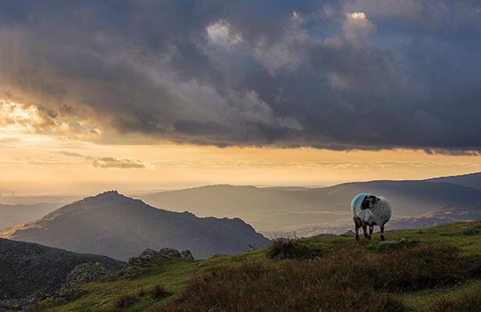
A Lake District sunset
Looking north the Central Fells were struggling with invading cloud, inky bodies bloodied at the base in dying sun. I hurried on, storming Swirl How, concerned that this impulsive menace would quench my sunset over the sea, but the mountains were more magnificent for it. Hints of flaming orange and red were set beneath the glower of the squall. The ridge fluoresced, hinting at copper, the metal that lured the miners here, as clefts in cloud shifted around an ebbing sun. A tear opened over the Old Man’s head to honour a sliver of moon.
Night came quickly under building cloud as I dropped over the shoulder into muted shelter. Synthetic lights flickered through the shadowed valley as I followed an unexplored, unmarked path down the southern ridge down to Walna Scar Road, my descent overlooked by dark crags lost in gloom.
Another route you might enjoy is our guide to walking Black Combe.
ROUTE DESCRIPTION
- Walk ENE down Walna Scar Road for 1km to sharp double bend. Take path contouring N below crags to bridge Church Beck.
- Follow track NW for 250m, fork right towards cottages, then footpath climbing N to col
- Fork left at the col, continuing climbing N to Wetherlam.
- Path descending WSW, then climbing Prison Band to reach Swirl How.
- Take the ridge path S, dropping to Little How Crags, then climbing to The Old Man of Coniston.
- Path (unmarked on OS maps) descends the south ridge, then at about 600m drop down to the right to meet the Goat’s Water path.
- Descend SE to reach the Walna Scar Road bridleway, then ENE to car park.


