The Wastwater screes present one of England’s finest mountain spectacles says Norman Hadley.
This is an unmatched display of ruggedness, plunging into deep water. When gentle light plays upon the stilled surface of the lake, the contrast between savage and soft is breathtaking. It’s well worth getting to grips with both the ridge above and the shore path beneath, even if the latter has its detractors. You’ll have seen thousands of photographs of the Wastwater Screes, and they form the right-hand frame for one of the Lake District’s most celebrated views. Yet the two summits that crown the screes are relatively little-visited, and the shore path, wending its absurd way through a vast, tilted rubble-field, encourages a lot of visitors to stay safely on the north shore admiring the scenery from comfort of the roadside. So the shore path needs to be carefully caveated. There are boulder-hopping sections akin to traversing a scrapyard full of discarded washing machines. There are slithery sections where the line of the path may have been obliterated by a recent slide. If that doesn’t sound fun to you, there’s the option of reversing your steps along the ridge.
Wastwater Screes: route description
START/FINISH: Cinderdale Bridge NY128038. Don’t make the mistake of thinking this is anywhere near Cinderdale Common (which is in Lorton) | MAPS: OS Explorer South-western Lake District OL5 (1:25k), Harvey Ultra Map Lake District West (1:40k) | DISTANCE: 16.6 km / 10 miles | ASCENT: 800m / 2630ft | DURATION: 6 hours
1. NY128038: From the distinctive triangle of roads (with the car park tucked away in the trees on the western edge of the triangle), take the road heading south crossing the bridge over the River Irt, the outpouring from Wastwater.

The Screes from the far side; the shore path can be seen picking its way across the central fan. Credit: Norman Hadley
2. NY128037: Turn almost immediately left on the track to Easthwaite Farm. Follow this, past the farm for about a kilometre and a half. If you reach the pumping station at the foot of the lake, you’ve overshot waymark (3) by a couple of minutes, but you’ll be rewarded with one of the finest views these islands have to offer.

Yewbarrow reflected in the tranquil Wastwater outflow. Credit: Norman Hadley
3. NY143037: Turn right to pick up a track onto the open fell. The crags of Whin Rigg rise impressively on your left. Depending on the season, you may see or hear the resident peregrine falcons wheeling the updraughts. The track works its way up the side of the deeply-gashed Greathall Gill then branches severally, but all paths ultimately slant up and to the left, onto a grassy plateau with an easy walk to the summit of Whin Rigg.

“Small children should be equipped with either reins or parachutes”. Credit: Norman Hadley
4. NY152034: From Whin Rigg, follow the escarpment north-eastwards. If the prospect from below caused you to expect a rocky, knife-edge arete, the reality on the ground is hands-in-pockets easy, but the views are sensational. The drop on your left is as vertiginous as a peregrine’s stoop, with several opportunities to peer down on the chaotic tumble below. Small children should be equipped with either reins or parachutes. There is mercifully little loss of height to the dip between the two tops, then only another 120 metres of reascent the other side, on simple grassy slopes.
The fine array of fells around Wasdale, seen from Illgill Head. Credit: Norman Hadley
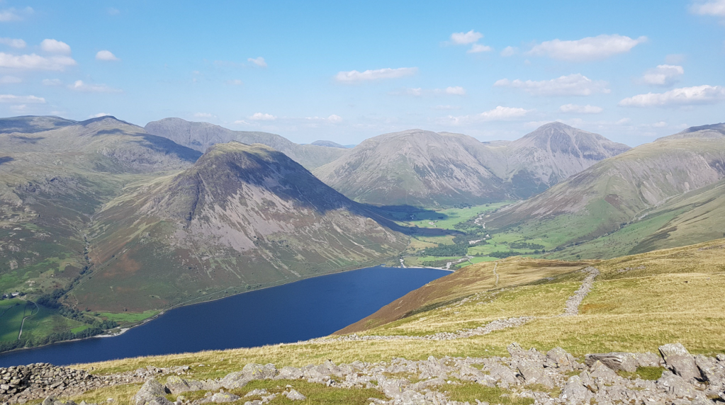
5. NY169050: From the second summit, Illgill Head, the view focuses in on the tremendous array of peaks encircling Greendale, Mosedale and Wasdale Head. Yewbarrow, in particular, looks sensational end-on. Now is the time to decide whether to return along the ridge or do the whole loop. Assuming you want to experience the walk in all its diverse glory, descend broad, grassy slopes towards Wasdale Head, converging with and picking up the beautiful slanting bridleway coming down from Burnmoor Tarn. Note the remarkable and charming double-humped packhorse bridge over Hollow Gill as you descend.
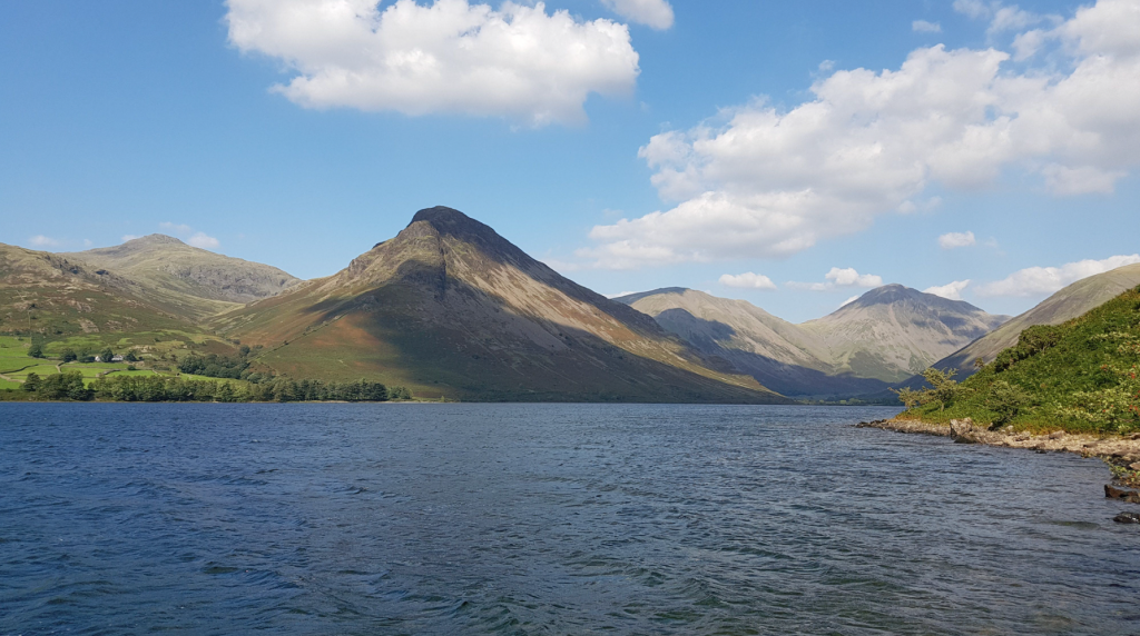
Red Pike, Yewbarrow, Kirk Fell and Gable from the shore path. Credit: Norman Hadley
6. NY184072: Turn sharply back on yourself to the left, picking up the shore path. At first, this offers easy walking. past Wasdale Head Hall Farm. If you see goats at the farm, this is a portent of what you’re about to become. The route becomes a wild ride, with bracken and saplings eking out a precarious existence on chaotic jumbles of rocks. Yes, it’s uncomfortably gnarly in places but there’s nowhere else like it – in England, at least. If you’re looking for an unforgettable, unique expedition to a Lost World, this is a treat. Other walking memories may coalesce and blur, but Wastwater stands out on a whole other level.
A glorious summer’s day at the lakefoot. Credit: Norman Hadley
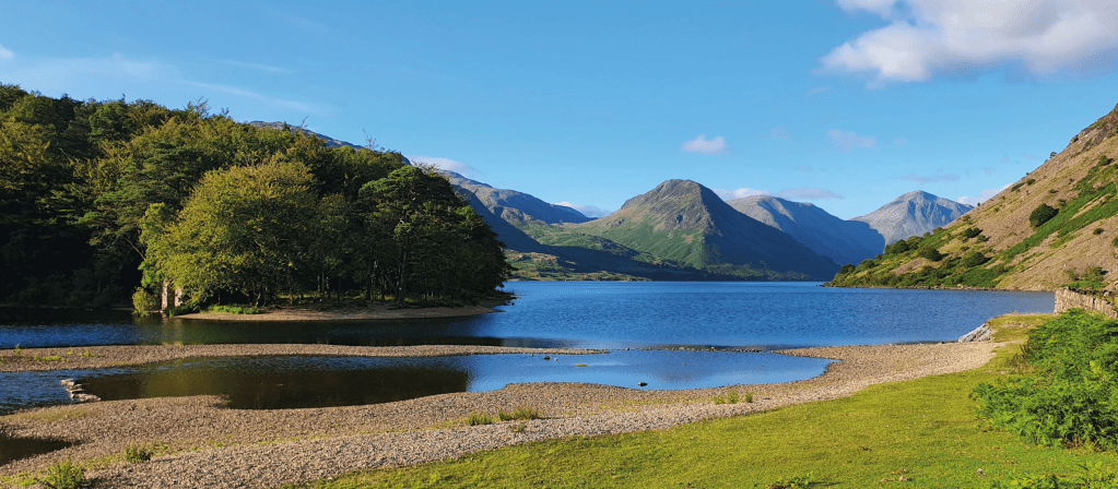
7. NY147039: At the foot of the lake, pass the pumping station with its stupendous views up Wastwater. The word iconic is vastly overused but this prospect, the physical basis of the stylised Lake District National Park logo, surely qualifies. Allow time for photography, paddling or swimming here. When you’re ready to peel yourself away, go straight ahead downriver, rejoin the Easthwaite Farm track and follow familiar ground back to the start.
Further information
PUBLIC TRANSPORT: Trains will get you to Ravenglass and, in summer, a shuttle bus runs into Wasdale.
TOURIST INFORMATION: www.visitlakedistrict.com, 01539 822222