
Phoebe Smith takes a surprising Norfolk walk
Nothing beats the feeling you get reaching the summit of a mountain – except perhaps for the sheer elation felt when completing your first long-distance path. For me, the Peddars Way and Norfolk Coast Path was my first foray into the world of National Trails. At 155 kilometres – the shortest of the 15 routes that make up the network – it seemed an easily achievable choice, plus it looked flat… but don’t be deceived as I was. For what it lacks in distance and ascent it makes up for in variety – from Breckland forest and muntjac deer to big skies, wild marshland and sheer clifftops. Offering an enticing mix of inland and coastal landscape, by the time I reached Hunstanton, where this route starts, I was practically giddy with anticipation at the thought of finally smelling the briny sea air.
Starting in the Victorian seaside resort of Hunstanton may fool you into thinking that Norfolk’s northern coast is all deckchairs and jellied eels, but it soon changes. As I’d already walked along the promenade on my way in from Holme-next-the-Sea, after I started at the war memorial on the Norfolk Coast Path leg of the complete trail, with the tide out, I decided to deviate from the path and walk on the beach.
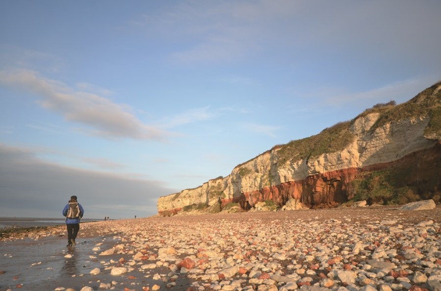
It was winter and an icy wind whipped up the distant waves as I trod over the seaweedcoated rocks. I passed the remains of the Sheraton, a wrecked trawler from 1947, and gazed up at the famously stripy cliffs – made from brown carstone, white chalk and red limestone – while fulmars swooped overhead. It already felt a million miles away from the fairground and donkey rides I’d left behind.
As I made my way inland, passing the beach huts at Old Hunstanton and Holmenext- the-Sea, the path ahead was coated in a layer of snow. It stretched from the sandy path right down to the water’s edge.
More birds greeted me as I edged the observatory at Broad Water – and it had been over an hour since I’d seen another walker. Even passing through Thornham, people were at a minimum, and by the time I turned into the fields near Choseley, making my way to Brancaster Staithe, the sun was beginning to set.
The sky was burnt auburn as I passed the site of the Roman fort of Branodunum and traced the path through the harbour and onto my waiting campsite at Burnham Deepdale. On a long-distance path just finishing a section is rewarding, but knowing that every stage of this trail is as good as this makes you thirsty for more. This was to be the start of my love for multi-day walking.
ROUTE DESCRIPTION
- [1] The Norfolk Coast Path officially begins by the war memorial indicated by a marker post. Continue past the giant painted poppies and follow the waymarked trail along the cliff top to come to the path to the beach. Continue on the waymarked trail behind the beach huts to the RNLI boat shed in Old Hunstanton.
- [2] Cross in front of this to join the path that continues behind the huts. Ignore the old route of the Norfolk Coast Path marked on the OS map and skirt the edge of the golf course before bearing L to reach the top of the sand dunes. Follow the path along here to reach the crossroads with the Peddars Way.
- [3] Continue on the path, first on a wooden boardwalk, before veering R and heading inland. Follow the path through the trees, past Broad Water and follow signs to the road. R into Thornham.
- [4] In the village, L onto the main road and follow it until you R on a road signposted to Choseley. Follow the road uphill, heading inland. Before reaching Choseley, there’s a small patch of trees where the route is waymarked L; follow it, emerging into a field. Follow the track through the fields until you sweep L downhill to a crossroads of the A149 and B1153 in Brancaster village.
- [5] Cross the main road heading N then R off the road to skirt the edge of Brancaster heading E. Pass the Roman fort of Branodunum. Continue through Staithe Yacht Club and about a kilometre later, at a crossroads, R into Burnham Deepdale.

Phoebe Smith takes a surprising Norfolk walk
Nothing beats the feeling you get reaching the summit of a mountain – except perhaps for the sheer elation felt when completing your first long-distance path. For me, the Peddars Way and Norfolk Coast Path was my first foray into the world of National Trails. At 155 kilometres – the shortest of the 15 routes that make up the network – it seemed an easily achievable choice, plus it looked flat… but don’t be deceived as I was. For what it lacks in distance and ascent it makes up for in variety – from Breckland forest and muntjac deer to big skies, wild marshland and sheer clifftops. Offering an enticing mix of inland and coastal landscape, by the time I reached Hunstanton, where this route starts, I was practically giddy with anticipation at the thought of finally smelling the briny sea air.
Starting in the Victorian seaside resort of Hunstanton may fool you into thinking that Norfolk’s northern coast is all deckchairs and jellied eels, but it soon changes. As I’d already walked along the promenade on my way in from Holme-next-the-Sea, after I started at the war memorial on the Norfolk Coast Path leg of the complete trail, with the tide out, I decided to deviate from the path and walk on the beach.
It was winter and an icy wind whipped up the distant waves as I trod over the seaweedcoated rocks. I passed the remains of the Sheraton, a wrecked trawler from 1947, and gazed up at the famously stripy cliffs – made from brown carstone, white chalk and red limestone – while fulmars swooped overhead. It already felt a million miles away from the fairground and donkey rides I’d left behind.
As I made my way inland, passing the beach huts at Old Hunstanton and Holmenext- the-Sea, the path ahead was coated in a layer of snow. It stretched from the sandy path right down to the water’s edge.
More birds greeted me as I edged the observatory at Broad Water – and it had been over an hour since I’d seen another walker. Even passing through Thornham, people were at a minimum, and by the time I turned into the fields near Choseley, making my way to Brancaster Staithe, the sun was beginning to set.
The sky was burnt auburn as I passed the site of the Roman fort of Branodunum and traced the path through the harbour and onto my waiting campsite at Burnham Deepdale. On a long-distance path just finishing a section is rewarding, but knowing that every stage of this trail is as good as this makes you thirsty for more. This was to be the start of my love for multi-day walking.
ROUTE DESCRIPTION
- [1] The Norfolk Coast Path officially begins by the war memorial indicated by a marker post. Continue past the giant painted poppies and follow the waymarked trail along the cliff top to come to the path to the beach. Continue on the waymarked trail behind the beach huts to the RNLI boat shed in Old Hunstanton.
- [2] Cross in front of this to join the path that continues behind the huts. Ignore the old route of the Norfolk Coast Path marked on the OS map and skirt the edge of the golf course before bearing L to reach the top of the sand dunes. Follow the path along here to reach the crossroads with the Peddars Way.
- [3] Continue on the path, first on a wooden boardwalk, before veering R and heading inland. Follow the path through the trees, past Broad Water and follow signs to the road. R into Thornham.
- [4] In the village, L onto the main road and follow it until you R on a road signposted to Choseley. Follow the road uphill, heading inland. Before reaching Choseley, there’s a small patch of trees where the route is waymarked L; follow it, emerging into a field. Follow the track through the fields until you sweep L downhill to a crossroads of the A149 and B1153 in Brancaster village.
- [5] Cross the main road heading N then R off the road to skirt the edge of Brancaster heading E. Pass the Roman fort of Branodunum. Continue through Staithe Yacht Club and about a kilometre later, at a crossroads, R into Burnham Deepdale.


