
Serious weather doesn’t have to mean a day inside. Roger Butler follows plan B: a low-level Latterbarrow walk with high-level views
The threat of black ice, particularly in somewhere like the Lake District, can mean a hasty change of plan. Twisting roads and unexpected frozen patches don’t go together very well and, combined with dollops of thick fog, the local driving conditions forced us to abandon plans for the Fairfield Horseshoe and stay closer to the cottage. In the knowledge that safe was definitely better than sorry, we quickly assessed options and agreed that every now and again there’s nothing wrong with exploring a new, albeit lower, part of the National Park. This Latterbarrow walk, at 14km/8.5 miles in length, with 480m/1575ft of ascent, and taking around 6.5 hours to complete, is a good option in poorer weather.
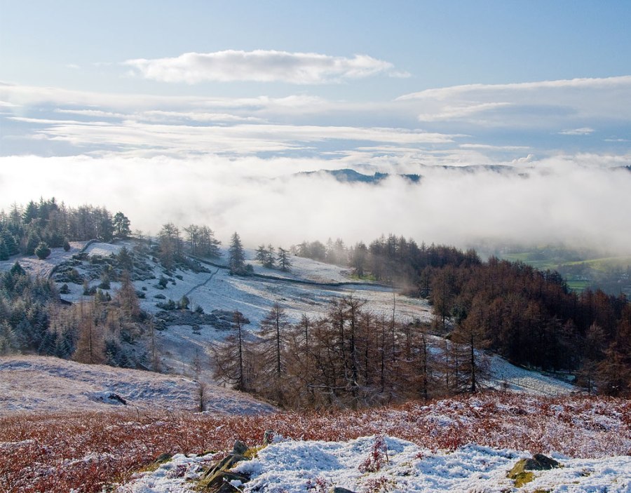
The air was cold and dank by Windermere, but there were hints of brightness as we climbed the western side of Latterbarrow. Fresh snow carpeted slopes which only yesterday glowed an angry russet when the setting sun poured across the Hawkshead valley. Latterbarrow is a famous viewpoint, but by the tall summit cairn all we could do was keep our fingers crossed.
Looking for something to keep off the wind? Check out our gear guide to windshells.
We waited, and as we built a plump little snowman, Coniston Old Man made a first glistening appearance above banks of billowing cloud. When Windermere briefly came and went it seemed like the murk was still likely to win, but gut instincts continued to say the sun would shine. We waited and shivered, patience at stretching point, until, quite suddenly, there was that magical moment when we knew blue sky was going to prevail.
A patch of violet haze now hovered somewhere over Grizedale, but the wind insisted on filling it with fresh cotton wool. Then, just a few seconds later, a shimmering Morecambe Bay emerged from the mist. It all happened so quickly: one by one the Coniston Fells were revealed, followed by the Langdale Pikes and the freshly plastered peaks around Fairfield and Red Screes. Wansfell, High Street and the distant Howgills majestically swept into view. Cloud boiled below Wetherlam, but soon the 360º panorama was fully complete. Cameras whirred into action and Claire thought we should have risked the roads: “Look at Fairfield now!” It didn’t last. Forty minutes later dark clouds had drawn a curtain from the north and the Fairfield Horseshoe was the first to vanish. It wasn’t long before all the summits had disappeared and our earlier decision was fully vindicated. We descended south into a mix of forest, marsh and meadow and followed a network of paths uncovered during recent tree-felling.
The forestry led into an interesting and undulating landscape dotted with pools, tarns and walled enclosures. By now snow had arrived and thick flakes were falling silently onto our track as we strode down to Far Sawrey. A couple of hours later, back by the lake’s reedy shore, we watched a pair of goosanders and skimmed stones between the lichen-draped trees. The water lapped under their roots and we pretended this was Windermere’s long lost mangrove swamp.
ROUTE DESCRIPTION
- From the car park follow lakeside path N to High Wray Bay. By second boathouse take bridleway NW from lake alongside wood. At lane turn L, after 200m take path on R.
- Go over two stiles to reach grassy track leading to lane at Hole House. Take lane SSW, uphill, to join another lane and turn R. Continue for 700m and turn L on signed path to Latterbarrow, with choice of routes to the top.
- Descend S from summit to reach stile by edge of forestry. Turn L and follow path rising E then S, crossing cleared valley to reach track and turn L.
- After 200m take track leading R. Continue, past cleared forestry, to junction of paths/ tracks. Turn R uphill, now heading SW, past Highs Moss Tarn.
- Cross stile at end of forestry and continue S on track descending past tarns, and through gate, to Moss Eccles Tarn. Continue S, after 700m fork SE to reach road at Far Sawrey.
- Turn L for 250m, take bridleway veering N, turning NE after 300m. After 500m take L fork then, by wall, follow W side of trees and take path uphill into forestry at Low Pate Crag. Continue N for 2km to join well made track dropping down to lakeshore by Belle Grange.
- Turn N along lane to return to start.


