In Gwydyr Forest Andrew Galloway finds water wherever he goes.
Whether in the stillness of Llyn Crafnant & Llyn Geirionydd, crashing through the Llugwy river gorge, or tumbling over the leafy crags of Coed Felin Blwm, water forms an integral part of the Gwydyr Forest landscape. The ample supply of this natural resource made these wooded foothills of the Carneddau attractive to the 19th century mining industry. The area is dotted with reservoirs, criss-crossed with meandering leats, built to feed the water wheels that powered the machinery of the metal mines, from which lead and zinc were extracted. Llyn Geirionydd is popular with water sports enthusiasts. The village of Llanrhychwyn is less than a mile away. Anyone who knows anything about the Welsh language will know that “llan” often refers to the location of a church. Rhychwyn is believed to have been one of twelve sons of Helig ap Glannog, a 6th century prince who, according to legend, lived on the isle of Llys Helig, until it was submerged by the waters of the Menai Straight in a violent storm. Established by Rhychwyn in honour of his father, this church is believed to be the oldest extant site of Christian worship in Wales.
Gwydyr Forest waterfalls: route description
Start/Finish: Gwydyr Car Park located on the B5106 close to the Llanrwst sports fields | Distance: 20 km (12 miles) | Ascent: 626m (2,050 feet) | Time: 5 hours | Maps: Ordnance Survey 1:25,000 Yr Wyddfa/Snowdon Dyffryn Conwy Valley OL17
1. SH797614: Either before or after the walk it is worth making the short detour to Pont Fawr, or the Great Bridge, a three arched stone bridge spanning the River Conwy. This well known symbol of the town of Llanrwst was reputedly designed by the Renaissance architect Inigo Jones in 1636.

Pont Fawr and Tu Hwnt I’r Bont tearoom. Credit: Andrew Galloway
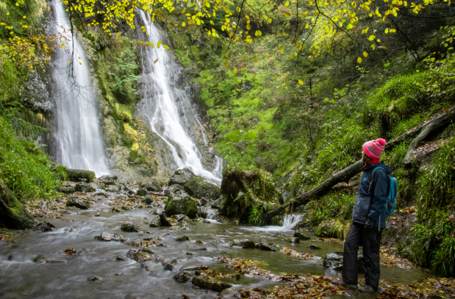
From the car park walk SW along the B5106 for 500m to crossroads. Keep to the right along B5016 in the direction of Trefriw for 300m. On the left you will see the gated entrance to Coed Felin Blwm. Follow the path into the woods to find The Grey Mare’s Tail. Climb the steep path to its right. Above the falls a gate leads onto a minor road.
The Grey Mares Tail, Coed Felin Blwm. Credit: Andrew Galloway
2. SH789610: Turn to the left and follow the road for 150m to where the stream passes beneath. At the junction turn right. After 100m, leave the road and pass through a gate onto a well-defined track. Take the track to the S for 800m to where paths diverge at disused mine workings. Continue on the track into the forest heading SSE for 1.5km to where tracks intersect above Llyn y Parc. Keep on the forest track heading S for 400m to reach the dam at the southern end of the lake.

Abandoned mine workings Gwydyr Forest. Credit: Andrew Galloway
3. SH793583: Cross the dam and keep to the forest track now heading SW through the forest for 300m. Where the track divides turn left. After 200m the track divides again. Turn right and follow it as it meanders around enclosures to the S of Tan-y-Castell. After 600m a crossroads is reached close by Pen-yr-allt-ganol. Keep ahead, taking the track to the W for 400m. Where tracks divide turn to the left, now heading S for 650m. Just south of a transmitter tower the track forks, the branch to the right zig-zagging downwards through the forest towards Betws-y-coed. After 500m turn right, continuing downhill for a further 400m to reach a minor road above the Miners’ Bridge.

Swallow Falls, Afon Llugwy. Credit: Andrew Galloway
4. SH781569: Take the minor road to the W for 200m then branch away onto the footpath that keeps close to the banks of the River Llugwy. Follow this path for 850m to where it intersects with the road. After 200m take the track to the right. Now follow the Snowdonia Slate Trail above the gorge of the River Llugwy for 950m. Just to the W of Swallow Falls a forest track branches right, away from the river. Follow this track for 600m to where it meets a minor road above Ty-hyll.
5. SH757577: Turn right and follow the minor road uphill for 200m to a forest track heading west. Follow this track along the edge of the forest for 800m to an intersection of paths above Glyn Farm. Continue along the forest track, now heading N, for 1.5km passing Llyn Goddionduon on the right. Reach Llyn Bychan.

Llyn Geirionydd. Credit: Andrew Galloway
6. SH751592: Follow the track on the E of the lake for 300m. Where tracks diverge take the track to the left, heading over open moorland for 800m. As the track re-enters the forest it splits. Keep to the right, following the track downhill through the forest for 1km to Llyn Geirionydd. Continue along its W shore for 1km to where the path meets the minor road at the lake’s N limit.
7. SH765614: Now follow the minor road for 1.3km to where it turns sharply to the left. A finger post above a gate in the hedge bears the word Eglwys (church). Pass through the gate and cross the field to arrive at Saint Rhychwyn church.
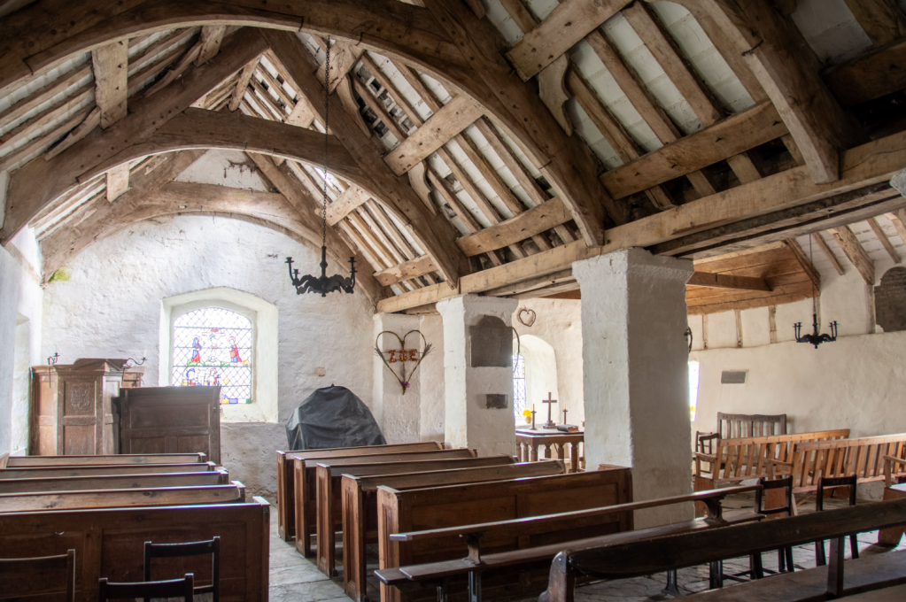
Saint Rhychwyn’s church, Llanrhychwyn. Credit: Andrew Galloway
8. SH774616: Beyond the church a path leads down to a cluster of buildings. From here take the track E for 500m to a minor road. Follow the road SE for a 1km to reach the gate above The Grey Mare’s Tail. Descend the path to the waterfall, through the wood onto the B5106 road. Take the road for the final 800m to the Gwydyr car park.
Further information
Public Transport: The number 19 bus service runs at regular intervals from Llandudno, to Llanrwst and Betws-y-coed.